The saltiest lake on earth. The saltiest lake. The saltiest lake in the world: is there life in it?
May 23, 2016 Salt lakes are more correctly called mineral lakes; lakes with a mineralization of more than 1 ppm (thousandth part) are considered as such. Most often, salt lakes are drainless reservoirs located in an arid zone.
We will briefly talk here about the seven largest salt lakes on our planet:
In terms of the size of its water area, it is really more of a sea, and quite large at that (371,000 km²), although the Caspian Sea is an endorheic salt lake, the largest on the planet. Caspian coast with its sandy beaches, mineral springs, therapeutic mud has good conditions for relaxation and treatment. However, due to difficulties in interstate relations Caspian states - Russia, Iran, Turkmenistan, Kazakhstan - tourism infrastructure in the Caspian Sea is poorly developed.

A former salt lake on the border of Uzbekistan and Kazakhstan. It is called “former” because from the beginning of the 1960s the lake began to become catastrophically shallow due to the increased intake of fresh water for the development of cotton growing from the large rivers flowing into it - the Syr Darya and Amu Darya. Currently, the Aral Sea has split into two isolated lakes - the Northern Aral and the Southern Aral.
Dead Sea

The coast of this salt lake on the border of Israel, the Palestinian Authority and Jordan is the lowest landmass on Earth. The water in the Dead Sea is mineralized to a very high degree; this property has been used for medicinal purposes since ancient times and today attracts a large number of tourists.
Great Salt Lake

Great Salt Lake is the largest salt lake (5 thousand km²) in the Western Hemisphere, located in the southwestern United States, in a desert area. Common table salt and Glauber's salt, a valuable chemical reagent and medicinal drug, are actively mined here.
Elton

The largest salt lake in Europe and one of the most mineralized in the world. Located in Russia, in Volgograd region, near the border with Kazakhstan. Industrial extraction of salt from Lake Elton continued until the end of the 19th century, then ceased. Now there is a balneological and mud resort.
Baskunchak

The main “salt mill” of Russia, about 80% of the production of table salt in the country is concentrated here. The lake is located in the Caspian lowland, in Astrakhan region. Deposits of medicinal clays on the coast of Baskunchak made it possible to organize a mud resort here. Tourists are also attracted by the opportunity to visit the picturesque and only Mount Bogdo in the Caspian region, which, together with Lake Baskunchak, has been declared a protected area.

This is a collection of objects located in the Gulf of Mexico, the Arctic and some other places in the world's oceans. Due to the difference in salinity and, as a result, density, the flows of ocean waters in some cases do not mix, but form clear boundaries and form the so-called “shores” of an underwater salt reservoir.
When we all hear the word “lake,” we imagine some quiet body of water surrounded by a visible shoreline. There will be no such lakes in this article. Have you ever heard of lakes that are subject to storm surges and are larger than some seas?
I present to your attention a selection of “the largest lakes in the world,” which includes the 10 largest lakes. Read, rate, leave comments and feedback in discussions.
Sasha Mitrakhovich 22.03.2016 15:06

The most big lake in the world- Caspian Sea.
The Caspian Sea tops the ranking - despite the fact that it is called a sea, in fact it is the largest endorheic lake on the planet. It is located at the junction of Europe and Asia, and is called a sea only because of its size. The Caspian Sea is an endorheic lake, and the water in it is salty, from 0.05 ‰ near the mouth of the Volga to 11-13 ‰ in the southeast.
The Caspian Sea is shaped like the Latin letter S, its length from north to south is approximately 1200 kilometers, from west to east - from 195 to 435 kilometers, on average 310-320 kilometers.
The Caspian Sea is conventionally divided according to physical and geographical conditions into 3 parts - the Northern Caspian, the Middle Caspian and the Southern Caspian. The conditional border between the Northern and Middle Caspian Seas runs along the line Chechen (island) - Tyub-Karagansky Cape, between the Middle and Southern Caspian Seas - along the line Zhilaya (island) - Gan-Gulu (cape). The area of the Northern, Middle and Southern Caspian Sea is respectively 25, 36, 39 percent of the total area of the Caspian Sea.
The length of the coastline of the Caspian Sea is estimated at approximately 6,500 - 6,700 kilometers, with islands - up to 7,000 kilometers. The shores of the Caspian Sea in most of its territory are low-lying and smooth. In the northern part, the coastline is indented by water channels and islands of the Volga and Ural deltas, the banks are low and swampy, and the water surface in many places is covered with thickets.
On east coast Limestone coasts predominate, adjacent to semi-deserts and deserts. The most winding shores are on the western coast in the area of the Absheron Peninsula and on the eastern coast in the area of the Kazakh Gulf and Kara-Bogaz-Gol.
The territory adjacent to the Caspian Sea is called the Caspian region.

Area and volume of water Caspian Sea varies significantly depending on fluctuations in water level. At a water level of 26.75 m, the area is approximately 371,000 km square kilometers, the volume of water is 78,648 cubic kilometers, which is approximately 44 percent of the world's lake water reserves. The maximum depth of the Caspian Sea is in the South Caspian depression, 1025 meters from its surface level. In terms of maximum depth, the Caspian Sea is second only to Baikal (1620 m) and Tanganyika (1435 m). The average depth of the Caspian Sea is 208 meters. At the same time, the northern part of the Caspian Sea is shallow, its maximum depth does not exceed 25 meters, and average depth- 4 meters.
Sasha Mitrakhovich 22.03.2016 15:19

Confidently secured second place among lake superior- the largest, deepest and coldest of the Great Lakes and, concurrently, the largest freshwater lake in the world.
In the north, Lake Superior is limited by the territory of the Canadian province of Ontario, in the west - American state Minnesota, in the south by the states of Wisconsin and Michigan.
The basins of Lake Superior and the northern part of Lake Huron were developed in the crystalline rocks of the southern part of the Canadian Shield, the basins of the remaining lakes were developed in the limestone, dolomite and sandstone of the Paleozoic North American Platform. Basin Lake Superior formed as a result of tectonic movements, pre-glacial river and glacial erosion.

The origin of the water mass of Lake Superior is associated with the melting of the ice sheet, during the retreat of which a number of large lakes were formed in this area, which repeatedly changed their outlines.
In the northern part of the Great Lakes, the coastline is dissected, the islands and shores (up to 400 m high) are rocky, steep, very picturesque, especially the shores of Lake Superior and the northern part of Lake Huron.
Fluctuations in the level of Lake Superior are artificially regulated for the purposes of navigation, energy, etc. The amplitude of seasonal fluctuations is 30-60 cm, the most high level observed in summer, the lowest in winter. Short-term fluctuations in level caused by strong surge winds and seiches reach 3-4 m, tidal height is 3-4 cm
Sasha Mitrakhovich 22.03.2016 15:26

Rounding out the top three is Lake Victoria, a lake in East Africa, in Tanzania, Kenya and Uganda. Located in the tectonic trough of the East African platform, at an altitude of 1134 m. It is the 2nd largest fresh lake world after Lake Superior and the largest lake in Africa

The lake was discovered and named in honor of Queen Victoria by British traveler John Henning Speke in 1858.
Square Lake Victoria 68 thousand square kilometers, length 320 km, maximum width 275 km. It is part of the Victoria Reservoir. Many islands. The high-water Kagera River flows in and the Victoria Nile River flows out. The lake is navigable, local residents They are engaged in fishing on it.
The northern coast of the lake crosses the equator. The lake, with a maximum depth of 80 m, is a fairly deep lake.
Unlike its deep-sea neighbors Tanganyika and Nyasa, which lie within the African gorge system, Lake Victoria fills the shallow depression between the eastern and western sides of the Great Gorge valley. The lake gets great amount water from rains, more than from all its tributaries.
30 million people live in the vicinity of the lake. In the southern and western shores The lake is home to the Haya people, who knew how to grow coffee long before the arrival of Europeans. Main ports: Entebbe (Uganda), Mwanza, Bukoba (Tanzania), Kisumu (Kenya), near north coast Kampala, capital of Uganda.
Sasha Mitrakhovich 22.03.2016 15:30

Lake Huron is the fourth largest among. This lake is in the USA and Canada, one of the North American Great Lakes. Located east of Lake Michigan, connected to it by the Strait of Mackinac. From a hydrographic point of view, Michigan and Huron form a single system (they are connected by the Strait of Mackinac), but geographically they are considered to be separate lakes.

The area of Huron is about 59.6 thousand square kilometers (the second largest among the Great Lakes). The surface height above sea level is about 176 m (same as Michigan), the depth is up to 229 m.
The states of Michigan and the Canadian province of Ontario have access to the lake. The main ports on Huron are Saginaw, Bay City, Alpina (USA) and Sarnia (Canada).
The name of the lake, introduced by the French, comes from the name of the Huron Indian tribe. Manitoulin is located on Huron - the most big Island world, located in a fresh lake.
Sasha Mitrakhovich 22.03.2016 15:37

In the middle of the list, in 5th place among is lake michigan- one of the North American Great Lakes.
The only Great Lakes located entirely within the United States. Located south of Lake Superior, connected to Lake Huron by the Strait of Mackinac, with the Mississippi River system - the Chicago - Lockport Canal.
From a hydrographic point of view, Michigan and Huron form a single system, but geographically they are considered to be separate lakes.

Square Michigan- about 57,750 km2 (the third largest among the Great Lakes), length about 500 km, width about 190 km. The surface height above sea level is 177 m (same as Huron), the depth is up to 281 m. It is covered with ice for about four months a year. Islands - Beaver, North Manitou, South Manitou.
The states of Michigan, Indiana, Illinois and Wisconsin have access to the lake. Big cities on Lake Michigan include Chicago, Evanston and Highland Park (IL), Milwaukee and Green Bay (WI), and Gary and Hammond (IN).
The name of the lake comes from the word mishigami, meaning “big water” in the Ojibwa Indian language. The first European to discover the lake was the Frenchman Jean Nicolet in 1634.
Sasha Mitrakhovich 22.03.2016 15:42

Sixth among is Aral Sea.
The Aral Sea is an endorheic salt lake in Central Asia, on the border of Kazakhstan and Uzbekistan. Since the 1960s of the 20th century, sea level (and the volume of water in it) has been rapidly declining due to the withdrawal of water from the main feeding rivers Amu Darya and Syr Darya for irrigation purposes. Before the start of shallowing, the Aral Sea was the fourth largest lake in the world.
Collector-drainage waters flowing from the fields into the bed of the Syr Darya and Amu Darya have caused deposits of pesticides and various other agricultural pesticides, appearing in places on 54 thousand square kilometers of the former seabed covered with salt. Dust storms carry salt, dust and toxic chemicals up to 500 km. Sodium bicarbonate, sodium chloride and sodium sulfate are airborne and kill or retard the development of natural vegetation and crops. Local population suffers from a high prevalence of respiratory diseases, anemia, cancer of the larynx and esophagus, and digestive disorders. Liver and kidney diseases and eye diseases have become more frequent.

In 2001, as a result of a drop in water level, Vozrozhdenie Island connected with the mainland. On this island, the Soviet Union tested bacteriological weapons: the causative agents of anthrax, tularemia, brucellosis, plague, typhoid, smallpox, as well as botulinum toxin were tested here on horses, monkeys, sheep, donkeys and other laboratory animals. This is the reason for fears that deadly microorganisms have remained viable, and infected rodents may spread them to other regions.
According to scientists' calculations, it is no longer possible to save the Aral Sea. Even if we completely abandon the intake of water from the Amu Darya and Syr Darya, the previous water level in it will be restored no earlier than in 200 years.
The Aral Sea once occupied 68 thousand square kilometers and was the fourth largest in area in the world. Now its area is about 10% of that recorded in the 60s of the last century. Photos from 1989 and 2003:
From the 1950s to the present, projects have been repeatedly proposed for the construction of a canal to transfer water from the Ob basin to the Aral Sea basin, which would significantly develop the economy of the Aral Sea region (in particular, Agriculture) and partially revive the Aral Sea. Such construction will require very large material costs (on the part of several states - Russia, Kazakhstan, Uzbekistan), so there is no talk yet about the practical implementation of these projects.
Some scientists predict Aral Sea complete disappearance by 2020...
Sasha Mitrakhovich 22.03.2016 15:47

Lake Tanganyika — large lake in Central Africa. This is one of and equally ancient in origin. In terms of volume and depth, Tanganyika ranks second after Lake Baikal. The shores of the lake belong to four countries - Democratic Republic Congo, Tanzania, Zambia and Burundi.
The length of the lake is about 650 km, width is 40-80 km. Area 34 thousand sq. km. It lies at an altitude of 773 meters above sea level in the tectonic basin of the East African Rift Zone. Coastal landscapes, as a rule, consist of huge rocks and only on the eastern side the shores are gentle. On the west coast, the steep side walls of the East African Rift Zone that form the coastline reach 2000 m in height. Coastline dotted with bays and bays. The largest of them is Burton Bay. The lake is fed by several tributaries. The only river that flows out is the Lukuga, which begins in the middle part west coast and flows west, connecting with the Zaire River, which flows into the Atlantic.

The lake is home to hippopotamuses, crocodiles, and many waterfowl. Fishing and shipping are well developed.
The antiquity of the lake and the long period of isolation resulted in the development of a large number of endemic organisms, including those from the family Cichlidae (cichlids). Of the more than 200 species of fish found in the lake, about 170 are endemic.
Tanganyika is inhabited to approximately a depth of 200 m; below this level there is a high concentration of hydrogen sulfide and there is no life until the very bottom. This layer of the lake is a huge “burial ground” consisting of organic silt and sedimentary mineral compounds.
The water temperature of Tanganyika varies strictly among layers. So, in top layer temperature ranges from 24 to 30 degrees, with a decrease of great depths. Due to different densities of water and the absence of bottom current, the layers do not mix, and the temperature on the lower horizons reaches only 6-8 degrees.
The depth of the temperature jump layer is about 100 m. The water of Tanganika is very transparent (up to 30 m). Many salts are dissolved in it in small concentrations, so its composition resembles highly diluted sea salt. Water hardness (mainly caused by magnesium salts) ranges from 8 to 15 degrees. Water has an alkaline reaction, pH 8.0 - 9.5.
The saltiest lake in the world - extraordinary and amazing a natural phenomenon. Similar reservoirs are found on almost all continents. Antarctica is no exception in this case. In America and Russia there are entire zones where there are a huge number of similar reservoirs. But what is the saltiest lake in the world?
Dead Sea
The list of largest lakes by area is topped by the Dead Sea. Many may disagree with this. After all, this is not a lake, but a sea. However, it is not. is drainless, since it has no outlet to any of the oceans. This lake is located on the border between Jordan and Israel. This reservoir is not very large in size. Its length is 76 kilometers, its width is only 18, and its maximum depth is 370 meters. total area Dead Sea- 810 m2. Gradually the lake decreases in size.
Only one of the major rivers flows into this body of water - the Jordan. Small streams also feed the Dead Sea. However, the water in the lake quickly evaporates, since the air temperature here often drops below 40 o C. Salts, on the contrary, remain and accumulate. Besides fresh rivers, Dead Sea nourish and mineral springs located on it south coast. As a result, the salt concentration only increases and amounts to approximately 28%. And in some places this figure reaches 33%. For comparison, you can take the waters of the World Ocean. Here the salt concentration is a maximum of 4%. The Dead Sea itself flows near its northern shores. Here the salt concentration is only 24%. It is in this part that it flows into it. As you can see, this information about this reservoir changes every year. After all, the water level decreases and the salt concentration increases.

Lakes also have legends
On south coast Nature has created amazing pillars of the Dead Sea. This happened due to the fact that there is much more salt in this part of the reservoir, and the water evaporates quite quickly. One of these pillars resembles a female figure dressed in a cloak. She even has her own name - “Lot’s wife.” It is connected with one of the biblical legends, which tells how God decided to punish Gomorrah and Sodom. He warned one of the righteous - Lot - about his intention and ordered him to leave the city before its fall, without stopping along the way and without turning around. However, Lot's wife violated the ban and was eventually punished by turning into a pillar of salt.
The saltiest lake in the world: is there life in it?
The name of the Dead Sea speaks for itself: there is no life in it. There are no fish and no algae growing here. The banks of the reservoir are also lifeless. Even the surface of the Dead Sea bears no resemblance to the surface of water. It looks more like an oily liquid with a metallic tint with white flakes of salt in smaller places.
However, scientists say that this body of water is not completely dead. It is inhabited by salt-loving bacteria, and sometimes even fungi are found.

Features of the Dead Sea
The world's saltiest lake has many features. First of all, its waters are rich in various minerals, such as iodine, sodium, potassium and boron. ABOUT beneficial properties The salt solution of this reservoir was known to ancient healers. Dead Sea water helps heal all kinds of skin diseases.
However, swimming in this lake is almost impossible. After all, salt water can corrode the skin. If such a solution gets into any wound, not entirely pleasant sensations will arise. This is why swimming in the Dead Sea is not so pleasant. This is rather the lot of exotic lovers or those who are forced to take such water procedures as prescribed by doctors.
By the way, diving in the Dead Sea is difficult, since its waters are a thick salt solution. A person can only swing on the surface of the lake like a float. It is simply impossible to drown in the Dead Sea. In addition, the coast of the reservoir is considered a rather low place on land. It is located only 0.4 kilometers below the level of the World Ocean.
Lake Don Juan
This is another of the saltiest lakes in the world. However, few people know about its existence. Lake Don Juan is located on a glacial continent - in Antarctica. To be more precise, on the lands of Victoria in the Wright Valley. By the way, the hydronym has nothing to do with the famous ladies' man - the lake is named after those people who first discovered it. These were helicopter pilots John Hickey and Don Ro. They discovered the lake in 1961. It is very small in size. Around 1998, it was just under 100 meters deep, 1 kilometer long and 400 meters wide.

On this moment The reservoir has significantly decreased in size. Now its depth is only 10 centimeters, length - 300 meters, and width - 100 meters. The water evaporates from it quite quickly. At the same time, Lake Don Juan does not dry out completely. It is supported by underwater springs. After all, this reservoir is one of those places where groundwater comes to the surface.
Why is the lake salty?
Scientists suggest that the lake became salty due to the large amount of salts contained in sedimentary rocks. It is through them that melt water from the springs passes. These sources are the main recharge of Lake Don Juan. At the same time, the air in the valley is very dry. Under such conditions, water evaporates much faster. At the moment, Lake Don Juan is ahead of the Dead Sea in terms of salt concentration. Now this figure is 40%. Due to such a fairly high concentration, the reservoir does not freeze even at a temperature of -40 o C.
As you can see, Lake Don Juan is the saltiest lake in the world. But in size it is significantly inferior Dead Sea. Scientists also became interested in this body of water because the conditions in this so-called water area (intense cold, aridity, hypersalinity and high ultraviolet radiation) are very reminiscent of those on the surface of Mars.
Lake Elton
The largest salt lakes in the world are a true miracle of nature. In Volgogradskaya there is a reservoir Elton. This is the largest lake with mineral waters throughout Europe. This body of water is almost circular in shape. The lake is located in a depression between salt domes. At the same time, the reservoir has no flow. The most amazing thing is the color of the water. It has a reddish tint.
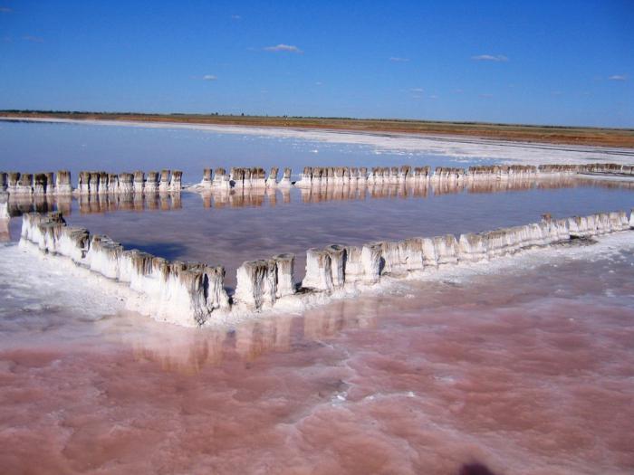
This color is given to Lake Elton by the bacteria living in it, which are representatives of the species Dunaliella salina. Not long ago salt was mined here.
The Dead Sea is famous for its unusually high salt content, although in fact this body of water ranks only as the fourth saltiest sea and lake in the world.
Seas and oceans are traditionally considered to be the saltiest bodies of water. And this is mostly true. Water occupies more than two-thirds of our planet's surface, and 96% of it is found in the oceans. Ocean waters contain thousands of billions of tons of dissolved salt.
The salinity of water varies at different points in the oceans. Around the poles, the constant presence of snow and ice reduces salt levels, while closer to the equator evaporates from the surface of the seas more water, which means higher salt content in the water.
But there are bodies of water on our planet where there is much more salt than in the seas and oceans.
Dead Sea
The most famous such body of water is the Dead Sea, located on the border of Jordan and Israel. The water here is 10 times saltier than the average sea water. However, the Dead Sea is far from the saltiest sea. It ranks only fifth among the saltiest bodies of water on Earth.
In addition, the Dead Sea is not a sea at all. Although the term "sea" is used quite loosely, it essentially refers to a large body of salt water that is partially surrounded by land. The Dead Sea is completely surrounded by land and has no access to the ocean or open sea. In fact, it is a lake, but it is large and salty, which causes confusion.
The shore rocks of the lake sparkle with crystallized table salt in places where the sun causes the water to quickly evaporate. In addition, the Dead Sea is the deepest hypersaline body of water in the world. Its depth reaches 330 meters.
IN last years this body of water rapidly decreased in size, to the point that rumors arose about its complete disappearance. However, Israeli geologists now claim that it will stabilize at current levels in the near future.
Lake Don Juan
Despite its celebrity status, the Dead Sea cannot take away the laurels of the saltiest body of water from a tiny lake called Don Juan. This baby does not exceed 300 meters in length and 100 meters in width, and its depth is 10 centimeters. However, the percentage of salt content in the lake is 44%, which is 10% more than in the Dead Sea and 40% more than in the ocean.
The lake is located in Antarctica, in the McMurdo Dry Valley, famous for being the driest place on the planet - there is no precipitation, and strong winds prevent glaciers from forming on the interior of the mountains surrounding the valley.
Source of salt
Scientists do not know the exact reason for such a high salt content in the lake water. Perhaps this is due to the fact that it is completely cut off from other bodies of water and is not diluted by fresh water coming from precipitation and thanks to the melting of glaciers. All the salt contained in the waters of Don Juan cannot leave them. All she can do is freeze or evaporate.
With such a high percentage of salinity, the lake almost never freezes - this requires a temperature below -53 degrees Celsius. All that remains is evaporation. The water evaporates, resulting in an even higher percentage of salinity.
While other salt water bodies of Antarctica receive fresh water of snow and ice, Don Juan always remains undiluted. Scientists are still trying to find the source of salt in the waters of the lake.
Salt on land
It is noteworthy that reservoirs are far from the saltiest places on the planet. Record accumulations of this mineral are found on land.
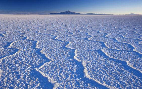
The Uyuni Salar is the largest in the world, its area exceeds ten thousand square kilometers. It is located in Bolivia and is actually the bottom of a dry prehistoric salt lake.
The basin of this lake is unusually flat; geologists noticed a difference in height of only one meter. Today this huge flat valley is covered in sparkling salt crystals.
During the rainy season, tourists flock to Uyuni to see the world's largest mirror surface, and flamingos come here to lay eggs, perching on large salt marshes.
Salt has been mined in the vast expanses of Uyuni for several centuries, but there is still so much of it that it will last for a long time.
Underground springs
Although the largest deposit of salt is in Bolivia, the largest exporters of this mineral are Australia and China. The most productive salt mines are located there.
However, the largest salt mine is located in Canada. Its depth reaches 550 meters, and its area is seven square kilometers. Seven million tons of salt are extracted from the mine every year. This place is near the Great Lakes, and geologists assume that the salt deposits there are very rich and lie at comparatively great depths, covering a huge area. This wealth is left over from a prehistoric sea that dried up about 420 million years ago.
The fact that it is difficult for scientists to name the single saltiest place on Earth tells us that there is still much to be learned from the history and depths of our amazing planet not studied and kept secret. It is quite possible that there is another body of water in the wilds Siberian forests, which will be saltier than Lake Don Juan.
What is the saltiest lake in the world? The most famous is the Dead Sea in the Middle East, in which, due to the high density of water, it is impossible to drown. But the palm does not belong to him. Several lakes in the world have a salt content greater than the Dead Sea. Here is a list of the saltiest lakes in the world:
The saltiest
All the lakes on the list of the saltiest (of course, except for Lake Don Juan) have long been places of salt production. Over time, various hospitals were added to the salt pans, because the microclimate that developed around such lakes has a beneficial effect on the human body, and many diseases can be treated with mud. For example, the salt deposit of Lake Elton began to be regularly developed during the time of Ivan the Terrible, shortly after his conquest of the Astrakhan Khanate. During the reign of Empress Elizabeth Petrovna, two roads were built for the export of salt, and by decree of the government Senate on February 27, 1747, the “Commission for Salt Extraction” was established.
Since the end of the 19th century, Elton has had exclusively resort significance; salt production there has been discontinued. But Lake Baskunchak combines “two in one”. Here not only salt is mined, but also a whole bunch of diseases are treated. Baskunchak's salt is the purest table salt in the world, covering up to 80 percent of the needs of the Russian market.
Lake Baskunchak is also famous for the fact that in the 60s of the last century a track was built on it to set All-Union speed records. As a result, from 1960 to 1963, 29 records were set, including 19 international ones. The maximum speed was 311.4 km/h. Subsequently, due to the ongoing development of the salt deposit and the deterioration of the hydrological situation, the route, where there was a 13-kilometer straight section, was closed.
The Dead Sea is widely known as an international resort; among the five record holders it has the most large area and the most developed infrastructure. Despite this, salt mining continues there today. But sea levels, unlike their Russian counterparts, are regularly falling. However, at great depths, complete shallowing will not occur soon.
Lake Assal in the small African state of Djibouti is located just 5 kilometers from Indian Ocean and 155 meters below its level. It occupies a crater extinct volcano. There is not a single sanatorium on the lake, which lies in a very turbulent (in a social sense) region of Africa. Salt is only mined here and delivered by caravans to neighboring Ethiopia.
Antarctic phenomenon
Lake Don Juan was discovered in 1961, and was named after the helicopter pilots who first discovered it: Don Ro and John Hickey. Obviously, when they gave the name, they decided to play on the name Don Juan, known from literature, and the English “John” was translated into Spanish. At the time of discovery, the water temperature was -30 degrees Celsius, but due to the high salt content, the lake did not freeze. His exact description was obtained only in the 70s of the last century.
The 1977 directory states that the area of the lake is 0.25 km 2, and its average depth is about 30 centimeters. Twenty years later, the area and depth of the reservoir were greatly reduced. Today it is just a very large salt puddle with an area of 3 hectares with an almost perfectly flat bottom. No life, including bacteria, was found in the lake.
It is located in an area of Antarctica called Victoria Land, in the Wright Valley. The average salinity is 402 ppm, with some measurements showing a value of 413. Lake Don Juan is described as the point of release of highly mineralized groundwater to the surface. Thanks to the unique natural conditions- constant strong winds and very dry air - the water evaporates, leaving the carried substances in the reservoir. Due to the high concentration of salt, the lake does not freeze even at temperatures as low as -53 degrees Celsius.
All of these bodies of water have a very high concentration of salt, exceeding the salinity of the World Ocean by more than an order of magnitude. Which of them is more worthy of the title “the saltiest lake in the world”? In absolute value, this is Elton - 500 ppm. But sometimes, with an abundance of meltwater, the lake becomes much fresher, restoring its primacy in dry years. And the Dead Sea, with its continuing shallowing, has good “prospects” to take sole leadership after some time. This lake has the greatest depth and area and, as a result, the largest volume of water and the total amount of minerals.