What happened to the Aral Sea. Aral Sea. Aral Sea-Lake: why the disaster happened
The Aral Sea is a unique lake (sea) in Central Asia. Aral Sea - Aral ... This word, which has come down to us from ancient times, means "island". The sea and suddenly - the island! Isn't it strange? But remember, by the way, that the most precious lands were called "islands" in Rus'.
The Aral Sea - the story of death
The biosphere is a very vulnerable shell of the Earth. If certain ties are broken, then only yesterday the fertile spaces turn into a desert.
The Aral Sea was fed by the Amudarya and Syrdarya rivers. Now all this is in the past. These great rivers, which are among the 34 largest water arteries of the world, do not reach the Aral Sea today.
The death of the Aral Sea - a deliberate work of human hands - is ranked second among world environmental disasters (after the threat of destruction of tropical forests in the Amazon basin). But the consequences of the disappearance of the sea for the vast Central Asian region, and not only for it, can hardly be called anything other than a comparable catastrophe. First of all, because the question is raised about the very existence of people inhabiting this region.
Water inflow to the Aral Sea, until the 1960s balanced by evaporation (about 65 km3/year), has recently ranged from zero to 20 km3/year. The main reason is the increase in water consumption for irrigation, for new, imperfect irrigation systems and reservoirs, which parse and evaporate water on the way to the sea. As a result, the level of the Aral Sea has now decreased compared to the level of 1957. (then the absolute mark was 54m) by more than 14m.
Its area has decreased from 66.5 thousand km2 to approximately 36 thousand km2, the volume of water has decreased from 1000 km3 to almost 320 km3. During this time, water salinity increased from 8-14 g/l to 25-50 g/l. The shoal separating the Aral into Small (Northern) and Large has completely left the water. The Syr Darya has changed its course and now flows not into the Big Aral, as before, but to the north, into the Small Aral. The meridional ridge dividing the Big Aral into eastern and western parts was largely exposed. The drained former bottom of the sea is a desert. Freshwater fish, which used to be caught more than 40 thousand tons per year, has practically disappeared. Due to the high salinity, animals cannot drink water.
The area of the exposed bottom is approximately 3 million hectares. And these lifeless spaces covered with salty sand are expanding. Salt dust storms have become common in the Aral Sea region. Every year, according to the laboratory of space monitoring, about 72 million tons of salt are carried away by the wind outside the Aral Sea region. It carries this caustic dust in a southerly direction up to 500 km, in the east - to the Yangieg region of Uzbekistan, which is near Tashkent, it settles both in the Tien Shan and in the Pamirs, where the Amu Darya and Syr Darya originate. But their water is used by millions of people living in Turkmenistan, Kazakhstan, Tajikistan, Uzbekistan.
Aral Sea - forecasts for the future
Based on the above facts, it is not difficult to imagine what will happen in the future. After all, already today the total amount of salts falling on the soil surface in the Aral Sea region per year has reached an average of 520 kg per hectare. This was one of the reasons for soil degradation here, and in Karakalpakstan, Kyzyl-Orda and Tashauz regions, the most difficult situation has developed for people's health.
 Scientists foresters, having examined the exposed bottom of the Aral Sea, came to the conclusion that it is possible to grow a forest on soils of light composition, to carry out extensive phytomelioration. Experience in fixing sands has been accumulated at the Institute of Deserts of the Academy of Sciences of Turkmenistan. The fundamental possibility of its forest reclamation development by sowing and planting desert species of trees - saxaul, kandym, cherkez has been established. The first landings have been made. Now birds and reptiles settle in these green islands, a new ecosystem has arisen with its own biogeocenosis.
Recommendations on forest reclamation development of the southern part of the drained Aral Seabed have also been published. A project was developed for fixing moving sands and planting seedlings of desert plant species on 326 hectares of the former bottom of the Rybatsky Bay. We also started studying technologies for creating protective plantings. Four years later, up to a thousand plants took root on one hectare of land, and even more in some areas.
The bushes have already reached a height of two meters, developed dense crowns, bloomed and bore fruit. And this means that soon self-seeding of forest species will begin and their number will reach 3 thousand per hectare. Such a process is observed on the drained bottom of the former Muynak and Rybatsky bays.
A new generation of desert plants will completely fix the top layer of soil in a given area, protect it from being blown away by the wind. At the same time, it should be noted that the created crops formed a significant reserve of green mass 4-5 centners per 1 ha in 2-3 years.
At the age of five, this stock has already reached more than 7-10 centners per 1 ha. Without human help, such self-overgrowth would take many years.
The shifting sands do not wait. The desert, if not stopped in time, quickly begins to increase its borders. Creating protective forest plantations is the only way to block the way for sand and dust storms.
Academician A. S. Berg, in his book “The Aral Sea”, written at the beginning of the century, warned that if a reservoir dries up, a layer of salt forms on its bottom. The local winds are strong, the salt will rise up and settle for many hundreds of kilometers from the Aral Sea, including on the Pamir glaciers, where the rivers that feed the sea begin. A disaster will begin. And so it happened.
How to save the Aral Sea
At present, the water level in the Aral can stabilize only if the inflow into the sea increases to 30-35 km3 per year, i.e., to the level of evaporation from the new area of the sea.
 Changing the size of the Aral Sea. Some scientists propose to return to the Aral Sea drainage water that flows from the fields after irrigation or soil washing. Their runoff can reach a total of 10 km3. Collector canals laid to the right and left of the Amu Darya channel will carry from its middle course these water flows withdrawn from reservoirs like Syrkamysh Lake, which was born due to drainage waters.
It is quite easy to imagine that in the very near future it will be difficult to distinguish the Aral water from the water of Sarykamysh in terms of composition. The concentration of salts in Sarykamysh is 2.5 times higher than in the Aral Sea, and the water there is much more poisonous. 5 km3 of waste water to replenish the Aral Sea must travel almost a thousand kilometers along each of the collectors. How much water will reach the sea?
What part of it will be absorbed by natural filtration into the soil? The largest in Central Asia, the Karakum Canal loses to filtration, according to various estimates, from 18 to 47% of the portable volume of water. This is what caused the formation of salt marshes in the desert and flooding of the soil in the Ashgabat region.
If this project is implemented, the Aral Sea will never receive this even untreated water, it will spread across the desert and turn into a "poisonous evaporator".
According to the most conservative estimates of specialists, taking into account the true efficiency of the systems, from 35 to 40 km3 of water is annually lost to filtration and evaporation in the irrigated areas of the Syrdarya and Amudarya basins, which is almost half of the total river flow. According to various estimates, from 5 to 10 km3 of collector-drainage water flows into various depressions and depressions in the middle of the desert, 5 km3 evaporates from the surface of man-made reservoirs.
These reservoirs have already flooded hundreds of thousands of fertile hectares, the lack of which is so sad for other masterminds of the recent massive attack on the desert. Let us take the lower limits of the given estimates. It turns out that at least 45 km3 of water goes anywhere, but not to the Aral Sea.
Watch a video about the Aral Sea:
The Aral Sea will be saved:
ARAL SEA, Aral (Turk. "Aral" - an island; the original name of the area at the mouth of the Amu Darya River, and then the entire lake), a large drainless salty reservoir with characteristic sea and lake features, in the Turan lowland, in Kazakhstan and Uzbekistan. The depression of the Aral Sea was formed as a result of a deflection of the earth's crust in the Upper Pliocene. His age is ca. 140 thousand years. The outlines changed quite significantly as a result of climatic fluctuations, economic activity in its basin, migration of the channels of the main rivers flowing into the sea - the Syr Darya and, especially, the Amu Darya. In the Quaternary, the Amu Darya ended its course alternately either in the Sarykamysh depression, not reaching the Aral Sea, or in the Aral Basin. Accordingly, the Aral Sea either grew shallow or increased in size. Over the past 4–6 thousand years, the amplitude of sea oscillations was more than 20 m. The great medieval regression occurred 400–800 years ago, when the level dropped to 31 m. The remains of saxaul thickets, ancient settlements, and the Kerderi mausoleum were found on the shallow bottom of the Aral Sea. All R. 20th century sea level was relatively stable (minor fluctuations around 53 m). The Aral Sea was the fourth largest lake in the world. At this level, the area was 66.6 thousand km 2, volume 1068 km 3, maximum length 428 km, width 235 km, maximum depth 69 m (with an average depth of 16 m and prevailing depths of 20–25 m), average water salinity 10 -12‰. The water of the Aral Sea was distinguished by high transparency, especially in its central and western parts, far from the mouths of the Amudarya and Syrdarya, the water of which is characterized by increased turbidity. The color of the water in the center of the sea was blue, and off the coast it was greenish. The water was characterized by an alkaline reaction - the pH value was 8.2–8.4. The chemical composition of the water was dominated by sulfate and carbonate with a relatively small amount of chloride ions. The water was characterized by a low content of the main biogenic elements, and according to the trophic level, the reservoir was characterized as mesotrophic. In the Aral Sea to Ser. 20th century lived approx. 20 species of fish (thorn, bream, carp, roach, pike perch, etc.). In the 1950s–60s. 13 more species of fish were introduced. There were more than a thousand islands in the sea, the largest of which are Kokaral, Barsakelmes, Lazareva, Vozrozhdenie. In the south, there was the Akpetka archipelago, which was the sand dunes of the Kyzylkum desert flooded by sea waters. The northern shore is high in some places, low in some places, was cut by bays, the eastern one is low-lying, sandy with a large number of small islands and bays, the southern one is low-lying, occupied by the Amudarya delta, the western one is formed by a cliff (chink) of the Ustyurt plateau up to 250 m high. The climate is continental. The average air temperature in summer is 24–26 °С, in winter from –7 to –13.5 °С. The water temperature of the surface layer in summer is 28–30 °C. In winter, the northeastern and northern parts of the sea usually freeze. The input part of the water balance (64–65 km 3 /year) was mainly (about 90%) the river runoff of the Amudarya and Syrdarya. Precipitation and a small influx of groundwater accounted for slightly more than 10%. The runoff of the Amudarya averaged 44–46 km 3 /year, the flow of the Syrdarya was approx. 10 km 3 / year.
From the beginning 1960s the relative stability of the state of the sea, supported by the inflow of the Amu Darya and Syr Darya waters, was disturbed, mainly due to the rapid increase in water withdrawals, mainly for irrigation needs. From 1960 to 2000, the area of irrigated land in the Aral Sea basin increased from 4.5 to 8 million hectares. The total water intake accordingly increased from 60 to more than 100 km 3 /year. Prior to this, water withdrawal also increased, but the increase in irrigated lands was mainly due to tugai thickets along the rivers, which evaporate a lot of water, and as a result, the river flow changed little. Water intake began to significantly affect the flow of rivers, as soon as from the middle. 20th century irrigation began, often with an excess amount of water, of desert foothill areas remote from rivers, from where only a small part (10–20%) of the withdrawn water returned to the rivers in the form of collector-drainage water from irrigation systems. These waters, saturated with fertilizers and pesticides leached from agricultural fields, made up the bulk of the sharply reduced river inflow into the Aral Sea, which in some years approached zero not only due to water withdrawal, but also due to natural low water determined by climatic conditions. According to most researchers, a 20% decrease in inflow to the Aral Sea is due to climate change, and 80% to anthropogenic factors.
During the period 1961–89, the sea level decreased by more than 14 m, the area of the water area decreased by 2 times, and the volume - by 3 times. In 1988–89, at a mark of 39 m, the Aral Sea was divided into two independent bodies of water - the Big Sea (Great Aral, southern Aral, the Aral Sea itself), fed by the waters of the Amu Darya, and the Small Sea (Small Aral, northern Aral), fed by the waters of the Syr Darya. The area of the Big Aral at its separation was 33.5 thousand km 2, and the Small Aral - approx. 3 thousand km 2. During 1989–2000, the volume of water decreased from 329 to 175 km 3, the area decreased from 36.4 to 24.4 thousand km 2, the level decreased from 39.1 to 34.0 m (see table). The coastline moved away from its previous position in many cases by tens of kilometers (see map). The salinity of the water increased from 29 to 46–59‰. Subsequently, the drying of the sea continued (see table). At a mark of 29 m, the Big Aral was divided into eastern and western parts, and now it has turned into a group of several reservoirs with water salinity in some of them exceeding 200‰.
The shrinkage of the Aral Sea in recent decades has occurred mainly due to the Large Aral, mainly due to the fact that the Small Aral was separated from the Large Aral by a dam. The dam, built in 1994, was washed away in 1999 during a spring storm, but in 2003-05 a more powerful Kokaral earthen dam 13 km long, 6 m high, 100-150 m wide was erected. surplus water to the Big Aral. Due to this, the flow of the Syr Darya accumulates in the Small Aral. By 2008, the water level in it had risen to 42 m, the salinity had decreased to 10–13‰, which made it possible to begin the restoration of the fishery.
Changing parameters of the Aral Sea
| Years/parameters | Water level, m | Volume, km³ | Water area, thousand km² | Mineralization, ‰ | Inflow, km³/year |
|---|---|---|---|---|---|
| 1960 | 53,40 | 1083 | 68,9 | 9,9 | 54–56 |
| 1989 | 39,1 | 329 | 36,4 | 29 | |
| 1990 | 38,24 | 323 | 36,8 | 29 | 12,5 |
| 2000 | 34,0 | 175 | 24,4 | 46–59 | |
| 2003 | 31,0 | 112,8 | 18,24 | 78,0 | 3,2 |
| 2004 | 17,2 | 91,0 | |||
| 2007 | 75,0 | 14,18 | 100,0 | ||
| 2008 | 10,58 | ||||
| 2009 | 8,16 | ||||
| 2010 | 13,84 | ||||
| 2011 | 9,28 | ||||
| 2012 | 8,96 | ||||
| 2013 | 9,16 | ||||
| 2014 | 7,30 | ||||
| 2015 | 8,30 |
In general, the drying up of the Aral Sea is one of the largest environmental disasters of the 2nd half. 20 - early. 21st century, which had an extremely negative impact on the economy of the region. If in ser. 20th century 30-50 thousand tons of fish were caught in the sea, then by the beginning. 1990s it has completely lost its fishery importance. A significant part of the population has lost their jobs. In the beginning. 21st century fish have completely disappeared in most of the Aral Sea. Fishing is now carried out only in the Small Aral. In 2007 the catch was approx. 2 thousand tons and tends to grow. Shipping stopped. The remains of ships can be seen tens of kilometers from the shores of the Big Aral - on the dry bottom of the sea, which has turned into a desert with vast salt marshes and highly saline lands. The dried part of the seabed became the source of large dust storms and wind removal (over 100 thousand tons annually) of salt mixed with various chemicals and poisons, adversely affecting all living things at a distance of up to 500 km. The drying up of the sea affected the climate of the region immediately adjacent to the former water area of the sea (at a distance of up to 100 km from the former coastline), which became more continental: summers became drier and hotter, winters colder and longer.
Economic losses associated with the drying up of the Aral Sea are estimated at several hundred million to several billion US dollars annually.
In the near future, the Great Aral Sea is threatened with complete disappearance, unless the states in its basin take measures to reduce water withdrawal by modernizing the existing irrigation system, switching to less water-consuming irrigation methods and cultivating less moisture-loving crops, transferring part of the production from irrigated lands to non-irrigated ones. It is also important to streamline the use of fertilizers and pesticides. These measures would make it possible to maintain in an acceptable ecological state, if not the entire Big Aral, then water bodies and adjacent ecosystems at the mouth of the Amu Darya.
The fate of the Small Aral is more optimistic. To maintain its ecological state, only 2.5 km 3 / year of pure Syrdarya water is needed. But in the Syr Darya basin, measures to save water and improve its quality are very relevant.
The expected warming of the climate, leading to a decrease in the stock of snow and ice in the mountainous regions of the Aral Sea basin, the main source of water for the Amu Darya and Syr Darya, makes it difficult to solve the problems of the Aral Sea.
Between Kazakhstan and Uzbekistan is the Aral Lake, which has a rich history, being one of the largest salt lakes in the world. But since the middle of the last century, it began to shrink due to the human factor, people needed water to water their livestock and irrigate the land.
Aral Lake: origin
More than 20 million years ago, the lake was a sea and connected to the Caspian Sea. However, scientists found that it once became shallow, and then filled with water again, since human remains dating back to the 1st millennium, as well as the remains of trees that grew in this place, were found at the bottom.
An interesting find after the shallowing was the discovery of several mausoleums and the remains of two settlements. Scientists believed that peoples lived here, and the Kerderi mausoleum, dating back to about the 11th-14th centuries, and the remains of the Aral-Asar settlement, dating back to the 14th century, have been preserved.
The change in the water level was associated with natural cycles, when it either waxed or waned, some rivers stopped flowing, and small islands formed. However, this did not affect the depth of the Aral Lake, continuing to be the largest body of water in the world, although not connected to the World Ocean. The Aral military flotilla was located on the sea, research was carried out, the reservoir was studied.
In 1849 the first expedition led by A. Butakov was carried out. Then an approximate measurement of the depth was made, the islands of Barsakelmes were photographed and part of the Renaissance islands was studied. These islands were formed at the end of the 16th century, when the water level was lowered. In the same expedition, meteorological and astronomical observations were carried out, and samples of minerals were also collected.
Research was carried out even when there were military operations for the annexation of the Central Asian states, and the Aral Flotilla participated in these battles.
At the end of the 19th century, another expedition was created led by A. Nikolsky in the south, and academician Lev Berg in the north. They mainly studied climate, flora and fauna. In 1905, industrial fishing began, when the merchants Lapshin and Krasilnikov created fishing unions.
Catastrophe
In the 30s of the last century, people began to be highly active in agriculture. But the reservoir was still safe, and the water level did not decrease. In the 60s, its decrease began, and already in 1961 the level decreased by 20 cm, and after 2 years by 80 cm. it was unambiguous to answer: Aral Lake - fresh or salty?

In 1989, it completely split into two reservoirs, and they began to call it the Big Aral and the Small Aral. All this affected the number of fish that remained only in Maly.
Aral Sea-Lake: why did the disaster happen?
Upon learning that this reservoir had become so shallow, people wondered why this happened? After all, many people live off rivers and lakes, use their waters not only for agriculture, but also for construction, for drinking, and they do not shrink.
Once the area of the sea was 428 km long and 283 km wide. The inhabitants, located along the coast, lived off the water, fished and earned in this way. For them, grinding turned into a tragedy, and by the beginning of the 21st century, the area amounted to only 14 thousand square meters. km.

Experts believe that this situation has developed due to the fact that resources were incorrectly distributed. The Aral was fed at the expense of the Amu Darya and Syr Darya, due to which up to 60 cubic meters of water entered the reservoir. km of water, and now this figure is only 5.
The rivers flowing in Kazakhstan, Turkmenistan, Kyrgyzstan, Uzbekistan and Tajikistan are mountain reservoirs that have been used for land irrigation. Initially, it was planned to irrigate about 60 million hectares, and then this figure increased to 100 million hectares, and the reservoir simply did not have time to replenish.
Fauna
The catastrophe for the inhabitants of the shores of the Aral Sea came even when it was divided into two parts, it became more and more salty, which made it impossible for the fish to survive. As a result, there were no fish left in the Big Aral at all due to the high concentration of salt, and in the Small Aral, its number has sharply decreased.
The situation was completely different before drying up, once more than 30 species of fish, worms, crayfish and mollusks were found in the sea, 20 of which were commercial. People made a living by fishing, for example, in 1946 23 thousand tons were caught, in the early 80s 60 thousand tons.

Since salinity increased, the biodiversity of living organisms began to decrease sharply and first invertebrates and freshwater fish died, then brackish water fish disappeared, and when the concentration increased to 25%, species of Caspian origin also disappeared, leaving only euryhaline organisms.
In the 80s, they tried to correct the situation a little and created hydraulic structures, which reduced the salinity in the Small Aral and even fish such as grass carp and pike perch appeared, that is, the fauna was partially restored.
Things were worse in the big Aral, and the salt concentration reached 57% in 1997, and the fish began to disappear gradually. If by the beginning of 2000 there lived 5 species of fish and 2 species of gobies, then in 2004 the entire fauna died completely.
Environmental consequences
If you see the animation of satellite images from 2000 to 2011, you can understand how rapidly the reservoir has decreased, that now, looking from the satellite, you ask yourself: where is Aral Lake, why is it disappearing and what could it threaten?
The fact that the fauna died due to the high concentration of salt is one of the consequences. This led to the fact that residents lost their jobs, and the ports of Aralsk and Kazakhdarya also ceased to exist.
In addition, pesticides and pesticides coming from the fields into the channel of the Syr Darya and Amu Darya fell into the sea, and now everything is left on the shallow salty bottom, and because of the winds it all spreads for many kilometers.
Small Aral Sea
In 1989, when the Berg Strait dried up, the Small Aral Lake was formed, but a few years later, when the use of the Syr Darya River was sharply reduced, the strait began to fill with water again, because of which the Small Lake was filled, from where it flowed into the Large. This situation led to the fact that literally in a second more than 100 m³ of water came in, this led to the deepening of the channel, the erosion of the natural barrier, and subsequently the complete drying of the North Sea.
In 1992, experts came to the conclusion that it was necessary to create an artificial dam. The level of the Small Aral Lake increased, the salinity of the water decreased, and the Saryshyganak Strait revived, and the separation of the Butakov and Shevchenko bays was also prevented. Flora and fauna began to recover.

The natural dam was fragile, and it often collapsed during floods, and in 1999 it was completely destroyed by a storm. This again affected the sharp decline in water, and the leadership of Kazakhstan came to the conclusion that it was necessary to build a capital dam in the Berg Strait. The construction lasted for a year, and already in 2005 the Kokaral dam was created, which meets all technical requirements. The difference between this dam and a dam is that it has a culvert, which allows excess water to be discharged during floods and maintain the level at a safe level.
Big Aral Sea
Things are quite different with the Great Sea, significant changes have taken place literally over the past 15 years. In 1997, the salinity level exceeded 50%, which led to the death of the fauna.
In the same year, the island of Barsakelmes joined the land, and in 2001, the island of Vozrozhdeniye, where biological weapons were tested.
The whole sea was first divided into 2 parts: northern and southern, but in 2003 the southern part was divided into east and west. In 2004, Lake Tushchibas formed in the eastern part, and when the Kokaral dam was built in 2005, the inflow of water from the Small Aral Sea stopped, and the Large began to decrease sharply.
In subsequent years, the Eastern Sea completely dried up, the salinity in the Western Sea was 100%, the area of the Southern Aral changed with varying degrees of success. In 2015, all parts have decreased in size, and it is possible that the western reservoir may soon be divided into 2 parts.
Climate
The change in the area and size of the Aral Sea also affected the climate - it became drier and colder, continental, and where the sea receded, a salt desert appeared. In winter, frosty time, when water does not freeze on the surface, the so-called “snow lake effect” appears. This is the process of cumulonimbus when cold air moves over warm lake water and this leads to the development of convective clouds.

Land in the sea
The Aral Lake in the last century began to decrease sharply, as a result of which new lands were formed. Some of them have become of particular interest to scientists and researchers:
- The island of Barsakelmes, which is distinguished by its amazing nature, where one of the largest reserves is located. This territory belongs to Kazakhstan.
- Kokaral Island, also belongs to Kazakhstan, and in 2016 it was an isthmus that connected the two parts of the former sea.
- The Renaissance Island belongs to two countries - Uzbekistan and Kazakhstan. A lot of biological waste is buried on this island.
Facts of recent history
Even in the ancient Arab chronicles, the Aral Lake was mentioned, which was once one of the largest in the world. Today it is even difficult to say right away where the Aral Lake is located, which is so difficult to find on the map.
Scientists are studying this natural object, and someone finds the cause of the disaster in a completely different way. Some believe that this happened due to the destruction of the bottom layers, and the water simply does not reach the place, others consider a different point of view, believing that due to climate change, negative changes occur in glaciers, due to which the Syr Darya and Amu Darya feed.

Once the former wastewater Aral Lake was well studied by a member of the Russian Geographical Society L. Berg, who wrote a book about it “Essays on the history of the Aral Sea research”. He believed that in ancient times, none of the ancient Greek and Roman peoples described this reservoir, although it had been known about it for a very long time.
When the sea began to shallow, and land appeared in the 60s of the last century, the Renaissance Island was formed, which is divided into the territory of Uzbekistan and Kazakhstan, 78% and 22%, respectively. Uzbekistan has decided to carry out exploration work in search of oil, many experts believe that if minerals are found, this could lead to a clash between the two countries.
Lessons for the whole world
Until quite recently, many experts believed that it was not possible to restore the salty Aral Lake. However, progress has been made in the restoration of the northern Small Aral, including thanks to the built dam.
Before destroying nature, it is worth thinking about what the consequences might be, and the Aral Sea is a good example for everyone. People can easily destroy the natural environment, but then the recovery process will be long and difficult. So, Lake Chad in Central Africa and Lake Salton Sea in the US may suffer the same consideration.
The tragedy of the Aral Sea was also touched upon in art. In 2001, the Kazakh rock opera "Takyr" was staged, and the book "Barsakelmes" by the Uzbek writer Jonrid Abdullahanov was written. Similar relationships between man and nature are revealed in the film "Dogs".
Aral is dying
Not so long ago, the Aral Sea was the fourth largest lake in the world, famous for its richest natural resources, and the Aral Sea zone was considered a prosperous and biologically rich natural environment. The unique isolation and diversity of the Aral Sea did not leave anyone indifferent. And it is not surprising that the lake received such a name. After all, the word "aral" in translation from the Turkic language means "island". Probably, our ancestors considered the Aral as a saving island of life and well-being among the hot desert sands of the Karakum and Kyzyl Kum. Information on the Aral Sea . Aral is a drainless salt lake-sea in Uzbekistan and Kazakhstan. By 1990, the area was 36.5 thousand square meters. km (including the so-called Big Sea 33.5 thousand sq. km); until 1960, the area was 66.1 thousand square meters. km. The prevailing depths are 10-15 m, the largest is 54.5 m. Over 300 islands (the largest are Barsakelmes and Vozrozhdeniye). However, due to the unreasonable activity of the "ruler of nature" - man, especially in recent decades, the situation has changed dramatically. Already by 1995, the sea had lost three-quarters of its water volume, and its surface area had shrunk by more than half. Now more than 33 thousand square kilometers of the seabed have been exposed and subjected to desertification. The coastline receded by 100-150 kilometers. The salinity of the water has increased 2.5 times. And the sea itself was divided into two parts - the Big Aral and the Small Aral. In a word, the Aral is drying up, the Aral is dying.
The consequences of the Aral Sea catastrophe have long gone beyond the region. Over 100 thousand tons of salt and fine dust with impurities of various chemicals and poisons are carried annually from the dried up water area of the sea, as from a volcano crater, adversely affecting all living things. The effect of pollution is enhanced by the fact that the Aral Sea is located on the path of a powerful jet stream of air from west to east, which contributes to the removal of aerosols into the high layers of the atmosphere. Traces of salt flows can be traced throughout Europe and even in the Arctic Ocean.
An analysis of the dynamics of the shrinking of the Aral Sea and desertification of adjacent regions leads to a sad forecast of the complete disappearance of the sea by 2010-2015. As a result, a new Aral-Kum desert is formed, which will become a continuation of the Karakum and Kyzylkum deserts. An increasing amount of salt and various highly toxic poisons will spread throughout the globe for many decades, poisoning the air and destroying the planet's ozone layer. The disappearance of the Aral also threatens with a sharp change in the climatic conditions of the territories adjacent to it and the entire region as a whole. Here, already now, a strong tightening of the already sharply continental climate is noticeable. Summer in the Aral Sea region has become drier and shorter, and winter is colder and longer. And the first to suffer from such a situation, of course, is the population of the Aral Sea region. First of all, it is in dire need of water. So, with an average rate of 125 liters per day, local residents receive only 15-20 liters. But not only the need for water has fallen on the multimillion-strong region. Today, he suffers from poverty, hunger, as well as various epidemics and diseases.

Aral has always been one of the richest suppliers of seafood. Now the salinity level of the water is so high that most of the fish species have died. In the tissues of those fish that are caught today, prohibitively high levels of pesticides are often found. Which, of course, negatively affects the health of the Aral Sea residents, not to mention the fact that the fishing and processing industries are dying out and people are left without work.
There are many different opinions regarding the reason for the disappearance of the Aral Sea. Someone is talking about the destruction of the bottom layer of the Aral Sea and its flow into the Caspian Sea and adjacent lakes. Someone argues that the disappearance of the Aral Sea is a natural process associated with a general change in the planet's climate. Some see the reason in the degradation of the surface of mountain glaciers, their dusting and mineralization of sediments that feed the Syr Darya and Amu Darya rivers. However, the most common is still the original version - the wrong distribution of water resources that feed the Aral Sea. The Amudarya and Syrdarya rivers flowing into the Aral Sea were previously the main arteries feeding the reservoir. Once they delivered 60 cubic kilometers of water per year to the closed sea. Now it's about 4-5.
As you know, both rivers originate in the mountains and pass through the territories of Tajikistan, Kyrgyzstan, Uzbekistan, Kazakhstan and Turkmenistan. Since the 1960s, the main part of the water resources of these rivers began to go to irrigate agricultural land and water supply in the Central Asian region. As a result, the channels of the flowing rivers often simply do not reach the dying sea, being lost in the sands. At the same time, only 50-60% of the withdrawn water reaches the irrigated fields. In addition, due to the incorrect and uneconomical distribution of the water of the Amu Darya and Syr Darya, somewhere, entire areas of irrigated lands are swamped, making them unsuitable, and somewhere, on the contrary, a catastrophic shortage of water is created. Of the 50-60 million hectares of land suitable for agriculture, only about 10 million hectares are irrigated.
The states of Central Asia and the international community are taking measures to solve the problems of the Aral Sea region. However, unfortunately, for the most part they are not aimed at combating the root cause of the ecological catastrophe, but are dictated, first of all, by the desire to eliminate its consequences. The main forces and funds allocated by states and international humanitarian organizations are spent on maintaining the living standards of the population and the infrastructure of the region. Almost forgotten about the restoration of the sea.
It should also be emphasized that today the world capital is concerned not so much with the fate of the Aral Sea itself, but with the natural reserves of the region. The predicted gas reserves here are 100 billion cubic meters, and oil - 1-1.5 billion tons. The search for oil and gas by the Japanese corporation JNOC and the British-Dutch company Shell is already underway in the Aral basin. Many local officials also see the salvation of the region in attracting world investments, realizing the huge benefit for themselves. However, this is unlikely to solve the problem of the Aral Sea. Most likely, the development of deposits will only worsen the ecological situation in the region.
Roman Streshnev, Red Star, 09/12/2001
The area of the Aral has halved
Pictures of the Aral Sea, taken recently by the European Space Agency, confirm the sad fate of the once one of the largest lakes in the world. In the photographs you can see how the Aral looked like in 1985, and how - in this. An earlier picture belongs to the US agency NASA. The latest imagery was taken by the Meris spectrometer aboard the Envisat satellite in June 2003. Meris is able to observe almost anywhere on Earth. In 18 years, the area of the Aral Sea has almost halved. During this time, the salt desert that formed in the 1990s has spread over thousands of square kilometers. The exposed saline bottom contains toxic substances that have been entering the sea for many years with industrial drains and household waste.
According to the latest data, the salinity of the sea has increased five times. This, in turn, led to the extinction of the fish.
The drying up of the Aral affected not only the coastal areas, where the fishing huts were left empty far from the current shores. Previously, a continental climate reigned in the Aral Sea region. The Aral Sea acted as a kind of regulator, softening the winds in winter and reducing the heat in the summer months.
In the last 10 years, the climate has become more severe in the region. Summers have become drier and shorter, winters longer and colder. Pasture productivity has halved. People, tired of fighting diseases and poverty, began to leave their homes.
The culprit is melioration
The Aral Sea is the border between Kazakhstan and Uzbekistan. The rivers that feed it - the Amu Darya and the Syr Darya - originate far in the Pamir Mountains and go a long way before flowing into the Aral Sea. Until 1960, the Aral Sea was the fourth largest closed water basin in the world. The main reason for the death of the Aral Sea is the deliberate withdrawal of water resources from the tributaries of the Aral Sea for irrigation of cotton plantations.
In addition, over the years, the population of the region has increased by two and a half times, and the total volume of water intake from the rivers feeding the Aral has increased by about the same amount.

Aral Sea. Map 1960
In 1962, the level of the Aral Sea fluctuated around 53 meters. Over the next 40 years, it decreased by 18 meters, and the volume of water in the sea decreased five times.
At one time, to solve the problem of the Aral Sea, the International Fund for Saving the Aral Sea was created, which includes the Aral Sea states. However, there is no consensus among its members, and its work is ineffective.
Despite the fact that measures have been taken to reduce water withdrawal, the Aral Sea continues to dry up. According to experts, in order to maintain the stability of the Aral Sea, it is necessary to increase the inflow of water by 2.5 times.
History of the disaster
The Aral Sea is one of the largest inland closed brackish water bodies of the globe. Located in the center of the Central Asian deserts, at an altitude of 53 m above sea level, the Aral Sea served as a giant evaporator. About 60 cubic km of water evaporated from it and entered the atmosphere. Until 1960, the Aral Sea was the fourth largest lake in the world by area. In the last 30 years alone, the area of irrigated land has doubled, and the use of limited water resources has doubled. The beginning of active irrigated agriculture in the region can be traced back to the 6th-7th centuries. BC. and coincides with the highest flowering of the most ancient civilization, where irrigation was the main decisive factor in the historical and socio-economic development. With the development of agriculture, the natural periods of sea fluctuations begin to be noticeably influenced by the anthropogenic factor, which changes the flow of the Syrdarya and Amudarya rivers. This is especially noticeable at the present time. Despite the fact that there has been an intensive melting of glaciers, which should have led to an increase in the level of the Aral Sea over the past 25 years, there has been a catastrophic decrease in the world's largest inland water body. In the past three decades, the intensification of irrigated agriculture, which is concentrated in Central Asia and Kazakhstan on the lands of the foothill areas of the plain and along the Amu Darya and Syr Darya, led to an ever-increasing irretrievable withdrawal of water from these water arteries that feed the Aral Sea.
The main reason for the difficult environmental situation in the Aral Sea region was large-scale anthropogenic interference. The widespread expansion of areas for irrigation in the valleys of the Syrdarya and Amudarya rivers was accompanied not only by the withdrawal of water, the violation of the hydrological regime of the rivers, the salinization of fertile lands, but also the introduction of a huge amount of chemicals into the environment. The drying up of the Aral Sea caused a number of negative consequences. First of all, deltaic lakes and reed marshes disappeared, and the drying up of the territory led to the formation of huge saline wastelands, which became suppliers of salts and dust to the atmosphere. Most of the territory of the region is used as natural fodder land. Pastures are subject to significant pressures and processes of anthropogenic desertification, which leads to their degradation, reduction of vegetation cover, formation of intertwined sands.
In the last 5-10 years, due to the drying of the Aral Sea, there has been a noticeable change in the climatic conditions of the Aral Sea region. Previously, the Aral Sea acted as a kind of regulator, softening the cold winds that came in autumn and winter from Siberia and, like a huge air conditioner, reducing the heat in the summer months. With the tightening of the climate, summers in the region have become drier and shorter, winters - long and cold. The vegetative season has been reduced to 170 days. The productivity of pastures has decreased by half, and the death of floodplain vegetation has reduced the productivity of the floodplain by 10 times.
Today, the Aral Sea and its surrounding territories have become world famous as a result of an anthropogenic environmental catastrophe. With the growth of water consumption associated with the development of new irrigated areas, occupied mainly by cotton and rice; With the increase in the population, mainly engaged in agricultural production, the inflow of water into the sea from the two main river systems of the basin - the Amu Darya and the Syr Darya - almost completely stopped.
Mausoleum at the bottom of the Aral Sea
At the bottom of the Aral Sea in Kazakhstan, an ancient burial was discovered - the remains of a mausoleum erected about 600 years ago. According to some experts, this find indicates that the Aral Sea dried up long before its current shallowing began, and that water level drops cyclical.
The Aral Sea is an endorheic salt lake in Central Asia, on the border of Kazakhstan and Uzbekistan. Since the 1960s of the XX century, the sea level (and the volume of water in it) has been rapidly decreasing due to the withdrawal of water from the main feeding rivers of the Amudarya and Syrdarya. Before the start of shallowing, the Aral Sea was the fourth largest lake in the world. Excessive withdrawal of water for irrigation of agricultural land has turned the lake-sea, formerly rich in life, into a barren desert. What is happening to the Aral Sea is a real ecological catastrophe, the fault for which lies with the Soviet authorities.
(Total 28 photos)
Post sponsor: Stretch ceilings in the Frunzensky district: Quality work for reasonable money!

1. At the moment, the drying Aral Sea has gone 100 km from its former coastline near the city of Muynak in Uzbekistan.

2. Almost the entire inflow of water into the Aral Sea is provided by the Amudarya and Syrdarya rivers. For thousands of years, it happened that the channel of the Amu Darya went away from the Aral Sea (towards the Caspian Sea), causing a decrease in the size of the Aral Sea. However, with the return of the Aral River, it was invariably restored to its former borders. (In the photo, the port of Aralsk, in the foreground, the Lev Berg PTS, 1960s)

3. Today, the intensive irrigation of cotton and rice fields consumes a significant part of the flow of these two rivers, which drastically reduces the flow of water into their deltas and, accordingly, into the sea itself. Precipitation in the form of rain and snow, as well as underground sources, give the Aral Sea much less water than it is lost during evaporation, as a result of which the water volume of the lake-sea decreases, and the salinity level increases. (Port of Aralsk, 1970s, you can already see how the water has left)
In the Soviet Union, the deteriorating state of the Aral Sea was hidden for decades, until 1985, when M.S. Gorbachev made this ecological catastrophe public.

4. In the late 1980s. the water level dropped so much that the whole sea was divided into two parts: the northern Small Aral and the southern Big Aral. By 2007, deep western and shallow eastern reservoirs, as well as the remains of a small separate bay, were clearly identified in the southern part. The volume of the Big Aral has decreased from 708 to only 75 km 3 , and the salinity of the water has increased from 14 to more than 100 g/l.

5. With the collapse of the USSR in 1991, the Aral Sea was divided between the newly formed states - Kazakhstan and Uzbekistan. Thus, an end was put to the grandiose Soviet plan to transfer the waters of distant Siberian rivers here and competition began for the possession of melting water resources.

6. One can only rejoice that it was not possible to complete the project for the transfer of the rivers of Siberia, because it is not known what disasters would follow this.

7. Collector-drainage waters coming from the fields into the bed of the Syrdarya and Amudarya have caused deposits of pesticides and various other agricultural pesticides, appearing in places on 54 thousand km 2 of the former seabed covered with salt.

8. Dust storms carry salt, dust and pesticides to a distance of up to 500 km. Sodium bicarbonate, sodium chloride and sodium sulfate are airborne and destroy or slow down the development of natural vegetation and crops. The local population suffers from a high prevalence of respiratory diseases, anemia, cancer of the larynx and esophagus, and digestive disorders. Diseases of the liver and kidneys, eye diseases have become more frequent.

9. The drying up of the Aral Sea had the most severe consequences. Due to a sharp decrease in river flow, spring floods stopped, supplying the floodplains of the lower reaches of the Amu Darya and Syr Darya with fresh water and fertile sediments. The number of fish species that lived here decreased from 32 to 6 - the result of an increase in the level of salinity of the water, the loss of spawning grounds and forage sites (which were preserved mainly only in river deltas).

10. If in 1960 the fish catch reached 40 thousand tons, then by the mid-1980s. local commercial fishing simply ceased to exist and more than 60 thousand related jobs were lost. The Black Sea flounder, adapted to life in salty sea water and brought here back in the 1970s, remained the most common inhabitant. However, by 2003, it also disappeared in the Greater Aral, unable to withstand water salinity of more than 70 g / l - 2–4 times more than in its usual marine environment.

11. Navigation in the Aral Sea has stopped, because. the water receded for many kilometers from the main local ports - the city of Aralsk in the north and the city of Muynak in the south. And keeping ever longer canals to ports navigable proved too costly. With the lowering of the water level in both parts of the Aral, the groundwater level also dropped, which accelerated the process of desertification of the area.

12. By the mid-1990s. instead of the lush greenery of trees, shrubs and grasses, only rare bunches of halophytes and xerophytes, plants adapted to saline soils and dry habitats, were visible on the former seashores. At the same time, only half of the local species of mammals and birds have been preserved. Within 100 km of the original coastline, the climate has changed: it has become hotter in summer and colder in winter, the level of air humidity has decreased (respectively, the amount of precipitation has decreased), the length of the growing season has decreased, and droughts have become more frequent.

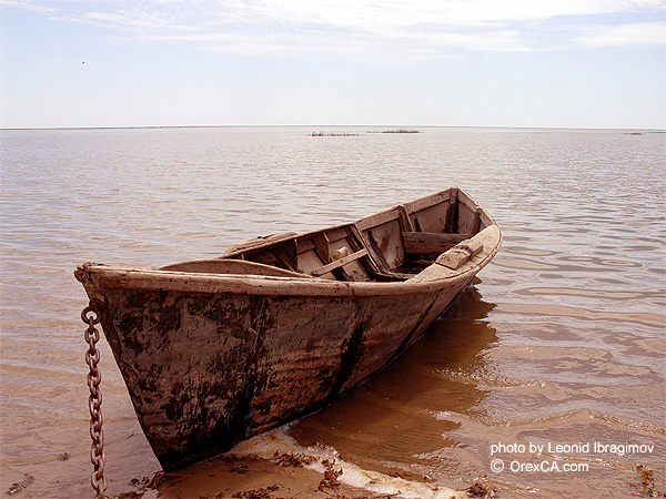
13. There are hundreds of ship skeletons on the former coastline.

14. Despite the vast drainage basin, the Aral Sea receives almost no water due to irrigation canals that take water from the Amu Darya and Syr Darya for hundreds of kilometers of their flow through the territory of several states. Among other consequences - the disappearance of many species of animals and plants.

15. Restoration of the entire Aral Sea is impossible. This would require a fourfold increase in the annual inflow of the Amudarya and Syrdarya compared to the current average of 13 km 3 . The only possible remedy would be to reduce the irrigation of the fields, which accounts for 92% of water withdrawals. However, four of the five former Soviet republics in the Aral Sea basin (with the exception of Kazakhstan) intend to increase their farmland irrigation, mainly to feed their growing population.

16. In this situation, switching to less moisture-loving crops, such as replacing cotton with winter wheat, would help, but the two main water-consuming countries in the region - Uzbekistan and Turkmenistan - intend to continue to grow cotton for sale abroad. It would also be possible to significantly improve the existing irrigation canals: many of them are ordinary trenches, through the walls of which a huge amount of water seeps and goes into the sand. The modernization of the entire irrigation system would help save about 12 km 3 of water annually, but would cost $16 billion.
However, if we turn to the history of the Aral, the sea has already dried up, while again returning to its former shores. So, what was the Aral Sea like for the last few centuries and how did its size change?

17. In the historical era, there were significant fluctuations in the level of the Aral Sea. So, on the retreating bottom, the remains of trees that grew in this place were found. In the middle of the Cenozoic era (21 million years ago), the Aral was connected to the Caspian. Until 1573, the Amu Darya flowed into the Caspian Sea along the Uzboy branch, and the Turgai River into the Aral. The map compiled by the Greek scientist Claudius Ptolemy (1800 years ago) shows the Aral and Caspian Seas, the Zarafshan and Amu Darya rivers flow into the Caspian.

18. At the end of the 16th and the beginning of the 17th century, the islands of Barsakelmes, Kaskakulan, Kozzetpes, Uyaly, Biyiktau, and Vozrozhdeniye were formed due to a drop in sea level. The rivers Zhanadarya since 1819, Kuandarya since 1823 ceased to flow into the Aral. From the beginning of systematic observations (XIX century) and until the middle of the XX century, the level of the Aral practically did not change. In the 1950s, the Aral Sea was the fourth largest lake in the world, occupying about 68 thousand km 2; its length was 426 km, width - 284 km, maximum depth - 68 m.

19. In the 1930s, large-scale construction of irrigation canals began in Central Asia, which was especially intensified in the early 1960s. Since the 1960s, the sea has become shallow due to the fact that the water of the rivers flowing into it has been diverted in increasing volumes for irrigation. From 1960 to 1990, the area of irrigated land in Central Asia increased from 4.5 million to 7 million hectares. The needs of the national economy of the region for water have increased from 60 to 120 km 3 per year, of which 90% is for irrigation.

20. Since 1961, the sea level has been decreasing at an increasing rate from 20 to 80-90 cm/year. Until the 1970s, 34 species of fish lived in the Aral Sea, of which more than 20 were of commercial importance. In 1946, 23 thousand tons of fish were caught in the Aral Sea, in the 1980s this figure reached 60 thousand tons. In the Kazakh part of the Aral Sea there were 5 fish factories, 1 fish cannery, 45 fish receiving points, in the Uzbek part (Republic of Karakalpakstan) - 5 fish factories, 1 fish canning factory, more than 20 fish receiving points.

21. The retreating sea left behind 54 thousand km 2 of dry seabed, covered with salt, and in some places also with deposits of pesticides and various other agricultural pesticides, once washed away by runoff from local fields.

22. Another very unusual problem is related to the island of Renaissance. When it was far away at sea, the Soviet Union used it as a testing ground for bacteriological weapons. The causative agents of anthrax, tularemia, brucellosis, plague, typhoid, smallpox, as well as botulinum toxin were tested here on horses, monkeys, sheep, donkeys and other laboratory animals. In 2001, as a result of water withdrawal, Vozrozhdeniye Island joined the mainland from the south side. Doctors fear that dangerous microorganisms have retained their viability, and infected rodents may become their distributors in other regions.