Mountains and their classification. What are folded mountains: examples. Mountain classification
- - Peaked mountain peaks;
- - Plateau-like mountain peaks;
- - Domed peaks mountains.
- - Mountain belts;
- - Mountainous countries;
- - Mountain systems;
- - Mountain ranges;
- - Mountain groups;
- - Solitary mountains.
Let's consider all the listed types and types of mountains in more detail.
Types and types of mountains in height:
The main feature by which mountains are classified is the height of the mountains. So, according to the height of the mountains there are:
Low mountains ( low mountains) - the height of the mountains is up to 800 meters above sea level.
Features of low mountains:
- The tops of the mountains are rounded, flat,
- The slopes are gentle, not steep, overgrown with forest,
- The presence of river valleys between the mountains is characteristic.
Examples: Northern Urals, spurs of the Tien Shan, some ranges of the Transcaucasia, Khibiny on Kola Peninsula, individual mountains of Central Europe.
Medium mountains (medium or medium altitude mountains) - the height of these mountains is from 800 to 3000 meters above sea level.
Features of the middle mountains:
- Medium-altitude mountains are characterized by high-altitude zonation, i.e. change of landscape with a change in height.
Examples of middle mountains: Mountains of the Middle Urals, Polar Urals, mountains of the island New earth, the mountains of Siberia and the Far East, the mountains of the Apennine and Iberian peninsulas, the Scandinavian mountains in northern Europe, the Appalachians in North America, etc.
More examples of middle mountains (added at the request of visitors):
- more than half of the territory Altai mountains(800-2000 meters),
- mid-mountain ranges of the Eastern Sayan Mountains,
- Aldan Highlands (height up to 2306 meters),
- medium-altitude ridges of the Chukotka Upland,
- the Orulgan ridge as part of the Verkhoyansk ridge (height - up to 2409 meters),
- Chersky ridge (the highest point is Mount Chingikan, 1644 meters high),
- Sikhote-Alin (the highest point is Mount Tordoki-Yani with a height of 2090 meters),
- High Tatras (Highest point - Mount Gerlachovsky Shtit, 2655 m),
- mid-mountain ranges of Transbaikalia (Daursky (up to 1526 m), Malkhansky (up to 1741 m), Dzhidinsky (up to 2027 m), Olekminsky Stanovik ( average height ridge - from 1000 to 1400 m, maximum - 1845 m), Vitim plateau (height from 1200 to 1600 m), etc.).
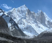
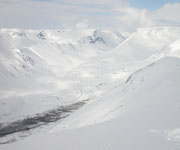
Highlands (high mountains) - the height of these mountains is more than 3000 meters above sea level. These are young mountains, the relief of which is intensively formed under the influence of external and internal processes.
Highlands features:
- The slopes of the mountains are steep, high,
- The peaks of the mountains are sharp, peaked, have a specific name - "carling",
- The ridges of the mountains are narrow, serrated,
- Altitudinal zonation is characteristic, from forests at the foot of the mountains to icy deserts at the tops.
Examples of highlands: Pamir, Tien Shan, Caucasus, Himalayas, Cordillera, Andes, Alps, Karakorum, Rocky mountains, etc.
Types and types of mountains by origin.
The next sign by which mountains are classified is their origin. So, by origin, mountains are tectonic, volcanic and erosional. (denudation):
 are formed as a result of the collision of moving parts of the earth's crust - lithospheric plates. This collision causes folds to form on the surface of the earth. This is how folded mountains
... When interacting with air, water and under the influence of glaciers, the layers of rocks that form folded mountains lose their plasticity, which leads to the formation of cracks and faults. At present, folded mountains in their original form have been preserved only in certain parts of the young mountains - the Himalayas, formed in the era of Alpine folding.
are formed as a result of the collision of moving parts of the earth's crust - lithospheric plates. This collision causes folds to form on the surface of the earth. This is how folded mountains
... When interacting with air, water and under the influence of glaciers, the layers of rocks that form folded mountains lose their plasticity, which leads to the formation of cracks and faults. At present, folded mountains in their original form have been preserved only in certain parts of the young mountains - the Himalayas, formed in the era of Alpine folding.
With repeated movements of the earth's crust, the hardened folds of the rock break into large blocks, which, under the influence of tectonic forces, rise or fall. This is how folded-block mountains... This type of mountains is typical for old (ancient) mountains. An example is the Altai mountains. The emergence of these mountains fell on the Baikal and Caledonian era mountain building, in the Hercynian and Mesozoic epochs, they underwent repeated movements of the earth's crust. Finally, the type of folded-block mountains was adopted during the Alpine folding.
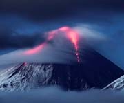 formed during volcanic eruptions. Are located, as a rule, along the fault lines of the earth's crust or at the boundaries lithospheric plates.
Volcanic there are mountains of two types:
Volcanic cones. These mountains acquired a cone-shaped appearance as a result of the eruption of magma through long cylindrical vents. This type of mountain is widespread throughout the world. These are Fujiyama in Japan, Mayon mountains in the Philippines, Popocatepetl in Mexico, Misty in Peru, Shasta in California, etc.
Shield volcanoes. Formed by repeated outpouring of lava. They differ from volcanic cones in their asymmetrical shape and small size.
In areas of the world where active volcanic activity occurs, whole chains of volcanoes can form. The most famous is the chain Hawaiian Islands of volcanic origin with a length of more than 1600 km. These islands are the tops of underwater volcanoes, the height of which is more than 5500 meters from the surface of the ocean floor.
 Erosional (denudation) mountains
.
Erosional (denudation) mountains
.
Erosional mountains have arisen as a result of intense dissection of stratal plains, plateaus and plateaus by flowing waters. Most mountains of this type are characterized by a table form and the presence of valleys between them of a box-like and sometimes canyon-like type. The latter type of valleys occurs most often when the lava plateau is dissected.
Examples of erosional (denudation) mountains are the mountains of the Central Siberian Plateau (Vilyui, Tunguska, Ilimsk, etc.). Most often, erosional mountains can be found not in the form of separate mountain systems, but within mountain ranges, where they are formed by the dissection of rock layers by mountain rivers.
Types and types of mountains according to the shape of the peaks.
Another sign of mountain classification is the shape of the summit.
By the nature of the vertex endings there are mountains: peaked, domed, plateau-shaped, etc.
Added at the request of visitors:
Peaked mountain peaks.
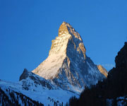 Peaked mountain peaks- these are peaked peaks of mountains, resembling peaks in shape, from which the name of this species came mountain peaks... They are inherent mainly in young mountains with steep rocky slopes, sharp ridges and deep crevices of river valleys.
Examples of mountains with peaked peaks:
Communism Peak (mountain system - Pamir, height 7495 meters)
Pobeda Peak (Tien Shan mountain system, height 7439 meters)
Mount Kazbek (mountain system - Pamir, height 7134 meters)
Pushkin Peak (mountain system - Caucasus, height 5100 meters)
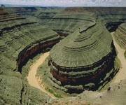
Plateau-like peaks of the mountains.
 The tops of mountains that are flat are called plateau-like.
Examples of plateau mountains:
Front ridge(eng. FrontRange) is a mountain range in the southern part of the Rocky Mountains in the United States, adjacent to the Great Plains in the west. The ridge stretches from south to north for 274 km. Highest point- Mount Grace Peak (4349 m). The ridge is composed mainly of granites. The peaks are plateau-like, the eastern slopes are gentle, the western ones are steep.
Khibiny(kild. Umptek) is the largest mountain range on the Kola Peninsula. The geological age is about 350 million years. The peaks are plateau-like, the slopes are steep with individual snowfields. At the same time, not a single glacier was found in the Khibiny. The highest point is Mount Yudychvumchorr (1200.6 m above sea level).
Ambas(translated from Amharic - Mountain Fortress) is the name of flat-topped hills and mesas in Ethiopia. They consist mainly of horizontally lying sandstones and basalt layers. This is what determines the flat-topped shape of the mountains. Ambas are located at an altitude of 4,500 m.
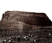 A variety of mountains with plateau-like peaks are the so-called mesas(it. Tafelberg, isp. Mesa- in the lane. table) - mountains with a truncated flat top. The flat top of these mountains is usually composed of a solid layer (limestone, sandstone, traps, hardened lava). The slopes of the mesas are usually steep or stepped. Mesa mountains arise when the flowing waters break up the stratal plains (for example, the Turgai plateau).
Notable mesas:
- Amba, (Ethiopia)
- Elbe Sandstone Mountains, (Germany)
- Lilienstein, (Germany)
- Buchberg, (Germany)
- Koenigstein, (Germany)
- Tafelberg (Thule), (Greenland)
- Ben Balben, (Ireland)
- Etjo, (Namibia)
- Gamsberg, (Namibia)
- Grootberg, (Namibia)
- Waterberg, (Namibia)
- Shchelinec Velikiy, (Poland)
- Kistenstöckli, (Switzerland)
- Tafelberg (Suriname)
- Tepui, (Brazil, Venezuela, Guyana)
- Monument Valley, (USA)
- Black Mesa (USA)
- Table Mountain, (South Africa)
- Dining room (mountain, Caucasus).
Domed mountain peaks.
 Dome-shaped, that is, rounded, the shape of the top can take:
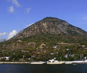
Laccoliths - unformed volcanoes in the form of a hill with a core of magma inside,
Extinct ancient heavily destroyed volcanoes,
Small areas of land that have undergone tectonic uplift of a domed nature and, under the influence of erosion processes, have taken on a mountainous image.
Examples of mountains with a domed top:
Black Hills (USA). This area has undergone a domed uplift, and most of the sedimentary cover was removed by further denudation and erosion. The central core was exposed as a result. It consists of metamorphic and igneous rocks.
Ay-Nikola(Ukr. Ai-Nіkola, Crimean cat. Ay Nikola, Ai Nikola) - a domed mountain-reject, southeastern spur of Mount Mogabi near the western outskirts of the village of Oreanda. It is composed of Upper Jurassic limestones. Height - 389 meters above sea level.
Castel(Ukrainian Kastel, Crimean cat. Qastel, Kastel) - mountain 439 m high on the southern outskirts of Alushta, behind the Professor's corner. The dome of the mountain is covered with a forest cap, and chaos has formed on the eastern slope - stone blocks, sometimes reaching 3-5 m in diameter.
Ayu-Dag or Bear Mountain(Ukrainian Ayu-Dag, Crimean Cat. Ayuv Dağ, Ayuv Dag) - a mountain on South Bank Crimea, located on the border of Big Alushta and Big Yalta. The height of the mountain is 577 meters above sea level. This is a classic example of laccolith.
Kara- Dag (Ukrainian Kara-Dag, Crimean Cat. Qara dağ, Qara dag) is a mountain-volcanic massif, Crimea. The maximum height is 577 m (Holy Mountain). It is a highly eroded volcanic form with a domed summit.
Mashuk- remnant magmatic mountain (mountain-laccolith) in the central part of Pyatigorye in the Caucasus Mineralnye Vody, in the northeastern part of the city of Pyatigorsk. Height 993.7 m. The top has a regular domed shape.
Types and types of mountains by geographic location.
The different types of mountains are separated and by geographic location... On this basis, it is customary to group mountains into mountain systems, ridges, mountain ranges and single mountains.
Let's take a closer look:
Mountain belts
- the largest formations. There are the Alpine-Himalayan mountain belt, stretching through Europe and Asia, and the Andean-Cordillera mountain belt, passing through the North and South America.Mountain country - many mountain systems.
Mountain system - mountain ranges and groups of mountains that are similar in origin and have the same age (for example, the Appalachians)
Mountain ranges - interconnected mountains, stretched in a line. For example, the Sangre de Cristo Mountains (North America).
Mountain groups - also interconnected mountains, but not elongated in a line, but forming a group of indefinite shape. For example, the Henry Mountains in Utah and Bare Poe in Montana.
Solitary mountains
Need more information? Use Google Search!
Selected world news.
Mountain systems cover about forty percent of the planet's surface: they can be seen on every continent, on many islands and on the ocean floor. Least of all the ridges are located on the Australian continent, and almost all the mountain ranges of Antarctica are safely hidden under the ice.
Mountains are a part of the earth's crust, which, as a result of the movement of tectonic plates, volcanic eruptions or other processes occurring inside the planet, rose to a considerable height and began to rise above the plains. The height of some heights is not great and is about three hundred meters, others rise more than eight thousand meters above. The type of mountains is extremely diverse: it can be like a separately located peak, or it can be the longest mountain ranges, which include hundreds and even thousands of cones.
Considering that the structure of the mountains consists of ten percent of sedimentary, and ninety percent of igneous and metamorphic rocks (appeared as a result of changes in the structure of sedimentary and volcanic rocks), geologists often find deposits of minerals inside them and under the mountain.
The relief of the mountains consists of several parts:
- Mountain (hill) - low or high mountain cone-shaped, consisting of the top, slopes and bottom (where the slopes merge with the surrounding area);
- The ridges are mountain heights that are strongly elongated in a line, the slopes of which, on the one hand, are often gentle, on the other, they are steep. They are also watersheds, as they direct river water flowing downhill from different sides of the slopes in opposite directions. For example, the Rocky Mountains are stretched from the north to southeast direction, while their length is about five thousand kilometers, thanks to which the Rocky Mountains are the watershed between the basins of the Pacific and Atlantic oceans;
- Saddle - a decrease in the relief between two hills located next to each other, usually the beginning of two hollows that go downhill in different directions;
- Hollow - an open, under a slight slope, a depression in the relief that lowers downhill, which below, when the slopes merge, forms a spillway line;
- Basin - located below sea level, a cone-shaped depression, which is characterized by the bottom, slopes and the edge line - the place where the slopes merge with the surface.
Formation theory
About how exactly the mountains of the world were formed, people throughout the history of their development put forward a variety of theories. At first, these were myths, legends and legends, then the versions began to be more substantiated. For example, it has been hypothesized that mountain systems arose from the movement of matter under the ocean floor, causing its surface to bend, which causes the crust to swell at the edges of the ocean.
This hypothesis did not explain in any way the presence of mountain systems inside the continent. Then they considered the version that the Earth is constantly decreasing in volume, and this happens in an abrupt manner and leads to deformation of the surface, where folds are formed, some of which rise above the surface, and the other goes downhill.
Later, the idea arose that the mountain system was formed during the continental drift. The idea was not bad, but it did not explain the reason for the movement of the continents, so it was forgotten. Instead, another hypothesis arose, suggesting that there are currents inside the Earth that cause the rise and fall (going downhill) of the earth's crust, affecting the relief of the planet. Despite the fact that many people liked the idea, no scientifically substantiated evidence was found to confirm it. 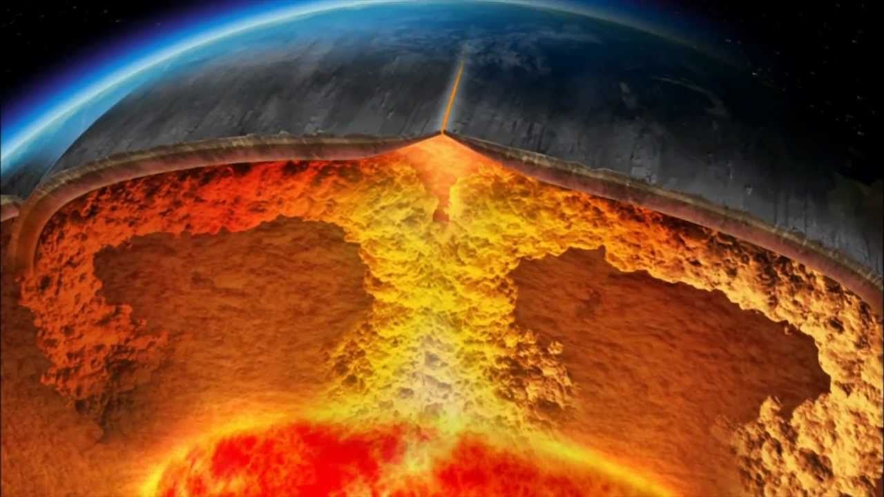
The modern hypothesis of the formation of mountains arose in the middle of the last century, when it was proved that during the collision of which a thinner plate goes under the neighboring one, forming hills on the earth's surface. This theory was combined with previous versions, it explained a lot and was accepted as the main one.
Age of mountains
Based on the theory of the movement of tectonic plates and soil analyzes, it was found that each mountain system was formed at one time. The age of the young ridges is from 50 to 80 million years, while the old mountain systems appeared more than a hundred million years ago (for comparison, the age of our planet is about four and a half billion years).
Young mountain ranges (Rocky Mountains, Himalayas) are interesting because their internal processes are still developing. For example, due to the constant collision of the Indian and Asian plates, the high mountains of the Himalayas grow by five centimeters per year. This process is always accompanied by earthquakes, and in some cases - volcanic eruptions. The young, growing mountain system is easily recognizable by the sharply delineated relief, consisting of alternating peaks and ledges, the sharp shape of the peaks, the presence of very steep and high slopes, which complicate both ascent and descent from the mountain.
The ancient mountain system differs from the younger one in that all processes inside it have long died down, while the external ones, causing erosion, continue to affect the surface of the Earth. Interesting fact: Geologists have discovered on the plains more than one area where a mountain system was previously located, of which only roots remained, reliably hidden under a thick layer of sedimentary rocks. The most ancient elevations of the Earth were recognized as the remnants of the mountains that are located in the Hudson Bay area: they appeared almost simultaneously with our planet. 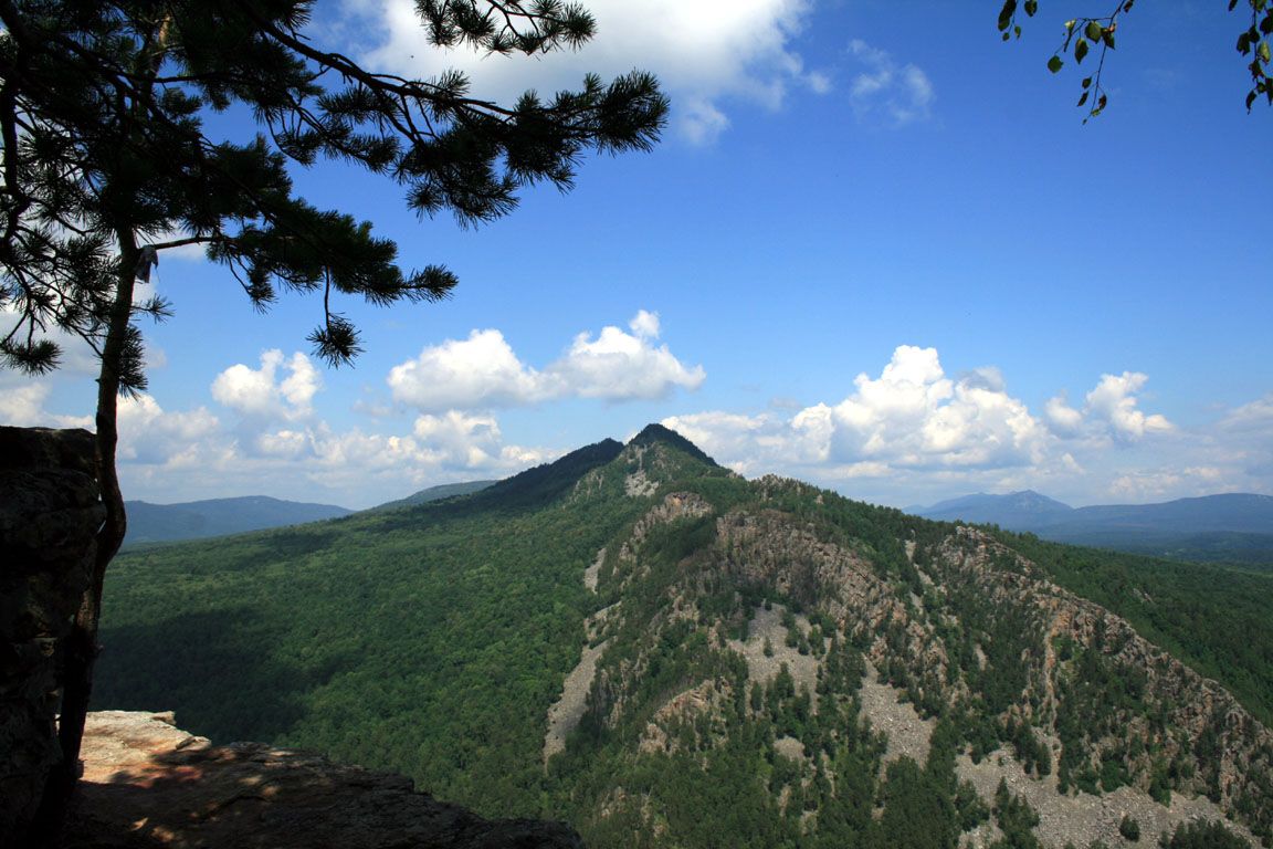
As for the ancient mountains, which time has not erased from the face of the Earth (for example, the Ural or Scandinavian), they can be recognized primarily by their height, not exceeding one and a half thousand meters, gentle slopes, and also by strong erosion. If in the young mountains water streams flow in narrow gorges, then the rivers of the old mountain flow along a well-defined wide river valley.
It is not uncommon for older mountain ranges to include young formations. For example, the Rocky Mountains, which appeared as a result of a tectonic shift from 80 to 50 million years ago, are the youngest part of the Western Cordilleras, which began to form more than 120 million years ago. It should be noted that the Rocky Mountains are still growing, so earthquakes and post-volcanic phenomena are frequent in the region where they are located.
Types of mountains
The answer to the question of what kind of mountains there are is not as simple as it seems: mountain ranges differ not only in age, but also in structure, origin, shape, location, height:
- In height - for low mountains, the height is up to 800 meters, for middle mountains - up to 3 thousand meters and in high mountains - more than 3 thousand meters. In some cases, the height of the mountains can reach incredible proportions. For example, which for a long period was listed in reference books as the highest mountain in the world, is almost nine kilometers. Recently, this primacy was called into question when, was discovered big mountain exceeding the size of Chomolungma: the height of the inactive volcano Mauna Kea from the base to the top exceeds ten kilometers.
- By origin - volcanic, tectonic or erosional (erosion of the plains by strong river flows, for example, canyons and mesas composed of limestone, basalt, sandstone).
- Along the top - a young high mountain usually has a spiky, pointed shape. The top of the mountain can have a plateau-like, dome-shaped or rounded shape, which is typical for both old, badly destroyed volcanoes, and for areas where a large mountain appeared as a result of plate collisions.
Zoning
If the elevation itself is not high, then the nature of the mountain at its base and at the top is not particularly different. True, this largely depends on which group of altitudinal zonality it belongs to. For example, the characteristic of mountains of the continental type implies the complete absence of forests.
But when describing the low and medium elevations of the coastal type, one cannot fail to mention the presence of a forest landscape and meadows. If we are talking about a mountain with a height of more than three thousand meters, it is worth considering: in order to climb to its top, it is necessary to overcome absolutely all the belts of our planet. Therefore, the weather in the mountains differs significantly from the climate of the plains near them.
This is due to the fact that temperature indicators decrease by six degrees with each kilometer traveled. In addition, atmospheric pressure decreases, the level of solar radiation rises and the amount of precipitation changes. Accordingly, such weather in the mountains also affects nature.
How many belts a high mountain will have depends largely on what climatic zone it is in (mountain ranges in the equatorial region have the largest number of zonal belts). It is also important at what height these zones will be located, how the slopes are located: on the sunny side, they are usually lower. Geologists divide altitudinal belts into several parts.
Nival high-rise belt
Only a high mountain can boast of the presence of a nival belt: in the tropics, it begins at an altitude exceeding 6.5 km above sea level. m., the farther north it is, the lower it is located (lifting and descending from the mountain is quite difficult and often fraught with death).
This zone is characterized by the presence of glaciers and eternal snow (the Rocky Mountains or the Himalayas, which include the highest mountain in the world, Everest), while the surface, not covered with snow, is subject to severe erosion, primarily weathering. The vegetation here is extremely sparse - lichens and a few grasses. There are also few animals: sometimes predators wander here, there are rodents, birds fly in and you can see some types of insects. 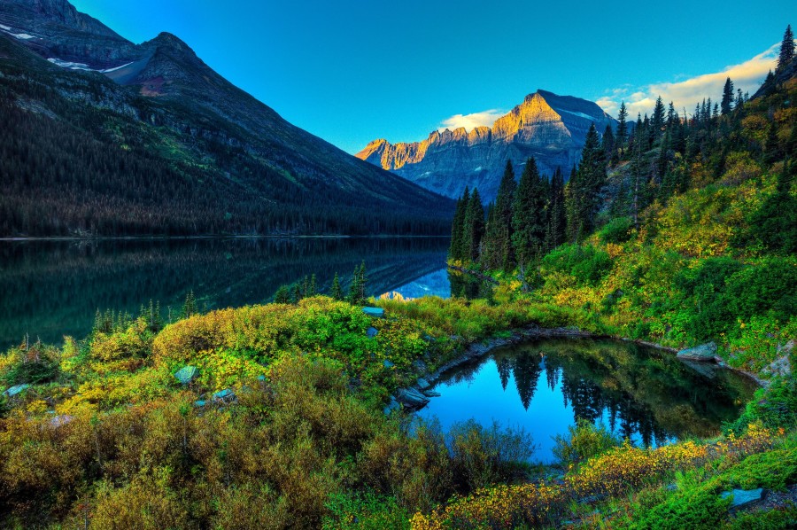
Mountain-tundra high-altitude belt
Winter in the mountain tundra zone is long, summer is short and cold. Average temperature indicators do not exceed + 9 ° С. A strong wind constantly blows here, and the ground often freezes (only lichens, mosses, low shrubs grow). This belt is not typical for all mountains: it is absent in warm latitudes; instead, an alpine or subalpine belt is located at this level.
Alpine high-altitude belt
The alpine belt is characteristic of the seaside type mountains, and almost never occurs in sharply continental latitudes. In the Himalayas, it is located at an altitude exceeding 3.6 kilometers, in the Alps and Andes - 2.2 kilometers. In the short summer, meadows bloom abundantly here, but winter is long and the slopes are completely covered with snow.
Desert-steppe belt
It is characteristic of the mountains that are located in desert and semi-desert areas of tropical latitudes and temperate zones. In drier areas it is located above the subalpine belt, in more humid areas - above the mountain-forest. The landscape of this zone is first characterized by the presence of steppe, then semi-desert and desert.
Subalpine high-altitude belt
In this zone, meadows are mixed with small areas of forests. Sometimes geologists combine this zone with the alpine and call it a mountain-meadow belt. 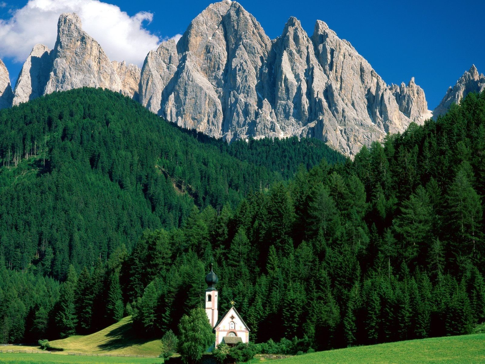
Mountain-forest high-altitude belt
The mountain-forest belt is characterized by the presence of forest landscapes, while the vegetation here is extremely abundant and all its types largely depend on the latitude where the mountain is located. This belt goes downhill.
Man's life in the mountains
Despite the fact that people settle mainly in the lowlands, at the base of the mountain, they have long ago learned to benefit from almost the entire mountain surface and learn to make the most of relatively small spaces. For example, in the Alps (the highest mountain is Mont Blanc with a height of 4810 m) at the foot of the mountain you can often see grape and garden plots, the middle part is sown with agricultural crops, and livestock graze in alpine meadows.
In the same mountains, thanks to the large amount of minerals, salt and precious metals, the mining industry is developed, paper and cellulose are harvested from the forest, hydroelectric power plants were built on the banks of the rivers.
It is also actively used by people and mountains located on the American continent. A striking example is the Rocky Mountains (the largest mountain in the ridge is Elbert with a height of 4.4 km). The Rocky Mountains hide huge reserves of coal, lead, zinc, silver, shale, oil and natural gas in their depths. Despite the fact that there are relatively few people living here (four people per square kilometer, and the population of only a few cities exceeds fifty thousand),
The Rocky Mountains have extremely developed agriculture and forestry. Americans and Canadians have successfully used mountain lands for grazing livestock and for growing crops.
The Rocky Mountains in our time are an extremely popular place among tourists: there are a huge number of national parks, among them - Yellowstone, famous for its geysers and geothermal springs.
Goals:
- To acquaint students with the concept of "mountains", their main types.
- Continue to develop the ability to work with maps, paintings and other sources of geographic information.
- To form social competences: love for nature, respect for it.
Equipment: physical map world, pictures of mountains, poems about mountains, recording of V. Vysotsky's songs about mountains, a fragment of the film "Vertical", presentation, screen, projector, laptop.
Lesson type: learning new material.
Methods:
- partial search,
- explanatory and illustrative.
During the classes
In the last lesson, we finished studying one of the sections of physical geography - "Geographic map".
Today we proceed to the next section - “The relief of the earth”.
Write down the topic of the lesson - “The relief of the Earth. The mountains". (slide number 1)
In elementary school, you studied the subject "The World Around" and met with the concept - "relief". Remember please - what is relief?
The guys answer: "the relief is all the irregularities of the earth's surface." (slide number 2) Write this definition in a notebook.
BUT remember please, what are the main 2 landforms you know?
The guys answer - mountains and plains.
Quite right.
Write in a notebook: (slide number 3)

So our today's lesson is dedicated specifically to the Mountains. For each person, the mountains are presented differently, but for everyone it is an object of admiration.
Watch carefully the video fragment from the feature film "Vertical", listen to the song that sounds in the film, think- Why am I showing you this fragment, with the help of what phrases does the author convey his attitude to the mountains? (slide number 4)
Here's what the guys should answer: (slide number 5)
Below you will not find 10 shares of such miracles
The heart is ready for the top to run from the chest
The whole world is in the palm of your hand, you are happy and mute, and you only envy those who have peaks yet to come
Sometimes rock climbers, climbers of the peaks, are asked why they are so drawn to the mountains, because on the peaks even in summer it is 20-30 degrees?
To which they answer - "Take a trip yourself at least once, then you will understand."
It is difficult to disagree with the statement “Mountains are the decoration of the Earth, it is worth for a minute to“ remove ”the mountains with the mind's eye, and the Earth will appear dull and meager, as if a solemn outfit had been torn from it”.
The purpose of our lesson
- get to know the concept of "mountains"
- learn the main types of mountains
- find out what the meaning of the mountains is
So let's start in order.
Let's write down 2 definitions of mountains that you need to know well.
Mountains are large areas of land that rise high above sea level and where there are sharp fluctuations in altitude.
Mountains are a convex shape of the earth's surface with a well-defined peak, slope and bottom. (slide number 6)
Who can draw a picture of a mountain and sign all of its parts? The student goes out and draws.

(slide number 7)
And what other form of relief does the drawing look like? - The guys answer that it's up the hill.
And what is the difference between a mountain and a hill? - (slide number 8)
What do you think, is it possible to find out the height of the mountains from the map? - The guys answer that yes, you can. But as? - on a scale of heights and marks of heights. Let's open a map of the hemispheres. Tell me, looking at it - what conclusion can be drawn about the height of the mountains? - The height of the mountains is different.
Let's take a look at the types of mountains by height. Write it down in the middle of the page
Classification of mountains by height (slide number 9, 10)
Name the highest mountains in the world.
Himalayas
Caucasus - show them on the map! Who can?
What is the highest peak in the world? - Everest = Chomolungma = “mother of the gods” = 8848 m. Write it down in a notebook. Look at the photo. (slide number 11)
And what is the most high peak in Russia? - Elbrus = “high mountain”, “sparkling, shiny”, “iron” = 5642 m. Write down and see the photo. (slide number 12)
And in what mountains is this peak? Who will show? - in the Caucasus.
We also live in the mountains. Who can show on the map? What type of height would you classify them to? - medium and low. Let's write it down in a notebook. What other examples can you give? - Scandinavian - low. Crimean - medium. Who will show?
There are many poems dedicated to the mountains. (slide number 13)
Lermontov writes -
In the distance I saw through the fog
In the snows burning like a diamond
Gray-haired, unshakable, Caucasus
And it was to my heart
Easy, I don't know why
Radkevich writes -
In every pine tree the heart is recognized
Tell me gray Ural
Where, in what heroic smithy
Have you forged your nature?
Tell me guys, who is right - Lermontov or Radkevich? They both call the mountains gray-haired -1 in their poems. - Caucasus. 2.-Ural. Who is right?
The guys talk, come to the conclusion that the Urals are older.
What does this mean? - That the mountains differ not only in height, but also in age. Let's write down
Mountain classification by age (slide number 14.15)
Let's take a look at the difference between old and young mountains. Open the tutorial - fig. 35-36 pp. 54- 55. Let's answer the questions of the table that you have on your tables looking at these figures.
Mountains are rarely solitary. They form mountainous countries. Let's write the definition
“Mountain countries - it is an alternation of mountains and intermountain depressions (valleys) ”. (slide number 16)

(slide number 17)
"Deep, narrow valleys with steep slopes - canyons, gorges" (slide number 18)
Lermontov - “Close and stuffy
In a wild gorge
The sun is not shining
The sky is barely visible ”(slide number 19)
And what is the difference between a canyon and a gorge? - the bottom of the gorge is wider. Although in Russia the term canyon is not used, we all call it gorges. And in the USA - a canyon.
We got acquainted with the concept of "mountains", their types, let's analyze - and what is the meaning of mountains? And we will write it down. (slide number 20)
- Mining
- Ski resorts
- Construction of hydroelectric power plants on mountain rivers
- Sheep pasture
- Inspiration for poets, artists
- Sacred territories (slide number 21-24)
So, today we have learned a lot about the mountains. What conclusions can be drawn on the topic of the lesson?
Mountains are the main form of relief
Mountains - varied
Mountains are of great importance
- Tell me, what are “mountains”?
- What are the mountains in height, give examples, show them on the map?
- What are the age?
Lesson grades ... ..
Write down S / P - (slide number 25)
- learn the synopsis.
- apply to / to the mountains. Signing as in the atlas. The list is at the platoon lock.
- be able to show mountains on the map.
I would like to finish our lesson with one more song by Vysotsky. Now I think you will perceive it differently.
It is a sharp rise among the rest of the territory, with significant differences in altitude - up to several kilometers. Sometimes the mountains have a fairly clear line of the sole at the slope, but more often the foothills.
It is very easy to find folded mountains on the map, because mountains as such are everywhere, on absolutely all continents and even on every island. Somewhere there are more of them, somewhere - less, as, for example, in Australia. In Antarctica, they are hidden by an ice layer. The highest (and youngest) mountain system is the Himalayas, the longest is the Andes, which stretch across South America for seven and a half thousand kilometers.
How old are the mountains
Mountains are like people, they can also be young, mature and old. But if people are younger, the smoother, then in the mountains the opposite is true: a sharp relief and high heights indicate a young age.
The old mountains and the relief are worn out, smoothed, and the heights are not with such large differences. For example, the Pamirs are young mountains, and the Ural mountains are old, any map will show that.
Relief characteristics
Folded mountains have an integral structure, but for the most detailed inspection you need to know the principles by which general characteristics relief. This applies not only but also literally meter deviations from the state of flat lands - this is the so-called mountain microrelief. The ability to classify correctly depends on the exact knowledge of what kind of mountains there are.
Here it is necessary to consider such elements as foothills, valleys, slopes, moraines, passes, ridges, peaks, glaciers and many others, since there are a wide variety of mountains on earth, including folded mountains.

Mountain classification by height
The height can be classified very simply - there are only three groups:
- Low mountains with a height of no more than a kilometer. Most often these are old mountains, destroyed by time, or very young, gradually growing. They have rounded tops, gentle slopes, on which trees grow. There are such mountains on every continent.
- Middle mountains in height from one thousand to three thousand meters. Here is another, changing landscape, depending on the height - the so-called altitudinal zonation. Such mountains are found in Siberia and the Far East, in the Apennine and Iberian peninsulas, Scandinavian, Appalachian and many others.
- Highlands- more than three thousand meters. These are always young mountains, subject to weathering, the effects of temperature changes and the growth of glaciers. Characteristic features: troughs - trough-like valleys, carlings - sharp peaks, glacial circuses - bowl-like depressions on the slopes. Here the altitude is marked by belts - a forest at the foothills, icy deserts closer to the peaks. The term summarizing these characteristics is "alpine landscape". The Alps are a very young mountain system, like the Himalayas, Karakorum, Andes, Rocky and other folded mountains.

Classification of mountains by geographic location
The geographical position divides the relief into systems, mountain groups, mountain ranges and single mountains. The largest formations are mountain belts: the Alpine-Himalayan - across the whole of Eurasia, the Andean-Cordillera - across both Americas.
A little smaller is a mountainous country, that is, many united mountain systems. In turn, the mountain system consists of groups of mountains and ridges of the same age, most often these are folded mountains. Examples: Appalachians, Sangre de Cristo.
![]()
A group of mountains differs from a ridge in that it does not build its peaks in a narrow long strip. Solitary mountains are most often of volcanic origin. In appearance, the peaks are divided into peak-like, plateau-like, domed and some others. Seamounts can form islands with their tops.
Mountain formation
Orogenesis is the most complex of the processes, as a result of which rocks are crumpled into folds. Scientists know for certain what folded mountains are, but only hypotheses are considered how they appeared.
- The first hypothesis is oceanic troughs. The map clearly shows that all mountain systems are located on the outskirts of the continents. This means that the continental rocks are lighter than the bottom rocks of the ocean. Movements inside the Earth seem to squeeze the continent out of its insides, and folded mountains are bottom surfaces that have come out onto land. This theory has many opponents. For example, folded mountains are the Himalayas, which are clearly not bottom, since they are located on the mainland itself. And according to this hypothesis, it is impossible to explain the existence of depressions - geosynclinal troughs.
- Leopold Kober hypothesis, who studied the geological structure of his native Alps. These young mountains have not yet undergone destructive processes. It turned out that tectonic large thrusts were formed by huge strata of sedimentary rocks. Alpine mountains clarified their origin, but this path is absolutely not similar to the emergence of other mountains, it was not possible to apply this theory anywhere else.
- Continental drift- a very popular theory, also criticized as not explaining the entire process of orogenesis.
- Subcortical currents in the bowels of the Earth they cause deformation of the surface and form mountains. However, this hypothesis has not been proven either. On the contrary, humanity does not yet know even such parameters as the temperature of the earth's interior, and even more so - the viscosity, fluidity and crystal structure of deep rocks, compressive strength, and so on.
- Earth compression hypothesis- with its own advantages and disadvantages. We do not know whether the planet accumulates heat or loses it, if it loses it - this theory is consistent, if it accumulates it - no.

What are the mountains
All kinds of sedimentary rocks accumulated in the troughs of the earth's crust, which then crumpled and, with the help of volcanic activity, folded mountains were formed. Examples: Appalachian east coast North America, Zagros mountains in Turkey.
Blocky mountains appeared due to tectonic uplifts along faults in the earth's crust. As, for example, California - Sierra Levada. But sometimes the already formed folded ones suddenly begin to rise along the fault. This is how folded-block mountains are formed. The most typical are the Appalachians.
Those mountains that were formed as folded strata of rocks, but were broken by young faults into blocks and rose to different heights, are also folded-block. The Tien Shan mountains, for example, as well as the Altai.
The Vaulted Mountains are a domed tectonic uplift plus erosion processes over a small area. These are the mountains of the Lake District in England, as well as the Black Hills, located in South Dakota.
Volcanic ones were formed under the influence of lava. There are two types of them: volcanic cones (Fujiyama and others like them) and shield volcanoes (less tall and not so symmetrical).

Mountain climate
The mountainous climate is fundamentally different from the climate of any other territories. Temperatures drop by more than half a degree for every hundred meters of altitude. The wind is also usually very cold, which is facilitated by cloudiness. Frequent hurricanes.
With the climb, the atmospheric pressure also decreases. On Everest, for example, up to 250 millimeters of mercury. Water boils at eighty-six degrees.
The higher, the less vegetation cover, until it is completely absent, and life is almost completely absent in glaciers and on snow caps.

Linear zones
Thanks to fault-tectonic analysis, it was possible to draw up a definition of what fold mountains are, as a result of which they were formed and how dependent on deep planetary faults. All - both ancient and modern - mountain areas are included in certain linear zones, which were formed in only two directions - northwest and northeast, repeating the direction of deep faults.
These belts are bordered by platforms. There is a dependence: the platform changes the position and shape, and the external forms and orientation in the space of the folded belts change. During the formation of mountains, everything is decided by fault tectonics (blocks) of the crystalline base. The vertical movements of the foundation blocks form folded mountains.
Examples of the Carpathians or Verkhoyansk-Chukotka region show Various types tectonic movements during the formation of mountain folds. The Zagros Mountains also emerged in the same way.

Geological structure
Everything in the mountains is diverse - from structure to structure. for example, the same Rocky Mountains change along their entire length. In the northern part - Paleozoic shales and limestones, further - closer to Colorado - granites, igneous rocks with Mesozoic sediments. Even further, in the central part, there are volcanic rocks, which are absent at all in the northern areas. The same picture will appear if we consider the geological structure of many other mountain ranges.
They say that there are no two identical mountains, but volcanic massifs, for example, often have a number of similar features. The correctness of the outlines of the cone of Japanese and Philippine volcanoes, for example. But if we start a detailed geological analysis now, we will see that the saying is quite right. Many volcanoes in Japan are composed of andesites (magma), and the Philippine rocks are basaltic, which is much heavier due to the high iron content. And the Oregon Cascade Mountains folded their volcanoes with rhyolite (silica).

Time of formation of folded mountains
The formation of mountains in the entire process occurred due to the development of geosynclines in different geological periods, even in the era of folding up to the Cambrian. But only young (comparatively, of course) - Cenozoic uplifts belong to the modern mountains. The older mountains were leveled long ago and were raised again by new tectonic movements in the form of blocks and arches.
The vaulted block mountains are most often revived. They are as common as the younger, folded ones. Today's is neotectonics. It is possible to study the folding that formed tectonic structures if we consider the difference in the age of the mountains, and not the relief created by it. If the Cenozoic is recent, then it is difficult to think about the age of the very first mountain formations.
And only volcanic mountains can grow right before our eyes - during the entire eruption. Eruptions most often occur in the same place, so each portion of lava builds up the mountain. In the center of the mainland, a volcano is a rarity. They tend to form whole underwater islands, often forming arcs several thousand kilometers long.

How mountains die
The mountains could stand forever. But they are being killed, albeit slowly when compared to human life. This is, first of all, frosts, splitting the rock into small pieces. This is how taluses are formed, which are then carried down by snow or ice, building moraine ridges. It is water - rain, snow, hail - that makes its way even through such indestructible walls. The water is collected in the rivers, which make themselves winding between the mountain spurs of the valley. The history of the destruction of unshakable mountains, of course, is long, but inevitable. And the glaciers! Whole spurs, it happens, are cleanly cut off by them.
Such erosion gradually lowers the mountains, turning them into a plain: somewhere green, with full-flowing rivers, somewhere deserted, grinding all the remaining hills with sand. This surface of the Earth is called "peneplain" - almost a plain. And, I must say, this stage occurs extremely rarely. The mountains are reborn! Earth's crust begins to move again, the terrain rises, starting a new phase of relief development.