Nevada nuclear testing site. Nevada polygons. Excerpt describing the Nevada Test Site
On February 6, 1951, a 22-kiloton bomb was detonated at the largest American nuclear test site, located in Nevada, just 100 kilometers from Las Vegas. The nuclear “mushroom” grew to a height of 437 meters in a matter of minutes. This was the last and most powerful test (dubbed Fox) of Operation Ranger.
This operation itself was the first for the Nevada test site, the area of which was about 3.5 thousand square kilometers. Today, tests are no longer carried out here, since on October 1, 1992, US President George H. W. Bush declared a moratorium on them. Although the test site is considered to be still operational, they even planned to explode a non-nuclear projectile here in 2006, but then the idea was abandoned. Today, this desert area is dotted with craters left by underground explosions. They even organize tours here, but curious guests are prohibited from taking filming equipment and binoculars with them.
Over more than 40 years of history, over 900 explosions have been carried out in this desert. “RG” recalls the most powerful of them: guests of the “city of sin” could observe how nuclear mushrooms grew from the windows of their hotels. And some of them even went closer to the epicenter of the grandiose event, since the Americans were announced about the explosions in advance. This is how “nuclear tourism” arose in the United States; few people then knew about the radioactive consequences of such curiosity.
October-November 1951 - Operation Buster-Jangle
On November 5, a bomb (Easy test) with a yield of 31 kilotons was dropped into the Nevada wasteland from the first American B-45 jet bomber from an altitude of about 400 meters. The three previous shells were also dropped from an aircraft, a B50 heavy bomber. During this series of explosions in Nevada, military and scientists wanted to test the effect of nuclear strikes on various objects - plants, animals, and clothing. 6.5 thousand soldiers were involved in the operation. Some of them were only six miles from the epicenter of another bomb (the 21-kiloton Dog) of Operation Buster-Jangle.
March-June 1953 - Operation Upshot-Knothole
During this series, three of the most powerful explosions occurred in the Nevada desert: April 25 - Simon tests (43 kilotons), May 19 - Harry (32 kilotons) and June 4 - Climax (61 kilotons). The last two deserve special mention. During the Harry explosion, the Hamlet nuclear charge, developed by one of the leading American creators of nuclear and thermonuclear charges, Ted Taylor, was tested at Los Alamos. Here, for the first time, the so-called “hollow core” was used, which was supposed to increase the efficiency of the explosion. Hamlet was also supposed to be the cleanest charge with an energy release of up to 100 kilotons. Early on a May morning, a bomb was detonated on a 90-meter steel tower. However, the test led to large-scale radioactive contamination of the continental United States, which caused great resonance in society and the media. The explosion eventually earned the nickname "Dirty Harry".
And the Climax test was carried out with the help of the American intercontinental bomber Convair B-36, from which a 61-kiloton bomb was dropped on the test site in early June from an altitude of 406 meters. It is noteworthy that the unofficial name of the bomber is “Peacemaker”. This is the largest combat aircraft in the history of aviation in terms of wingspan and height. It was intended to bomb Germany from US territory in the event that Great Britain surrendered to the mercy of the Germans. By the start of the Cold War, the B-36 became the backbone of the US strategic nuclear force, as the aircraft could deliver nuclear bombs to targets inside the USSR.
It is necessary to mention two more explosions in this series. During the Grable test (May 25), nuclear artillery was used for the first time - a 15-kiloton projectile was fired by a 280-millimeter atomic cannon. Another nuclear explosion, Annie, with a yield of 16 kilotons, made on March 17, was shown on one of the television channels. At the site they built two frame houses, eight typical urban bomb shelters and placed 50 cars. The Ministry of Civil Defense checked the safety of being in a car during an explosion and the protective capabilities of wooden buildings. Military officials assumed that at a distance of 1,200 meters from the epicenter a person could survive in an ordinary house, and at a distance of 2.5 kilometers the supporting structures would not even be damaged. And they turned out to be right: as a result of the test, both buildings confirmed the safety calculations.
February-May 1955 - Operation Teapot
The two most powerful explosions of this series took place on March 7 (Turk - 43 kilotons) and May 5 (Apple-2 - 29 kilotons). Moreover, with the help of the second, the military wanted to test the strength of buildings made of various materials. Some of the buildings still remain on the territory of the first nuclear test site in Nevada. A documentary film was made about this explosion, which shows how a nuclear wave sweeps away houses, although in the film the operation is called “Cue”. Later, some footage was used in the 1983 film “The Next Day.”
On July 6, an explosion occurred with a yield of 104 kilotons, called Sedan. It was one of the most spectacular, albeit underground, nuclear tests. As foreign researchers write, it was carried out under the auspices of a program for the non-military use of nuclear explosions. The goal is to analyze the potential of "clean" thermonuclear installations for creating cheap craters during the construction of canals or harbors. The explosion formed a crater with a diameter of 390 meters and a depth of? 100 meters.
And on July 17 of the same year, as part of Operation Sunbeam, the last atmospheric nuclear explosion in Nevada occurred. After the treaty banning nuclear weapons testing in the atomosphere, outer space and under water was signed, all explosions at the Nevada test site were carried out only underground. Today in the desert you can see huge craters - monuments to the "arms race" - which could fit high-rise buildings. In total, 828 underground explosions thundered among the sands.
It consisted of eight explosions, the power of two of which - Lubbock (October 18, 1991) and Junction (March 26, 1992) could be up to 150 kilotons. And the last nuclear test in the history of this test site and the United States as a whole was the explosion on September 23 of a Divider projectile with a yield of less than 20 kilotons. Officially, its purpose was to test “the security of American deterrent forces.”
Coordinates: 37°07′ N. w. 116°03′w. d. / 37.117° N. w. 116.050° W d. / 37.117; -116.050 (G) (I) near Las VegasUSA USA
Location of the landfill.

 Nevada Proving Ground(English) Nevada Test Site listen)) - one of the largest nuclear test sites in the United States, existing since 1951. Previously called Nevada Proving Ground. The territory of the test site is about 3500 km², 928 nuclear explosions were carried out there. The very first explosion with a power of 1 kiloton was carried out on January 27, 1951.
Geographical data
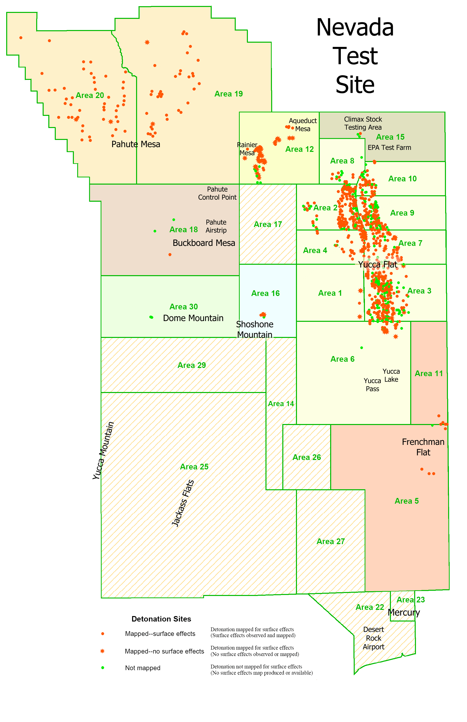
The test site occupies 3500 km². Its territory is divided into 28 parts, on which there are 1000 buildings, 2 runways, 10 helipads.
History of the test site
The first nuclear explosion at this test site was carried out on January 27, 1951. The bomb's yield was 1 kiloton. The creation of the test site was part of the atomic project and the choice was made, as it turned out later, very successfully - the terrain made it possible to carry out underground nuclear explosions both in adits and in wells.
1951-1992
On July 17, 1962, the Little Feller I explosion of Operation Sunbeam became the last atmospheric explosion at the Nevada nuclear test site.
Underground testing continued until September 23, 1992; explosions that do not reach critical mass continue to this day.
1992-2007
A conventional non-nuclear detonation of a very powerful 1,100-ton bomb was planned in 2006, but this project was officially canceled in 2007.
Current state
Survival studies
At the training ground, buildings typical of European and American cities are reproduced, various equipment and vehicles, and fortifications of both NATO and Warsaw Pact are located. All these objects were at different distances and at different angles to the explosion points.
High-speed cameras located in protected places recorded all the effects of blast waves, radiation, temperature and other consequences of nuclear explosions.
Test series of nuclear explosions at a nuclear test site in Nevada
|
|

see also
Write a review of the article "Nevada Proving Ground"
Notes
Links
- (PDF)
- , (1997)
- Cards:
Excerpt describing the Nevada Test Site
This is what the stories say, and all this is completely unfair, as anyone who wants to delve into the essence of the matter can easily see.The Russians could not find a better position; but, on the contrary, in their retreat they passed through many positions that were better than Borodino. They did not settle on any of these positions: both because Kutuzov did not want to accept a position that was not chosen by him, and because the demand for a people’s battle had not yet been expressed strongly enough, and because Miloradovich had not yet approached with the militia, and also because other reasons that are innumerable. The fact is that the previous positions were stronger and that the Borodino position (the one on which the battle was fought) is not only not strong, but for some reason is not at all a position any more than any other place in the Russian Empire, which, if you were guessing, you could point to with a pin on the map.
The Russians not only did not strengthen the position of the Borodino field to the left at right angles to the road (that is, the place where the battle took place), but never before August 25, 1812 did they think that the battle could take place at this place. This is evidenced, firstly, by the fact that not only on the 25th there were no fortifications at this place, but that, begun on the 25th, they were not finished even on the 26th; secondly, the proof is the position of the Shevardinsky redoubt: the Shevardinsky redoubt, ahead of the position at which the battle was decided, does not make any sense. Why was this redoubt fortified stronger than all other points? And why, defending it on the 24th until late at night, all efforts were exhausted and six thousand people were lost? To observe the enemy, a Cossack patrol was enough. Thirdly, proof that the position in which the battle took place was not foreseen and that the Shevardinsky redoubt was not the forward point of this position is the fact that Barclay de Tolly and Bagration until the 25th were convinced that the Shevardinsky redoubt was the left flank of the position and that Kutuzov himself, in his report, written in the heat of the moment after the battle, calls the Shevardinsky redoubt the left flank of the position. Much later, when reports about the Battle of Borodino were being written in the open, it was (probably to justify the mistakes of the commander-in-chief, who had to be infallible) that unfair and strange testimony was invented that the Shevardinsky redoubt served as a forward post (while it was only a fortified point of the left flank) and as if the Battle of Borodino was accepted by us in a fortified and pre-chosen position, whereas it took place in a completely unexpected and almost unfortified place.
The thing, obviously, was like this: the position was chosen along the Kolocha River, which crosses the main road not at a right angle, but at an acute angle, so that the left flank was in Shevardin, the right near the village of Novy and the center in Borodino, at the confluence of the Kolocha and Vo rivers yn. This position, under the cover of the Kolocha River, for an army whose goal is to stop the enemy moving along the Smolensk road to Moscow, is obvious to anyone who looks at the Borodino field, forgetting how the battle took place.
Napoleon, having gone to Valuev on the 24th, did not see (as they say in the stories) the position of the Russians from Utitsa to Borodin (he could not see this position, because it did not exist) and did not see the forward post of the Russian army, but stumbled upon the Russian rearguard in pursuit to the left flank of the Russian position, to the Shevardinsky redoubt, and, unexpectedly for the Russians, transferred troops through Kolocha. And the Russians, not having had time to engage in a general battle, retreated with their left wing from the position they had intended to occupy, and took up a new position, which was not foreseen and not fortified. Having moved to the left side of Kolocha, to the left of the road, Napoleon moved the entire future battle from right to left (from the Russian side) and transferred it to the field between Utitsa, Semenovsky and Borodin (to this field, which has nothing more advantageous for the position than any another field in Russia), and on this field the entire battle took place on the 26th. In rough form, the plan for the proposed battle and the battle that took place will be as follows:
If Napoleon had not left on the evening of the 24th for Kolocha and had not ordered an attack on the redoubt immediately in the evening, but had launched an attack the next day in the morning, then no one would have doubted that the Shevardinsky redoubt was the left flank of our position; and the battle would take place as we expected. In this case, we would probably defend the Shevardinsky redoubt, our left flank, even more stubbornly; Napoleon would have been attacked in the center or on the right, and on the 24th a general battle would have taken place in the position that was fortified and foreseen. But since the attack on our left flank took place in the evening, following the retreat of our rearguard, that is, immediately after the battle of Gridneva, and since the Russian military leaders did not want or did not have time to begin a general battle on the same evening of the 24th, Borodinsky’s first and main action The battle was lost on the 24th and, obviously, led to the loss of the one fought on the 26th.
After the loss of the Shevardinsky redoubt, by the morning of the 25th we found ourselves without a position on the left flank and were forced to bend back our left wing and hastily strengthen it anywhere.
But not only did the Russian troops stand only under the protection of weak, unfinished fortifications on August 26, but the disadvantage of this situation was increased by the fact that the Russian military leaders did not recognize the completely accomplished fact (the loss of position on the left flank and the transfer of the entire future battlefield from right to left ), remained in their extended position from the village of Novy to Utitsa and, as a result, had to move their troops during the battle from right to left. Thus, during the entire battle, the Russians had twice as weak forces against the entire French army directed at our left wing. (Poniatowski’s actions against Utitsa and Uvarov on the French right flank were actions separate from the course of the battle.)
So, the Battle of Borodino did not happen at all as they describe it (trying to hide the mistakes of our military leaders and, as a result, diminishing the glory of the Russian army and people). The Battle of Borodino did not take place in a chosen and fortified position with forces that were somewhat weaker on the Russian side, but the Battle of Borodino, due to the loss of the Shevardinsky redoubt, was accepted by the Russians in an open, almost unfortified area with forces twice as weak against the French, that is, in such conditions in which it was not only unthinkable to fight for ten hours and make the battle indecisive, but it was unthinkable to keep the army from complete defeat and flight for three hours.
The Nevada nuclear test site was created in 1951. Occupying an area of 3,500 square kilometers, the test site, in addition to the testing field, includes about a thousand buildings for various purposes and several airfields.
From 1951 to 1992, 928 (think about this number!) nuclear explosions were carried out at the Nevada Test Site, 828 of them underground. The nuclear mushrooms from the explosions were so huge that they were observed even in Los Angeles.


The last test in Nevada took place in 1992. Now the surface of the test site resembles the lunar one - a lifeless desert and numerous craters, like lunar craters. Some of these craters could easily fit a high-rise building. The largest crater is the Sedan crater, its depth is 100 meters, and its diameter is 400!

Source - Internet
17.01.2017, 15:00
Perhaps there is no area on the planet that can compare with the American state of Nevada in terms of the number and area of various types of military training grounds and testing centers. In the past, during the time of the USSR, the “Soviet Nevada” was the Kazakh SSR, but now most of the landfills in Kazakhstan have been liquidated.
The state of Nevada is located in the southwestern part of the United States, with an area of 286,367 km². It borders on California in the west, Oregon and Idaho in the north, and Utah and Arizona in the east. The bulk of Nevada is desert and mountains. The climate is sharply continental and arid - the average annual precipitation is about 180 mm. In the summer of 1994, the thermometer in the south of the state reached + 52 °C. Winters can be quite cold; in 1972, in the mountains in the northeast of the state, the temperature dropped below - 47 ° C. It is very difficult to conduct agricultural activities in such conditions, which is why more than 87% of the land is owned by the federal government.
Population density is low; as of mid-2004, Nevada had only 10 cities with populations of less than 10,000 people. However, in recent years there has been an increase in population, this trend is especially noticeable in the “gaming capital of the USA” – Las Vegas. The city's population has increased 25 times over 40 years and now amounts to more than 2.5 million people. At the same time, the total population of the state is about 2.8 million people. Nevada's population increase is largely due to illegal immigration. In 2012, US immigration officials estimated that the number of undocumented migrants (mostly Mexicans) accounted for almost 9% of the state's population (the highest figure in the US).

The use of Nevada's dry lands as military training grounds began in the 1930s. Artillery firing and practice bombing were carried out here, but this was sporadic. After the outbreak of World War II, the army needed vast areas for combat training and test firing. Beginning in mid-1941, the military used the area to conduct control and artillery training exercises and test new explosives and high-power ammunition.
Shortly after Operation Trinity on July 16, 1945, the first ever nuclear test explosion at the White Sands test site in the desert near the city of Alamogordo in New Mexico, the question arose of creating a permanent nuclear test site with the appropriate infrastructure. The White Sands test site was not very suitable for this, since it was located close to densely populated areas, in addition, ballistic missiles created in the United States were tested there since July 1945. Why were control and test benches, hangars for missile assembly, launch facilities and radars for trajectory measurements of missile flights built there?
While nuclear charges were “piecemeal goods,” they were tested in different parts of the United States and on the Pacific atolls of Bikini and Enewetak. However, atmospheric nuclear tests outside the United States with serious releases of radioactive fallout caused mass protests in other countries. The public in the countries of the Asia-Pacific region reacted especially sharply to this. In addition, on relatively small islands it was not possible to create a good scientific testing base. Maintaining the necessary infrastructure in a humid monsoon climate, delivering necessary cargo to remote areas and protecting the marine area was very expensive.
In 1951, it was decided to create a nuclear test site, the Nevada Test Site, 100 km north of Los Vegas, in Nye County, in the southern part of Nevada. As subsequent events showed, the location for the training ground was chosen very well. It is located at a considerable distance from densely populated areas, and the climate here is dry. The test site, with an area of about 3,500 km², had both absolutely flat areas and mountains. The soil structure turned out to be very suitable for underground testing in adits and boreholes. Delivery of goods to this area did not cause any difficulties. The territory of the landfill is divided into 28 sectors, where about 1000 buildings and structures were built at different times, there are 2 runways and 10 helipads.

The first atmospheric nuclear test of a 1 kt tactical charge took place on January 27, 1951. Soon, explosions began to thunder here regularly, as part of testing new types of strategic and tactical nuclear weapons and studying their damaging effects on equipment and structures.

It is not an exaggeration to say that in the 50-60s, at the Nevada test site there was the world's largest and best-equipped center for studying the damaging factors of nuclear weapons. For this purpose, units of the US Army Corps of Engineers built entire residential areas corresponding to the typical development of American and European cities. In addition to residential buildings, various fortifications were built; equipment and weapons were installed at different distances from the epicenter of the explosion, where experimental animals were placed. In addition, thousands of American military personnel participated in large-scale exercises using nuclear weapons, essentially becoming “guinea pigs.”

For example, during Operation Buster-Jangle, which took place from October 22 to November 29, 1951, more than 6,500 troops were involved. In a series of 7 tests, 5 bombs were dropped from B-50 and B-45 bombers. However, one, the very first bomb, did not explode. The power of the explosions ranged from 3.5 to 31 kt. Two more charges of 1.2 kt each were tested on the surface of the earth. During the 21 kt test, which took place on November 1, 1951, military personnel were openly positioned on the ground at a distance of 8-10 km from the epicenter.

Before the ban on atmospheric nuclear testing in 1962, about 100 charges were detonated in Nevada. The exact number of atmospheric tests is indicated differently in different sources. About a dozen tests in the atmosphere were unsuccessful when, due to automation failure or design errors, the nuclear reaction did not start, and charges with fissile radioactive substances were sprayed on the ground.

Atmospheric nuclear explosions have had a very significant radiation load on the US population. However, both in the USA and in the USSR in the 50-60s, radiation was treated quite frivolously. Some atmospheric nuclear tests were announced in advance, and crowds of tourists flocked to the border of the test site to admire the rare spectacle and take photographs with the “nuclear mushroom” in the background. Clouds formed after particularly powerful tests were visible even in Las Vegas.
After fairly miniature nuclear charges were developed in the United States, the American military began to prepare for their use directly on the battlefield. So, on May 25, 1953, an “atomic cannon” was fired at the test site for the first time in the history of mankind. A nuclear 280-mm artillery shell T-124 with a power of 15 kt exploded at an altitude of 160 meters above the ground, 19 seconds after it left the barrel of the M65 gun, flying more than 10 km.

Due to its excessive mass (weight in the stowed position is 75 tons) and dimensions, the M65 gun was produced in single copies. Subsequently, after the creation of even smaller charges, the 280 mm gun was supplanted by 155 and 203 mm towed and self-propelled artillery systems.
Standing apart from the series of American nuclear explosions is the test known as Storax Sedan. It was a “peaceful explosion” of a thermonuclear charge with a capacity of 104 kt of TNT, it was carried out as part of the Operation Plowshare research program. In the Soviet press the program was known as "Operation Plowshare". At the same time, both the USA and the USSR studied the possibility of creating underground cavities for storing gas and oil, as well as reservoirs, laying canals, crushing rock and mining minerals using nuclear charges.

The thermonuclear charge was lowered into the well to a depth of about 190 meters. As a result of the explosion, about 12 million tons of soil were raised to a height of 100 meters into the air. This created a crater 100 meters deep and more than 390 meters in diameter. The instruments recorded a seismic wave equivalent to an earthquake of magnitude 4.7.
The Storax Sedan explosion was the dirtiest nuclear test conducted on the continental United States. As a result of the explosion, about 7% of the total volume of radioactive fallout released into the atmosphere during nuclear tests at the Nevada test site was released. The radioactive emissions split into two clouds, rising to a height of 3 km and 5 km. The wind carried them to the northeast along parallel paths towards the Atlantic coast. Along the path of the clouds, significant radioactive fallout occurred. In the states of Iowa, Nebraska, South Dakota and Illinois, it was necessary to carry out partial evacuation of the population and introduce a regime of increased radiation danger.

The territory of the test site was subject to significant radiation contamination; being in this area immediately after the explosion was mortally dangerous. The radiation level near the crater an hour after the explosion was 500 R/h. A month after the short-lived isotopes, “hot” in terms of radioactivity, decayed, the radiation level dropped to 500 mR/h, and six months later at the bottom of the crater there was 35 mR/h. In 1990, radiation levels dropped to 50 microR/h.

Now an observation deck has been built on the edge of the crater and tourists are taken here for a lot of money. It was the largest “nuclear crater” in the United States and it stands out for its size in satellite images of the Nevada nuclear test site, which in places resembles a “lunar landscape.”
In order to visit the nuclear test site as part of an excursion group, you must submit an application to the test site administration. The line for the excursion is booked long in advance, and you will have to wait about a month. When visiting the test site, tourists are given dosimeters. At the same time, any photo or video equipment, cell phones and binoculars are confiscated. Without the permission of the accompanying persons, it is prohibited to leave the excursion bus and take any objects or stones from the site.

After July 17, 1962, until September 23, 1992, 828 charges were detonated underground at the test site. Some of the explosions were accidental, with significant releases of radioactive substances.

There are still several emergency nuclear charges left at the test site in underground wells that did not explode for one reason or another. After the comprehensive ban on nuclear testing, the site was not eliminated. Research is carried out here as part of the testing of existing types of nuclear warheads and the development of new ones without reaching a critical mass of charges and starting a large-scale uncontrollable chain reaction. Ten years ago, preparations were made for an experiment with the detonation of 1,100 tons of powerful explosives, but due to widespread criticism and fears that this test would lead to the start of similar experiments in other countries, the project was closed.

In addition to the nuclear test site, Nevada also has several aviation test centers and testing grounds for testing and testing the combat use of aircraft and missile weapons.

The most mysterious place in Nevada is the so-called Area 51, adjacent to the dry salt lake Groom Lake. In the 70s, this name of the base appeared in a number of official documents, after which information was leaked to the media. Also, at different times, the airbase had the following code designations: Dreamland, Paradise Ranch, Home Base, Groom Lake. Currently, the airfield in official American documents is referred to as Homey Airport (“Horney Airport”).

This military installation is a branch of Edwards Air Force Base, where the US Air Force Flight Test Center is located. The main runway of Area 51, more than 3.5 km long, smoothly transitions to a dry salt lake adjacent to the airfield. Thus, the perfectly flat surface of the salt lake is a continuation of the runway, the total length of which is about 8 km. Theoretically, even space shuttles could be landed on this strip.

Area 51 is adjacent to the nuclear test site and is located 130 km northwest of Las Vegas. The security regime for this area is even stricter than at the nuclear test site. There are practically no high-quality photographs of the Area 51 airfield in open sources. It is believed that in addition to numerous above-ground buildings, the base has extensive underground structures.
In the past, federal authorities have refused to comment at all on the site and, in some cases, have even denied the site's existence. This circumstance gave rise to many rumors and various kinds of legends. Conspiracy theorists believe that Area 51 is hiding the wreckage of an interstellar spaceship and even aliens from the public. This was the reason for all sorts of rumors and speculation, which was reflected in many publications and in science fiction feature films.
In reality, such strict secrecy measures were associated with the testing of new types of aircraft in this area. Objects identified by outside observers as UFOs have been repeatedly recorded in this area. Thus, the appearance of the so-called “Black Triangles” coincided with the testing of aircraft created under the low radar signature program. Large-scale research into technologies that allow American combat aircraft to be invisible in the radar range began in the late 70s. For more than fifteen years, all military programs in the United States related to Stealth technology were classified as “secret”.

At various times, such “black” aircraft as the U-2, SR-71, F-117 and B-2 were tested here. Now the Horni airfield does not look abandoned; upon detailed study of it on satellite images, one can see numerous freshly painted large hangars and technical structures that are in good condition. In addition to passenger and military transport aircraft, the aircraft parking lot houses F-16 fighters.
50 km southeast of the city of Tonopah there is another legendary and very famous airfield in certain circles, the Tonopah Test Range Airport. This airbase is located approximately 100 km northwest of Area 51 and 230 km from Las Vegas. The airfield has a runway with a length of 3658 m and a tire of 46 m, equipped with equipment for landing at night and in bad weather conditions. There is an extensive airfield infrastructure and more than 50 capital hangars.
After the end of World War II, the Tonopah airfield was transferred to the US Department of Energy and most of the time it was at the disposal of a division of the Lockheed-Martin corporation - Sandia National Laboratories, where work was carried out on nuclear weapons programs. As a result, the area was closed to civilians without appropriate clearance. In 1957, a vast training ground with an area of more than 700 km² was created around the airfield, organizationally subordinate to the command of Nellis Air Force Base (Nellis Air Force Base). Currently, aviation systems for the delivery of nuclear weapons are being tested here, and the reliability and safety of the mechanisms for protecting nuclear weapons is being tested. In the 60s, four real nuclear warheads were destroyed at the test site as part of experiments, which led to plutonium contamination of soil and water.
Currently, a new modification of the American thermonuclear bomb B61-12 is being tested in this area. The purpose of creating the B61-12 is an attempt to reduce the financial costs of maintaining the arsenal of nuclear bombs of the B61 family and increase the reliability and safety of nuclear bombs. The B61-12 modification should replace all nuclear bombs in the United States, with the exception of the bunker-busting B61-11. In addition, due to the use of trajectory correction, the possibility of reducing the explosion power to 10 kt and the minimum release of radionuclides, this ammunition should become “humane” in relation to its troops and reduce radioactive contamination of the area to a minimum.

The B61-12 will be the first adjustable nuclear bomb equipped with two independent guidance systems. Depending on the tactical situation and enemy opposition, an inertial or JDAM-like guidance system may be used.
2nd State Central Test Site ... Wikipedia
Nuclear explosion MET (short for Military Effects Test) Operation Teapot (eng. Teapot) a series of 14 nuclear test explosions carried out ... Wikipedia
Nuclear ramjet "Tory IIC", Nevada Nuclear Test Site Project "Pluto" is an American government program to develop a nuclear ramjet engine (ramjet), which was supposed to be used in cruise missiles.... ... Wikipedia
The first nuclear explosion in the USA Atmospheric nuclear tests USA nuclear weapons tests conducted ... Wikipedia
Operation Upshot Knothole was a series of 11 nuclear test explosions carried out by the United States in 1953 at a nuclear test site in Nevada, including the first Grable shell in the history of nuclear artillery. Operation Upshot... ... Wikipedia
Operation Julin was a series of 8 underground nuclear test explosions carried out by the United States in October 1991 September 1992 at a nuclear test site in Nevada. Operation Julin followed Sculpin and was so far... ... Wikipedia
Boeing B 29 Superfortress bomber Operation Buster Jangle was the sixth series of 7 nuclear test explosions carried out by the United States in 1951. This is the second series conducted at the Nevada nuclear test site. Six... ...Wikipedia
Bomber Boeing B 50 Stratofortress Operation Tumbler Snapper - a series of 8 nuclear test explosions carried out by the United States in 1952. This is the third series conducted at the Nevada nuclear test site. The first... ... Wikipedia