Bering Sea: geographical location, description. Bering Sea: geographical location, description Bering Sea geographical location
It occupies the northernmost position among all the Far Eastern seas. This sea is located between two large continents, Asia and America. The Bering Sea is delimited from the waters of the Pacific Ocean by the Commander-Aleutian arc. Most of this sea is made up of natural boundaries; in some areas, the boundaries are conventional lines. The Bering Sea is a marginal sea of mixed continental-oceanic type.
In terms of its size and depth, this sea ranks first among all Russian seas. The area of the Bering Sea is 2315 thousand km2, the volume of its waters is 3796 thousand km3. The average depth of the sea is 1640 m, the greatest depth is 4151 m. A fairly small number of islands are located in the waters of the Bering Sea.
The coastline is heavily indented. There are a large number of bays, bays, capes and straits. Many straits connect the sea with the Pacific Ocean. The depth of some straits exceeds 1000–2000 m (for example, the depth of the Kamchatka Strait is 4000–4500 m). Thanks to the large number of straits, there is good water exchange with the Pacific Ocean. The shores washed by the sea are mostly high and have steep slopes. Only the middle part of the western and eastern shores is a low-lying zone.
The continental slope extends from northwest to southeast. The depth of the sea here varies from 22 to 3000 m. The seabed has many underwater valleys. Some of them are submarine canyons and have steep, sharp slopes. In the southwestern and central parts of the Bering Sea there is a deep-sea zone. It occupies a significant part of the total water space (about 40% of the total area). The bottom here is almost monotonous. and ridges located in the deep-sea zone are insignificant. The deepest places of the sea are located near the Aleutian Islands.
The Bering Sea lies in three. Its main part is characterized by a subarctic climate. The extreme northern zone of the sea has, and the southern one belongs to the zone. The northern part of the sea is characterized by some continental features. In sea areas far from the coast, this continentality is weakly expressed. In the southern parts of the sea it is sea, therefore quite soft. Here minor changes are observed both during the day and throughout the year. In this zone, a large number predominates and is observed. The western part of the sea is practically not affected, but here the influence of the mainland is felt. The mainland of Asia, adjacent to the Bering Sea, is much colder than the continental part of America, so the western zone of the Bering Sea will have lower temperatures compared to the eastern.
In cold seasons, the features are determined by the Aleutian minimum, Polar maximum and Siberian. At this time, all directions are observed here. But the most frequent are northern, northeastern and northwestern winds. Only in the southeast of the sea do southern and southwestern winds occur. In areas of the sea located close to the coast, the average wind speed is about 6 - 8 m/s. In areas of the open sea, their speed increases to 6 – 12 m/s.
Northern winds blow from and bring with them sea air. From the Asian mainland, westerly winds carry cold, dry continental winds. Continental arctic winds blow from the east from the American continent. Continental Arctic and marine polar air masses interact over the sea. Upon their contact, it is formed. Over the Bering Sea, winds constantly appear, which increase the strength of northern winds in the western part and reduce them in the eastern part.
Powerful storm winds are observed in the western zone of the sea. During a storm, the wind speed increases to 30 - 40 m/s. As a rule, such weather lasts for a day. In some cases, the wind weakens a little, but continues to blow for 7 to 9 days. During the cold period, there can be 5–10 stormy days per month, sometimes up to 15–20 days.
In winter, the temperature drops from south to north. In the coldest time, the average temperature is +1 – 4°C in the southern parts of the sea. In the north and northeast, temperatures on average drop to – 15 – 20°C. In the open sea the air is warmer than in coastal areas. Off the coast of Alaska, temperatures can drop to -48°C. In the open sea, the minimum temperature is never lower than – 24°C.
By spring, the effects of the Aleutian Low, Polar High and Siberian Anticyclone decrease or completely disappear. As a result of these changes, winds from the southwest, west and southeast dominate in the spring. Their speed is 4 – 5 m/s in the western part of the sea, and 4 – 7 m/s in the east. Near the coast, the wind speed becomes lower. The number of storms in summer is much less than in winter. The southern part of the sea is sometimes hit by a cyclone (), which contributes to the emergence of powerful storms and. The typhoon rages for several days. Most often they occur from June to October.
In summer, the average temperature of the warmest months ranges from + 4 to + 13°C. The air near the coast warms up more than on the open sea. Winter in the southern parts of the sea is mostly mild, in the north it is cold. In summer, cool, cloudy weather prevails everywhere.
The mainland in the Bering Sea is small and amounts to about 400 km 3 in one year. The most that carry their waters to the sea are the Yukon (provides 173 km 3 of fresh water), Kuskokwim (50 km 3 per year) and Anadyr (41 km 3 per year). The largest part of river water enters the sea during the summer. During this period, the influence of river waters in the coastal zone is felt.
The Bering Sea is an important route. In this sea the Northern Sea Route and the Far Eastern Sea Route connect. Various goods for the eastern part of the continent are transported through the waters of the Bering Sea. This sea has a well-developed marine environment. Salmon, cod, pollock, herring, and flounder are caught in the sea waters. They hunt whales and sea animals (though extremely rarely).
The Bering Sea is the easternmost Russian sea, stretching between Kamchatka and America. Area - 2304 thousand square meters. km. Volume - 3683 thousand cubic meters. km. The average depth is 1598 meters.
In the north, the Bering Sea connects with the Chukchi Sea, in the south it borders the Aleutian Islands and the open ocean.
Many rivers flow into the Bering Sea, the largest: Anadyr, Yukon, Apuka. The sea is named after Vitus Jonassen Bering, leader of the Great Northern Expedition.
The history of the discovery and development of the Bering Sea goes back to the distant past and is associated with the names of great pioneers who left their names in history forever.
After the conquest of Siberia by Ermak, Cossack bands, and with them many Russian merchants and hunters, began to penetrate further east, to the very coast of the Pacific Ocean. From them, Russian rulers and boyars learned about the untold riches of Eastern Siberia. Furs, red caviar, valuable fish, skins, gold and the riches of unknown China became the reason for the rapid development of this region. Since the delivery of these goods by land was fraught with enormous difficulties, they began to think about opening a sea route along the northern coast in order to reach America, Japan and China by sea.
Peter the Great paid special attention to this and contributed in every possible way to this. Even in his last days, he gave instructions to Admiral General Apraksin in which he wrote his orders:
1
. It is necessary to make one or two boats with decks in Kamchatka or another customs place.
2
. On these boats near the land that goes north, and according to hope (they don’t know the end) it seems that that land is part of America.
3
. And in order to look for where it came together with America; and in order to get to which city of the European dominions, or if they see which European ship, check from it, as they call it, and take it in writing, and visit the shore yourself, and take the original statement, and putting it on the map, come here.

Peter did not live to see these plans realized, although in January 1725, just three weeks before his death, he appointed one of the best sailors of that time, Vitus Bering, a Dane who served in the Russian fleet, as head of the first Kamchatka expedition. After his death, Vitus Bering led an expedition that traveled overland through all of Siberia to Okhotsk. In winter, the expedition crossed to Kamchatka on dogs and there, in Nizhnekamchatsk, a ship was built for a sea voyage. It was a packet boat 18 meters long, 6.1 m wide with a draft of 2.3 m. It was made according to the drawings of the St. Petersburg Admiralty and at that time was considered one of the best warships. On June 9, 1728, during the launch of the boat, the day of St. Archangel Gabriel was celebrated and the boat was given the name “Saint Gabriel.”

July 13, 1728 on the boat “St. Gabriel" expedition moved north. During the voyage, a detailed map of the coast and islands was compiled. The weather cooperated, and the ship sailed through the strait between Chukotka and America and reached latitude 67°19′ on August 16. Since the coast on the left went to the west, and land was not visible on the right, and a storm was beginning, Bering turned back and returned to Kamchatka on September 3.

After wintering, on June 5, 1729, Bering and his crew set sail a second time with the goal of reaching the land in the east, which the inhabitants of Kamchatka were talking about. They almost reached the Commander Islands, but as the weather worsened, they were forced to return back and, fulfilling the requirements of the Admiralty Board, were engaged in surveying and describing the eastern coast of Kamchatka. The result of the voyage was a detailed map and description, which Bering presented to the Admiralty Board in St. Petersburg. The materials of the expedition were highly appreciated, and Bering was awarded the rank of captain-commander.

Under the power of Anna Ioanovna, passions about the northern and eastern seas subsided somewhat. But after Vitus Bering presented his report and a new project for an expedition to the shores of America and Japan and exploration of the northern coast of Siberia with the promise of profits to the Admiralty Board, interest in new sea routes was renewed. The project was expanded and the task became the study of the northern seas and coast of Russia. It was planned to compile a complete description of the North in geographical, geological, botanical, zoological and ethnographic aspects. For this purpose, seven independent detachments were created, five of which were to work along the entire coast of the Arctic Ocean from Pechora to Chukotka, and two in the Far East.
Bering was the commander of a detachment that had to find a way to North America and the islands in the North Pacific Ocean. In 1734, Bering went to Yakutsk, where it was necessary to prepare equipment and food for the campaign. But the times of Peter the Great passed and the local authorities were not particularly zealous in organizing; on the contrary, much of what was intended for the expedition was stolen or was of poor quality. Bering was forced to stay in training camp in Yakutsk for three years. Only in 1737 did he get to Okhotsk. The local authorities of Okhotsk were also not very helpful in organizing the expedition and building the ships. Only by the end of the summer of 1740 were two packet boats, St. Peter and St. Paul, intended for the expedition, built.

And only in September, Vitus Bering on the “St. Peter” and Alexy Chirikov on the “St. Paul” were able to reach Avachinskaya Bay in Kamchatka. There they were forced to stop for the winter. The ships' crews founded a fort, which became the capital of Kamchatka, named after the ships Petropavlovsk-Kamchatsky.

After a difficult winter, only on June 4, 1741, Bering on the “St. Peter” and Chirikov on the “St. Paul” set out on a campaign to the shores of America. But on June 20, in thick fog, the ships missed each other. After futile attempts to find each other, the ships continued separately.

Bering, moving east, reached the shores of North America on July 16, 1741 at latitude 58°14′. Having landed on Kayak Island and replenished with fresh water, the expedition moved on. The landing on the American coast was very short-lived and, of course, did not yield anything in terms of research. Either Bering was afraid of meeting the local population, or he did not want to stay there for the winter. But without consulting anyone, he gave the command to turn back.

I follow along the coast of Alaska and further along the Aleutian Islands, making descriptions of them and putting them on the map: the islands of St. John, the Shumaginsky and Evdokeevsky islands, St. Stephen, St. Marcian and Kodiak Island, St. Peter was almost approaching the shores of Kamchatka. But on November 5, just 200 km short of Kamchatka, the ship stopped at one of the islands to replenish water supplies. A storm broke out, a sharp cold snap, and snow did not allow us to continue sailing and the team was forced to stay for the winter. On November 28, during a storm, the packet boat was thrown ashore.

Not everyone survived the difficult wintering conditions; out of 75 team members, 19 people died of scurvy; on December 8, Vitus Bering, who was already 60 years old at that time, also died. The navigator, Lieutenant Sven Waxel, took command of the expedition. Vitus Beging was buried there on the island, which was named Bering Island in his honor, and the archipelago was named the Commander Islands.

During the summer of the following year, the 46 surviving crew members built a small vessel from the wreckage of the packet boat - a gukor, which was also called "St. Peter" and only in August 1742 were they able to reach Kamchatka.

The St. Paul's voyage was also full of adventures. Alexy Chirikov, after they missed Bering, continued sailing to the east and on July 15, at latitude 55°21′, he approached land on which mountains covered with forest could be seen. The boat sent to the shore did not find a suitable place to place the ship and disembark, and they continued to move along the coast to the east. A second landing attempt was made two days later. A boat was sent to the shore, but it disappeared without a trace. On July 23, seeing light on the shore, they sent a second boat, but it did not return. So 15 crew members disappeared, either they became victims of the Indians, or drowned during the tide, history is silent about this.

After waiting 10 days, Chirikov gave the command to move on. After traveling another 230 miles along the coast, the team was still unable to land. It was impossible to get close to the shore without damaging the ship, and there were no more boats. Fresh water was running out, food was running out. And yet, they tried to land on rafts again, but within two days a bay suitable for landing was not found. At the council convened by Chirikov, it was decided to go back.
On the way home, near the Aleutian Islands, they twice met local residents on boats. Attempts to stock up on water and provisions led to nothing; the Aleuts asked for weapons in exchange for water, which the Russian sailors refused. And so, without a supply of water and food, they continued on their way to the house. On the way, many, including Chirikov, fell ill; midshipman Elagin took command of the ship, who on October 12, 1741 brought the packet boat St. Paul to Kamchatka. Of the 68 crew members, 49 people returned from the trip.

The next year, 1742, Chirikov tried to find Bering's missing ship. On May 25, he went to sea again, but due to headwinds he was only able to reach the Attu Islands. On the islands he came across along the way, he did not find anyone. As it turned out later, they passed very close to the island where the Bering expedition wintered, but the coast was invisible in the thick fog and on July 1 Chirikov returned to Kamchatka. This is what the route of the packet boats St. Peter and St. Paul looks like on the map.

In August 1742, while in Yakutsk, Chirikov sent a report on the expedition to St. Petersburg. And in 1746 he himself was summoned to St. Petersburg, where he personally reported on the campaign. While on the Admiralty Board, he proposed founding a city at the mouth of the Amur, in order to build a ship pier there and establish a fortress, which could be reached from the depths of Russia along the Amur. But no one took his opinion into account, although later it was considered very far-sighted and in 1856 the port city of Nikolaevsk-on-Amur was built there.
Subsequently, Chirikov worked for a long time in Yeniseisk, drawing up maps of Russian discoveries in the east, which were long considered lost and only in Soviet times were discovered and used to compile maps of the Soviet Union. A brilliant officer of the Russian fleet, who reached the shores of North-West America, Alexei Chirikov, died in poverty in 1748 at the age of only 45, and his family was left forgotten and without a livelihood.

And yet, the work of Russian sailors, albeit many years later, yielded results. Large seaports were built on the coast of the Far East and Kamchatka, which turned into modern cities. The Russian Pacific Fleet, despite numerous wars, became the most powerful in that region, and since 1818, the Kamchatka Sea itself, at the suggestion of the Russian navigator and the leader of two round-the-world expeditions, Vice Admiral V. M. Golovnin, began to be called the Bering Sea.
Due to its geographical location, the Bering Sea has its own characteristics. In the Bering Strait, the two continents that come closest to each other are Asia and America. The distance between them is about 90 kilometers. In the middle of the strait lie the Diomede Islands, separated by only a five-kilometer space. The western island - Ratmanov - belongs to Russia, the eastern island - Kruzenshtern - to the USA. Our state border with America runs between the islands.

Residents of Ratmanov Island are the first in the country to greet the coming day. Their time is 10 hours ahead of Moscow. Here, starting between the islands of the Bering Strait and following to the passage between the Commander and Aleutian Islands, a boundary of the change of day is drawn, which continues further south along the 180° meridian in the Pacific Ocean and is called the date line, or demarcation line. When crossing this line, sailors going east to America rearrange the calendar a day and count the same day of the week twice. Sailors going west to Russia add a day ahead to the calendar date and skip one day of the week.

Strictly speaking, this operation should have been carried out not in the Bering Strait, but to the west of it, on the 180° meridian. But this meridian passes through the Chukotka Peninsula. Having two calendars in the same area would be extremely inconvenient. Therefore, we agreed to move the day boundary line to the east, to the Bering Strait. And in the southern part of the Bering Sea, this line is shifted, on the contrary, to the west from the 180° meridian to the Commander Islands. This is done in order not to change the calendar day in the Aleutian Islands.

Thus, the Bering Strait plays an important role both in political relations and in the modern calendar system.
Of all the fourteen seas of Russia, the Bering Sea is the deepest. Depths greater than this lie only in the open ocean beyond the Kuril and Aleutian Islands and east of Kamchatka. However, the northern part of the sea does not resemble the southern part in terms of bottom topography. The depths in it, over a huge area of about 1 million square kilometers, do not exceed several tens of meters.

The rise of the bottom in the northern part of the sea between the Koryak coast and the tip of the Alaska Peninsula is quite steep. The transition of the relief from the southern to the northern half of the sea can be compared with a sharp transition to a high mountainous country, on the top of which there is a large plateau, indented by a number of hollows. This plateau is the bottom of the northern part of the sea. And the hollows are reminiscent of that geological era when the entire plateau stood above sea level and was crossed by numerous rivers. Geologists have established that the rise and fall of land in this area occurred several times.
.jpg)
During the last glaciation, the land stood above its current level. In place of the northern part of the Bering Sea and the Bering Strait, a wide plain then spread. As with previous land uplifts, then the Pacific Ocean had no connection with the Arctic Ocean. Asia and America were connected to each other by a dry isthmus. This explains why now in Asia and America, despite being separated by the sea, there are the same land animals and plants.

They spread across two continents at a time when there was a “land bridge” between them. Mammoths, in particular, crossed this “bridge.” People—the distant ancestors of today’s North American tribes—could also use it to cross from Asia to North America. This is reminiscent of the similarities in appearance and culture of some tribes in Asia and America.

Then the land sank, the lowland was covered with water, and the sea again lay between the two continents, as if no communication by land had ever existed. It took a long development of mankind and the growth of science to restore the history of the development of the oceans and land.
The sinking of the “land bridge” occurred not so long ago, only a few tens of thousands of years ago. This means, from a geological point of view, the northern part of the Bering Sea should be considered young.
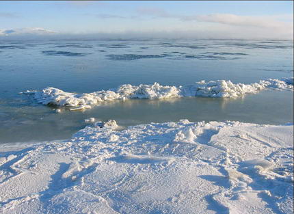
The Bering Sea is now one of the most developed in the world, despite the harsh climatic conditions. The surface water temperature in summer is +7-8°, in winter +2°. Water salinity is from 28-33‰. Tides in the Bering Sea are diurnal and semidiurnal. The average height of water level fluctuation is 1.5-2 m, in the Bering Strait it is only about 0.5 m, and in Bristol Bay it is sometimes 8 meters or more, the tidal speed is 1-2 m/s. In the sea area, cyclones with winds of up to 20-30 m/s are quite frequent, which cause strong and prolonged storms, wave heights can be up to 14 m. For a long time of the year, most of the Bering Sea is covered with ice.

The Bering Sea has long been considered one of the most commercial seas. There are more than 400 species of underwater inhabitants alone. About 35 species are commercially available, mainly salmon, cod and flounder. Red caviar, obtained from salmon fish, has been the most expensive delicacy for many years, which was and is being exported from here in tons, destroying millions of valuable species of fish. Some order is being established in this regard, but poaching still flourishes.

Crab fishing occupies a special place. Crab meat was once a food product only for Asians: Chinese, Japanese, etc. Over time, it gained popularity in many countries of the world. The Bering Sea is the place where the largest population of Kamchatka crab is located, and during the crab fishing season, thousands of ships from many countries sail to the Bering Sea. Although the crab fishing season is only a few days, during this time more than 30 thousand tons of crab are caught from the waters. Moreover, foreigners constantly violate the allocated quotas. But for many it is the main income and often a family business.

The fauna of the Bering Sea is very diverse. The waters are home to a huge number of walruses, sea lions, seals, and fur seals. They can often be seen in the open sea on ice floes.

On the Aleutian and Commander Islands, on the coast of Alaska and Chukotka, these marine animals establish numerous rookeries where they breed their offspring.

Quite a lot of whales live in the waters of the Bering Sea. Once there were more of them here than anywhere else on the globe, but for many years they were actively hunted. Special whaling fleets were created here, including the Russian “Slava” and “Aleut”, which killed hundreds of whales and their population fell sharply. In recent years, the number of whales has been gradually increasing.

It is not uncommon to see polar bears swimming on the open sea. Sometimes they stay for a long time on the shores, where there is more food than in the neighboring Chukchi Sea.

The fauna of the Berengov Sea coast is very rich and diverse. The forests are home to a large number of different animals: bears, moose, wolves, foxes, sable, marten, squirrel, arctic fox, ermine, etc. On the Chukotka Peninsula, numerous herds of reindeer have become one of the main wealth of this region.

Created several years ago, the Beringia National Park, located between Chukotka and Kamchatka, thanks to its protected status, has now become so populated with rare animals that it is becoming one of the most popular tourist destinations.

The number and diversity of birds in the Bering Sea is simply incredible. They set up huge bird colonies on rocky shores, where they raise their chicks. The bird population density on some islands exceeds 200,000 birds per 1 sq. km.

This sea is the easternmost border of our country and therefore it is reliably guarded. Border ships serve around the clock on the eastern sea border of our homeland.

Climatic conditions in the Berengov Sea region: Kamchatka, the Kuril Islands and the Chukotka Peninsula are quite harsh. The temperature is below zero for almost 9 months of the year. Severe snowy winters and cold winds are common here. And still, rarely do any of the people living on the coast of this very eastern sea agree to move to the mainland.
Page 3
The flora and fauna of the Bering Sea is quite rich and is represented by various species, from microscopic inhabitants to huge mammals.
Phytoplankton is dominated by diatoms. They float freely in the illuminated layer and are carried by currents.
In zooplankton, the main place is occupied by cold-loving forms of copepods. Their largest accumulations are observed at some distance from the coast, from where the biomass of zooplankton decreases both towards the coast and towards the central regions of the sea.
Bottom vegetation - phytobenthos - is widespread in the coastal zone, mainly in the southern part of the sea. Green, brown and red algae grow in shallow water, kelp (seaweed) and sea grass zoster are common. In places, accumulations of plants form extensive underwater meadows.
Among the bottom animals (zoobenthos) sponges, crustaceans, echinoderms, and mollusks predominate. These include several types of edible mussels, crabs and octopuses. Representatives of zoobenthos live not only in coastal waters, but also at great depths in the central regions of the sea.
The ichthyofauna includes about 315 species of fish, of which 25 species are of commercial importance. The most important of them include herring, salmon (chum salmon, pink salmon, chinook salmon, sockeye salmon), smelt, cod, pollock, navaga, halibut, and flounder.
Marine mammals live in the sea: whales, seals, including sea lions, walruses, fur seals, etc. However, their numbers are relatively small, so the production of whales and sea animals is limited and is carried out for the needs of the local population.
The Bering Sea washes the shores of the Chukotka Autonomous Okrug, the Kamchatka region of Russia and the US state of Alaska. Due to the great remoteness of these territories, their economic potential, especially coastal areas, is relatively small. However, economic activity is noticeably developed both in coastal areas and on the sea itself. In the Russian regions adjacent to the sea there are enterprises in the mining, fishing, engineering industries and energy systems. Main industrial centers: Anadyr, Provideniya. Various local crafts are common in Alaska. Main centers: the port of Nome and Dutch Harbor (Unalaska Island).
Maritime transport occupies an important place in the maritime economy. Shipping routes to many Russian and foreign ports pass through the Bering Sea. In the western part of the sea there is a route connecting the ports of the Far East with the Northern Sea Route.
The structure of transported cargo is dominated by petroleum products, timber, equipment for the mining industry, fish and fish products, food and cargo to supply the population of the northern regions.
Industrial activities at sea and in its coastal zone have a certain negative impact on the ecological state of the marine environment and the animals and plants inhabiting it, which is manifested mainly in sea pollution. The main sources of pollution are industrial and domestic wastewater. In addition, experts believe that a significant amount of pollutants enters the sea through long-distance atmospheric transport of toxic substances.
According to available data, 4.5 million m3 of wastewater was discharged into the Bering Sea in 1996, of which 2.8 million m3 required treatment. Sewage brought nitrates and synthetic surfactants into the sea; Data for 1996 are not available for other pollutants.
However, in previous years, there was a significant influx of various pollutants (petroleum products, suspended solids, synthetic surfactants, etc.) into the Anadyr Bay, Ugolnaya and Emma bays. In open areas, oil films were observed on the sea surface. Experts consider sea water to be relatively clean in the open part and slightly polluted in the port areas.
According to experts, the production of fish, whales and sea animals is generally close to normal. However, there is also overfishing, especially of valuable species (salmon, flounder), as well as violation of quotas for the production of whales and sea animals, which is fraught with a reduction in their numbers.
Overall, the Bering Sea ecosystem is likely to be in relatively good condition. However, its components contain dangerous toxic substances, mainly of anthropogenic origin. In the North, ecosystems are quite fragile, and further pollution can lead to their degradation and even destruction. Consequently, maintaining the ecological safety of the sea is a task that must be solved today.
Sanatorium-resort complex
The main directions of development of the resort city of Gelendzhik are sanatorium-resort and tourist-recreational. They have a stimulating effect on the development of other sectors of the economy. The resort has more than 140 sanatoriums and boarding houses, recreation centers and campsites, as well as private mini...
Imperial Porcelain Factory
The Imperial Porcelain Factory is a unique phenomenon. Its products, artistic porcelain, are the first porcelain in Russia, both in terms of the time of its origin and its significant contribution to Russian and world culture. The products of the plant, with their best examples of decorative and applied art, have won...
National cuisine
The food is dominated by dates, barley and wheat cakes, rice, sour milk, and vegetables. Dates are eaten with flatbreads and tea, they are used to make paste, sugar, halva, sweet drinks, and vodka. Steep porridge (burgul) is made from rice, which is usually eaten with sour milk (la-(ban). In some places, fish dishes are popular, but...
The Bering Sea is located in the North Pacific Ocean. It is separated from it by the Commander and Aleutian Islands and borders the Chukchi Sea through the Bering Strait. Through the Chukchi Sea you can go from the Bering Sea to the Arctic Ocean. In addition, this sea washes the coasts of two countries: the Russian Federation and the United States of America.
Physiographic location of the Bering Sea
The coastline of the sea is heavily indented with capes and bays. The largest bays located on the Russian coast are the Anadyrsky, Karaginsky, Olyutorsky, Korfa, and Kresta bays. And on the coast of North America there are Norton, Bristol, and Kuskokwim bays.
Only two large rivers flow into the sea: Anadyr and Yukon.
The Bering Sea also has many islands. They are mainly located on the border of the sea. The Russian Federation includes the Diomede Islands (the western one is Ratmanov Island). Commander Islands, Karaginsky Island. To the territory of the United States of America - the Pribilof Islands, the Aleutian Islands, the Diomede Islands (the eastern one is Krusenstern Island), St. Lawrence Island, Nunivak, King Island, St. Matthews Island.
In summer, the air temperature over the sea waters ranges from plus 7 to plus 10 degrees Celsius. In winter it drops to minus 23 degrees. The salinity of the water varies on average from 33 to 34.7 percent.
Seabed topography
The topography of the seabed in the northeastern part is marked by the continental shelf. Its length is more than 700 kilometers. The sea is quite shallow.
The southwestern section is deep-water and has depths of up to 4 kilometers. These two zones can be divided conditionally along an isobath of 200 meters.
The transition point between the continental shelf and the ocean floor is marked by a significantly steep continental slope. The Bering Sea has its maximum depth in the southern part - 4151 meters. The bottom of the shelf is covered with a mixture of sand, shell rock and gravel. In deep-sea areas, the bottom is covered with diatomaceous silt.
Temperature and salinity
 The layer at the surface of the sea, approximately 50 meters deep, throughout the entire water area warms up to 10 degrees Celsius in the summer months. In winter, the average minimum temperature is approximately minus 3 degrees. Salinity up to 50 meters in depth reaches 32 ppm.
Below 50 and up to 200 meters there is an intermediate water layer. The water here is colder, practically unchanged in temperature all year round (-1.7 degrees Celsius). Salinity reaches 34 percent.
Below 200 meters the water becomes warmer. Its temperature ranges from 2.5 to 4 degrees, and the salinity level is approximately 34 percent.
Ichthyofauna of the Bering Sea
The Bering Sea is home to approximately 402 different species of fish. Among these 402 species, you can find 9 species of sea goby, 7 species of salmon fish and many others. About 50 species of fish are commercially caught. Crabs, shrimp and cephalopods are also caught in the sea waters.
Among the mammals living in the Bering Sea are ringed seals, seals, bearded seals, lionfish and walruses. The list of cetaceans is also extensive. Among them you can find the gray whale, narwhal, bowhead whale, Japanese (or southern) whale, fin whale, humpback whale, sei whale, and northern blue whale. There are many rookeries for walruses and seals on the Chukotka Peninsula.
Geographical encyclopedia
Bering Sea- so called cap. Golovin in honor of the Russian captain commander V. Bering. B. sea, limited to the south. about you Aleutian and Commander, to the village. gradually narrows and ends with the Bering Strait. Extreme line of the Greater Sea: lat. 52° and 66° 30′… … Military encyclopedia
The BERING SEA, a semi-enclosed sea in the north Pacific Ocean, is separated from it by the Aleutian and Commander Seas. 2315 thousand km2. Greatest depth 5500 m, in the north less than 200 m. Large bays: Anadyrsky and Olyutorsky (off the coast of Russia), Norton, ... ... Russian history
A semi-enclosed sea in the north of the Pacific Ocean, separated from it by the Aleutian and Commander Islands. 2315 thousand km². The greatest depth is 5500 m, in the north less than 200 m. Large bays: Anadyrsky and Olyutorsky (off the coast of the Russian Federation), Norton, ... ... Big Encyclopedic Dictionary
Modern encyclopedia
Bering Sea- The Pacific Ocean, between Eurasia and North America, limited to the south by the Aleutian and Commander Islands. It is connected to the Chukchi Sea by the Bering Strait. Area 2315 thousand km2. Depth up to 5500 m. Large islands: St. Lawrence, Nunivak.... ... Illustrated Encyclopedic Dictionary
- (named after the navigator V. Bering, the semi-enclosed sea of the Pacific Ocean between the continents of Asia in the west (USSR), North America in the east (USA) and the Commander (USSR) and Aleutian (USA) islands in the south. In the north it is closed by the Chukotka peninsulas And… … Great Soviet Encyclopedia
A semi-enclosed sea in the north Pacific Ocean, separated from it by the Aleutian and Commander Islands. 2315 thousand km2. The greatest depth is 5500 m, in the north less than 200 m. Large bays: Anadyrsky and Olyutorsky (off the coast of Russia), Norton, Bristol ... Encyclopedic Dictionary
Bering Sea- The Pacific Ocean, between Asia (Russia: Chukotka and Koryak Autonomous Okrug, Kamchatka region) and the North. America (USA, Alaska). Named in honor of captain commander V.I. Bering (1681 1741), under whose command the participants of the First and Second Kamchatka expeditions to... ... Toponymic dictionary
Or the Kamchatka Sea is the northeastern part of the Pacific Ocean, bounded from the west by North America, and from the east by Asia and connected to the Arctic Ocean through the Bering Strait. The narrowest part of this strait is the gap... ... Encyclopedic Dictionary F.A. Brockhaus and I.A. Efron
Books
- Bering Sea. Encyclopedia. Zonn I. S., Kostyanoy A. G., Kumantsov M. I., Zonn Igor Sergeevich, Kostyanoy Andrey Gennadievich, Kumantsov Mikhail Ivanovich. The publication is dedicated to one of the Russian Far Eastern seas - the Bering Sea, which is part of the Pacific Ocean. The encyclopedia contains more than 700 articles on hydrographic and geographical...
- Bering Sea. Encyclopedia, Zonn Igor Sergeevich, Kostyanoy Andrey Gennadievich, Kumantsov Mikhail Ivanovich. The publication is dedicated to one of the Russian Far Eastern seas - the Bering Sea, which is part of the Pacific Ocean. The encyclopedia contains more than 700 articles on hydrographic and geographical...