What parts do lithospheric plates consist of? Origin of continents and oceans
Read more in the article History of the theory of plate tectonicsThe basis of theoretical geology at the beginning of the 20th century was the contraction hypothesis. The earth cools like a baked apple, and wrinkles appear on it in the form of mountain ranges. These ideas were developed by the theory of geosynclines, created on the basis of the study of folded structures. This theory was formulated by J. Dan, who added the principle of isostasy to the contraction hypothesis. According to this concept, the Earth consists of granites (continents) and basalts (oceans). When the Earth contracts, tangential forces arise in the ocean basins, which press on the continents. The latter rise into mountain ranges and then collapse. The material that results from destruction is deposited in the depressions.
The sluggish struggle between the fixists, as supporters of the absence of significant horizontal movements were called, and the mobilists, who argued that they were still moving, flared up with renewed vigor in the 1960s, when, as a result of studying the bottom of the oceans, clues were found to understand the “machine” called the Earth .
By the early 60s, a relief map of the ocean floor was compiled, which showed that mid-ocean ridges are located in the center of the oceans, which rise 1.5–2 km above the abyssal plains covered with sediment. These data allowed R. Dietz and G. Hess to put forward the spreading hypothesis in 1962–1963. According to this hypothesis, convection occurs in the mantle at a speed of about 1 cm/year. The ascending branches of convection cells carry out mantle material under mid-ocean ridges, which renews the ocean floor in the axial part of the ridge every 300–400 years. Continents do not float on the oceanic crust, but move along the mantle, being passively “soldered” into lithospheric plates. According to the concept of spreading, ocean basins have a variable and unstable structure, while continents are stable.
In 1963, the spreading hypothesis received strong support in connection with the discovery of striped magnetic anomalies on the ocean floor. They have been interpreted as a record of reversals of the Earth's magnetic field, recorded in the magnetization of basalts of the ocean floor. After this, plate tectonics began its triumphant march in the earth sciences. More and more scientists realized that, rather than waste time defending the concept of fixism, it was better to look at the planet from the point of view of a new theory and, finally, begin to give real explanations for the most complex earthly processes.
Plate tectonics has now been confirmed by direct measurements of plate velocity using interferometry of radiation from distant quasars and measurements using GPS. The results of many years of research have fully confirmed the basic principles of the theory of plate tectonics.
Current state of plate tectonics
Over the past decades, plate tectonics has significantly changed its basic principles. Nowadays they can be formulated as follows:
- Top part solid earth divided into brittle lithosphere and ductile asthenosphere. Convection in the asthenosphere is the main cause of plate movement.
- The lithosphere is divided into 8 large plates, dozens of medium plates and many small ones. Small slabs are located in the belts between large slabs. Seismic, tectonic, and magmatic activity is concentrated at plate boundaries.
- Lithospheric plates to a first approximation, they are described as rigid bodies, and their motion obeys Euler's rotation theorem.
- There are three main types of relative plate movements
- divergence (divergence), expressed by rifting and spreading;
- convergence (convergence) expressed by subduction and collision;
- strike-slip movements along transform faults.
- Spreading in the oceans is compensated by subduction and collision along their periphery, and the radius and volume of the Earth are constant (this statement is constantly discussed, but it has never been refuted)
- The movement of lithospheric plates is caused by their entrainment by convective currents in the asthenosphere.
There are two fundamentally different types Earth's crust - continental crust and oceanic crust. Some lithospheric plates are composed exclusively of oceanic crust (an example is the largest Pacific plate), others consist of a block of continental crust welded into the oceanic crust.
More than 90% of the Earth's surface is covered by 8 largest lithospheric plates:
Medium-sized plates include the Arabian subcontinent and the Cocos and Juan de Fuca plates, remnants of the enormous Faralon plate that formed much of the Pacific Ocean floor but has now disappeared into the subduction zone beneath the Americas.
The force that moves the plates
Now there is no longer any doubt that the movement of plates occurs due to mantle thermogravitational currents - convection. The energy source for these currents is the transfer of heat from the central parts of the Earth, which have a very high temperature (estimated core temperature is about 5000 ° C). Heated rocks expand (see thermal expansion), their density decreases, and they float up, giving way to cooler rocks. These currents can close and form stable convective cells. In this case, in the upper part of the cell, the flow of matter occurs in a horizontal plane and it is this part of it that transports the plates.
Thus, the movement of plates is a consequence of the cooling of the Earth, during which part of the thermal energy is converted into mechanical work, and our planet, in a sense, is a heat engine.
There are several hypotheses regarding the cause of the high temperature of the Earth's interior. At the beginning of the 20th century, the hypothesis of the radioactive nature of this energy was popular. It seemed to be confirmed by the composition estimates upper crust, which showed very significant concentrations of uranium, potassium and other radioactive elements, but later it turned out that with depth the content of radioactive elements drops sharply. Another model explains the heating by chemical differentiation of the Earth. The planet was originally a mixture of silicate and metallic substances. But simultaneously with the formation of the planet, its differentiation into separate shells began. The denser metal part rushed to the center of the planet, and silicates concentrated in the upper shells. At the same time, the potential energy of the system decreased and was converted into thermal energy. Other researchers believe that the heating of the planet occurred as a result of accretion during meteorite impacts on the surface of the nascent celestial body.
Secondary forces
Thermal convection plays a decisive role in the movements of plates, but in addition to it, smaller but no less important forces act on the plates.
As oceanic crust sinks into the mantle, the basalts of which it is composed transform into eclogites, rocks denser than ordinary mantle rocks - peridotites. Therefore, this part of the oceanic plate sinks into the mantle, and pulls with it the part that has not yet been eclogitized.
Divergent boundaries or plate boundaries
These are boundaries between plates moving in opposite directions. In the Earth's topography, these boundaries are expressed as rifts, where tensile deformations predominate, the thickness of the crust is reduced, the heat flow is maximum, and active volcanism occurs. If such a boundary forms on a continent, then a continental rift is formed, which can later turn into an oceanic basin with an oceanic rift in the center. In oceanic rifts, new oceanic crust is formed as a result of spreading.
Ocean rifts
On the oceanic crust, rifts are confined to the central parts of mid-ocean ridges. New oceanic crust is formed in them. Their total length is more than 60 thousand kilometers. They are associated with many, which carry a significant part of the deep heat and dissolved elements into the ocean. High-temperature sources are called black smokers, and significant reserves of non-ferrous metals are associated with them.
Continental rifts
The breakup of the continent into parts begins with the formation of a rift. The crust thins and moves apart, and magmatism begins. An extended linear depression with a depth of about hundreds of meters is formed, which is limited by a series of faults. After this, two scenarios are possible: either the expansion of the rift stops and it is filled with sedimentary rocks, turning into an aulacogen, or the continents continue to move apart and between them, already in typical oceanic rifts, oceanic crust begins to form.
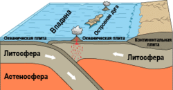
Convergent boundaries
Read more in the article Subduction ZoneConvergent boundaries are boundaries where plates collide. Three options are possible:
- Continental plate with oceanic plate. Oceanic crust is denser than continental crust and sinks beneath the continent at a subduction zone.
- Oceanic plate with oceanic plate. In this case, one of the plates creeps under the other and a subduction zone is also formed, above which an island arc is formed.
- Continental plate with continental one. A collision occurs and a powerful folded area appears. A classic example is the Himalayas.
In rare cases, oceanic crust is pushed onto continental crust - obduction. Thanks to this process, ophiolites of Cyprus, New Caledonia, Oman and others arose.
In subduction zones, oceanic crust is absorbed, thereby compensating for its appearance in the MOR. Extremely complex processes and interactions between the crust and mantle take place in them. Thus, the oceanic crust can pull blocks of continental crust into the mantle, which, due to their low density, are exhumed back into the crust. This is how metamorphic complexes of ultra-high pressures arise, one of the most popular objects of modern geological research.
Most modern subduction zones are located along the periphery of the Pacific Ocean, forming the Pacific Ring of Fire. The processes occurring in the plate convection zone are rightfully considered to be among the most complex in geology. It mixes blocks of different origins, forming a new continental crust.
Active continental margins
Read more in the article Active continental marginAn active continental margin occurs where oceanic crust subducts beneath a continent. The standard of this geodynamic situation is considered West Coast South America, it is often called Andean type of continental margin. The active continental margin is characterized by numerous volcanoes and generally powerful magmatism. Melts have three components: the oceanic crust, the mantle above it, and the lower continental crust.
Beneath the active continental margin, there is active mechanical interaction between the oceanic and continental plates. Depending on the speed, age and thickness of the oceanic crust, several equilibrium scenarios are possible. If the plate moves slowly and has a relatively low thickness, then the continent scrapes off the sedimentary cover from it. Sedimentary rocks are crushed into intense folds, metamorphosed and become part of the continental crust. The structure that forms is called accretionary wedge. If the speed of the subducting plate is high and the sedimentary cover is thin, then the oceanic crust erases the bottom of the continent and draws it into the mantle.
Island arcs
Island arc
Read more in the article Island ArcIsland arcs are chains of volcanic islands above a subduction zone, occurring where an oceanic plate subducts beneath an oceanic plate. Typical modern island arcs include the Aleutian, Kuril, Mariana Islands, and many other archipelagos. The Japanese Islands are also often called an island arc, but their foundation is very ancient and in fact they were formed by several island arc complexes at different times, so the Japanese Islands are a microcontinent.
Island arcs are formed when two oceanic plates collide. In this case, one of the plates ends up at the bottom and is absorbed into the mantle. Island arc volcanoes form on the upper plate. The curved side of the island arc is directed towards the absorbed plate. On this side there is a deep-sea trench and a forearc trough.
Behind the island arc there is a back-arc basin (typical examples: Sea of Okhotsk, South China Sea, etc.) in which spreading can also occur.
Continental collision
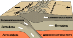
Collision of continents
Read more in the article Continental CollisionThe collision of continental plates leads to the collapse of the crust and the formation of mountain ranges. An example of a collision is the Alpine-Himalayan mountain belt, formed as a result of the closure of the Tethys Ocean and the collision with the Eurasian Plate of Hindustan and Africa. As a result, the thickness of the crust increases significantly; under the Himalayas it reaches 70 km. This is an unstable structure; it is intensively destroyed by surface and tectonic erosion. In the crust with a sharply increased thickness, granites are smelted from metamorphosed sedimentary and igneous rocks. This is how the largest batholiths were formed, for example, Angara-Vitimsky and Zerendinsky.
Transform boundaries
Where plates move in parallel courses, but at different speeds, transform faults arise - enormous shear faults, widespread in the oceans and rare on continents.
Transform faults
More details in the article Transform faultIn the oceans, transform faults run perpendicular to mid-ocean ridges (MORs) and break them into segments averaging 400 km wide. Between the ridge segments there is an active part of the transform fault. Earthquakes and mountain building constantly occur in this area; numerous feathering structures are formed around the fault - thrusts, folds and grabens. As a result, mantle rocks are often exposed in the fault zone.
On both sides of the MOR segments there are inactive parts of transform faults. There are no active movements in them, but they are clearly expressed in the topography of the ocean floor by linear uplifts with a central depression. .
Transform faults form a regular network and, obviously, do not arise by chance, but due to objective physical reasons. A combination of numerical modeling data, thermophysical experiments and geophysical observations made it possible to find out that mantle convection has a three-dimensional structure. In addition to the main flow from the MOR, longitudinal currents arise in the convective cell due to the cooling of the upper part of the flow. This cooled substance rushes down along the main direction of the mantle flow. Transform faults are located in the zones of this secondary descending flow. This model agrees well with the data on heat flow: a decrease in heat flow is observed above transform faults.
Continental shifts
More details in the article ShiftStrike-slip plate boundaries on continents are relatively rare. Perhaps the only currently active example of a boundary of this type is the San Andreas Fault, which separates the North American Plate from the Pacific Plate. The 800-mile San Andreas Fault is one of the most seismically active areas on the planet: plates move relative to each other by 0.6 cm per year, earthquakes with a magnitude of more than 6 units occur on average once every 22 years. The city of San Francisco and much of the San Francisco Bay area are built in close proximity from this fault.
Within-plate processes
The first formulations of plate tectonics argued that volcanism and seismic phenomena are concentrated along plate boundaries, but it soon became clear that specific tectonic and magmatic processes, which were also interpreted within the framework of this theory. Among intraplate processes, a special place was occupied by the phenomena of long-term basaltic magmatism in some areas, the so-called hot spots.
Hot Spots
There are numerous volcanic islands at the bottom of the oceans. Some of them are located in chains with successively changing ages. A classic example of such an underwater ridge is the Hawaiian Underwater Ridge. It rises above the surface of the ocean in the form of the Hawaiian Islands, from which a chain of seamounts with continuously increasing age extends to the northwest, some of which, for example, Midway Atoll, come to the surface. At a distance of about 3000 km from Hawaii, the chain turns slightly to the north, and is already called the Imperial Ridge. It is interrupted in a deep-sea trench in front of the Aleutian island arc.
To explain this amazing structure, it was suggested that under Hawaiian Islands there is a hot spot - a place where a hot mantle flow rises to the surface, which melts the oceanic crust moving above it. There are many such points now installed on Earth. The mantle flow that causes them has been called a plume. In some cases, an exceptionally deep origin of the plume matter is assumed, down to the core-mantle boundary.
Traps and oceanic plateaus
In addition to long-term hot spots, enormous outpourings of melts sometimes occur inside plates, which form traps on continents and oceanic plateaus in oceans. The peculiarity of this type of magmatism is that it occurs in a short geological time of the order of several million years, but it covers huge areas (tens of thousands of km²) and a colossal volume of basalts is poured out, comparable to their amount crystallizing in mid-ocean ridges.
The Siberian traps on the East Siberian Platform, the Deccan Plateau traps on the Hindustan continent and many others are known. Hot mantle flows are also considered to be the cause of the formation of traps, but unlike hot spots, they act for a short time, and the difference between them is not entirely clear.
Hot spots and traps gave rise to the creation of the so-called plume geotectonics, which states that not only regular convection, but also plumes play a significant role in geodynamic processes. Plume tectonics does not contradict plate tectonics, but complements it.
Plate tectonics as a system of sciences
![]()
Tectonic plate map
Now tectonics can no longer be considered as a purely geological concept. It plays a key role in all geosciences; several methodological approaches with different basic concepts and principles have emerged in it.
From point of view kinematic approach, the movements of the plates can be described by the geometric laws of movement of figures on a sphere. The Earth is seen as a mosaic of plates of different sizes moving relative to each other and the planet itself. Paleomagnetic data allows us to reconstruct the position of the magnetic pole relative to each plate at different points in time. Generalization of data for different plates led to the reconstruction of the entire sequence of relative movements of the plates. Combining this data with information obtained from fixed hot spots made it possible to determine the absolute movements of the plates and the history of the movement of the Earth's magnetic poles.
Thermophysical approach considers the Earth as a heat engine, in which thermal energy is partially converted into mechanical energy. Within this approach, the movement of matter in the inner layers of the Earth is modeled as a flow of a viscous fluid, described by the Navier-Stokes equations. Mantle convection is accompanied by phase transitions and chemical reactions, which play a decisive role in the structure of mantle flows. Based on geophysical sounding data, the results of thermophysical experiments and analytical and numerical calculations, scientists are trying to detail the structure of mantle convection, find flow velocities and other important characteristics of deep processes. These data are especially important for understanding the structure of the deepest parts of the Earth - the lower mantle and core, which are inaccessible for direct study, but undoubtedly have a huge impact on the processes occurring on the surface of the planet.
Geochemical approach. For geochemistry, plate tectonics is important as a mechanism for the continuous exchange of matter and energy between the different layers of the Earth. Each geodynamic setting is characterized by specific rock associations. In turn, these characteristic features can be used to determine the geodynamic environment in which the rock was formed.
Historical approach. In terms of the history of planet Earth, plate tectonics is the history of continents joining and breaking apart, the birth and decay of volcanic chains, and the appearance and closure of oceans and seas. Now for large blocks of the crust the history of movements has been established in great detail and over a significant period of time, but for small plates the methodological difficulties are much greater. The most complex geodynamic processes occur in plate collision zones, where mountain ranges are formed, composed of many small heterogeneous blocks - terranes, carried out in 1999 by the Proterozoic space station. Before this, the mantle may have had a different mass transfer structure, in which turbulent convection and plumes played a major role rather than steady convective flows.
Past plate movements
Read more in the article History of plate movementReconstructing past plate movements is one of the main subjects of geological research. With varying degrees of detail, the position of the continents and the blocks from which they were formed has been reconstructed up to the Archean.
Moves north and crushes Eurasian plate, but, apparently, the resource of this movement is almost exhausted, and in the near geological time a new subduction zone will arise in the Indian Ocean, in which the oceanic crust Indian Ocean will be absorbed under the Indian continent.
The influence of plate movements on climate
The location of large continental masses in the subpolar regions contributes to a general decrease in the temperature of the planet, since ice sheets can form on the continents. The more widespread glaciation is, the greater the planet's albedo and the lower the average annual temperature.
In addition, the relative position of the continents determines oceanic and atmospheric circulation.
However, a simple and logical scheme: continents in the polar regions - glaciation, continents in the equatorial regions - increase in temperature, turns out to be incorrect when compared with geological data about the Earth's past. Quaternary glaciation actually occurred when Antarctica appeared in the region of the South Pole, and in the northern hemisphere Eurasia and North America approached the North Pole. On the other hand, the strongest Proterozoic glaciation, during which the Earth was almost completely covered with ice, occurred when most of the continental masses were in the equatorial region.
In addition, significant changes in the position of the continents occur over a period of about tens of millions of years, while the total duration of ice ages is about several million years, and during one ice age cyclical changes of glaciations and interglacial periods occur. All of these climate changes occur quickly compared to the speed of continental movement, and therefore plate movement cannot be the cause.
From the above it follows that plate movements do not play a decisive role in climate change, but can be an important additional factor “pushing” them.
The meaning of plate tectonics
Plate tectonics has played a role in the earth sciences comparable to the heliocentric concept in astronomy or the discovery of DNA in genetics. Before the adoption of the theory of plate tectonics, earth sciences were descriptive in nature. They achieved a high level of perfection in describing natural objects, but rarely could explain the causes of processes. Opposite concepts could dominate in different branches of geology. Plate tectonics connected the various earth sciences and gave them predictive power.
V. E. Khain. over regions and smaller smaller time scales.
Perhaps some readers have heard discussions on the topic of identifying planet Earth with some living superorganism. In particular, it is usually argued that the Earth is capable of itself controlling the processes occurring on it and with it, in addition to being responsible for the existence of life. This is about Gaia theory. Gaia, in turn, was the ancient Greek goddess of the Earth. By and large, it does not matter at all whether life on the planet will be a consequence of the “conscious” activity of the planet itself as an organism, a confluence of a number of “random” circumstances, or a consequence of the existence of a universal law on zones favorable for life.
One way or another, life on the planet exists, and it is likely that in order for it to arise, many coincidences or assumptions of different nature were necessary. One of which, of course, is the geology of the planet.
Tectonic or lithospheric plates are responsible for geological activity on Earth.
Lithospheric plates of our planet
For a more visual representation, you can look at the 3D model:
It is believed that the movement of plates can influence the existence of life on the planet. Thus, geological activity is characteristic not only of the Earth, but also celestial bodies Solar system. However, the Earth is unique not in the presence of earthquakes, which exist even on Mars (which are called moonquakes and marsquakes, respectively), but rather in the presence of developed and strong tectonic activity.
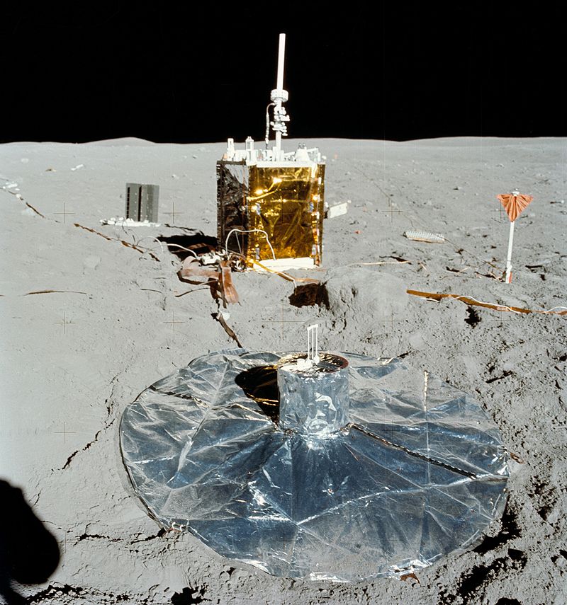
Seismometer on the Moon
Also, Earth is the only planet in solar system, the outer crust of which is broken into slabs. Tectonic plates reach tens of kilometers in thickness.
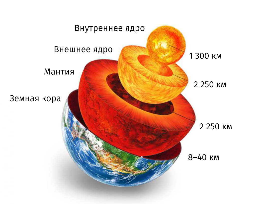
Thickness (thickness) of the Earth's layers
They tried to describe the reason for the movement of tectonic plates and continents by expanding the radius of the Earth. This is a very beautiful hypothesis, which hardly has anything in common with reality.
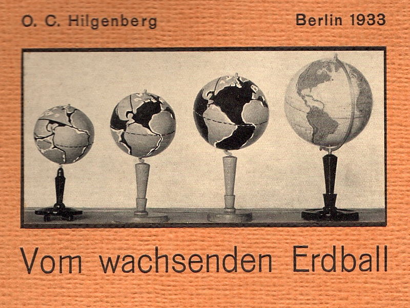
Models by Christoph Hilgenberg showing the expanding Earth
In fact, the main reason for the active movement of lithospheric plates is thermal convection. When heated, the lower layers become lighter and float, while the upper layers, away from the heat source, cool and, becoming heavier, sink down. Convection can be observed when the wind moves, when in some parts of the Earth the air heats up, and in others it cools at the point of contact and movement is created. And if we, in fact, cannot observe the wind and air currents (they can only be felt), then we can look at the phenomenon of convection in a lava lamp.
Of course, the oil in a lava lamp is not igneous rocks in the mantle, but we should not forget about such a factor as time. Namely, the fact that on the scale of seconds (in which an individual person essentially lives and thinks) the substance of the Earth’s mantle is solid, but on the scale of years and decades this substance acquires liquid properties. It may also depend on the size of the object in question.
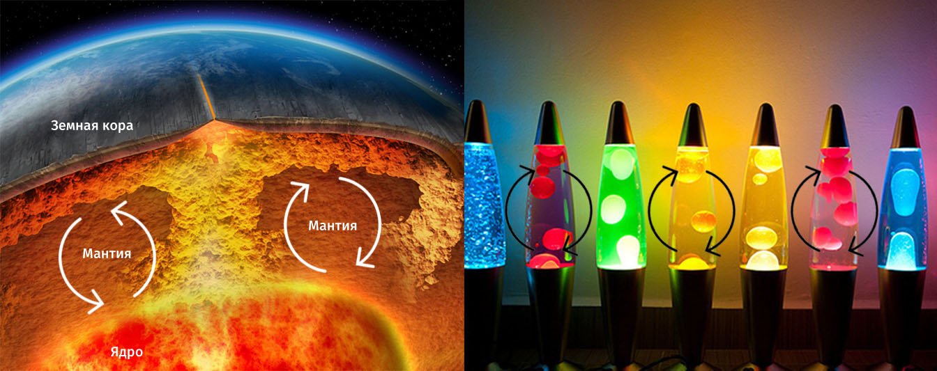
Comparison of convection in the Earth's mantle and in lava lamps
In part, this also suggests that life and the speed of perception of the surrounding space are preferable on the scale of seconds (or maximum minutes). Whereas global and cosmic processes must exist on a slower time scale. It turns out that in addition to the need for the existence of favorable zones for life, there is also a need for a certain time window of a certain scale. But we'll talk about this later.
It will be interesting to look at the phenomenon of convection in the mantle based on the results modern research Schmelling, which display cold (blue) and hot (red) regions in the Earth's mantle.
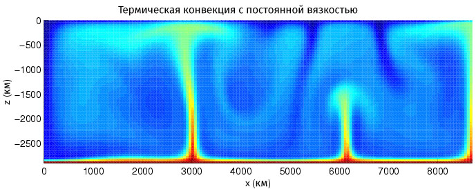
Convective movement in the Earth's mantle, color represents temperature. The z coordinate represents the depth to the mantle-core boundary (the Gutenberg discontinuity), and the x coordinate represents part of the circumference of the core (or the Gutenberg discontinuity).
This image clearly shows the convective movement within the mantle. The movement caused by convection leads to a number of processes, namely the movement of tectonic plates and its consequences.
The movement between two plates can obviously be either converging and colliding, or diverging and forming a fault. Convergence or convergence leads to subduction (one plate slides under another) or collision (the crushing of two plates to form mountain ranges). Segregation or divergence leads to spreading (the moving apart of plates to form ridges in the oceans) and rifting (the formation of a rift in the continental crust). There is also a third type of plate movement - transform, when plates move along a fault. One way or another, it is worth talking about the nature of plate movement separately, especially given the large amount of terminology.
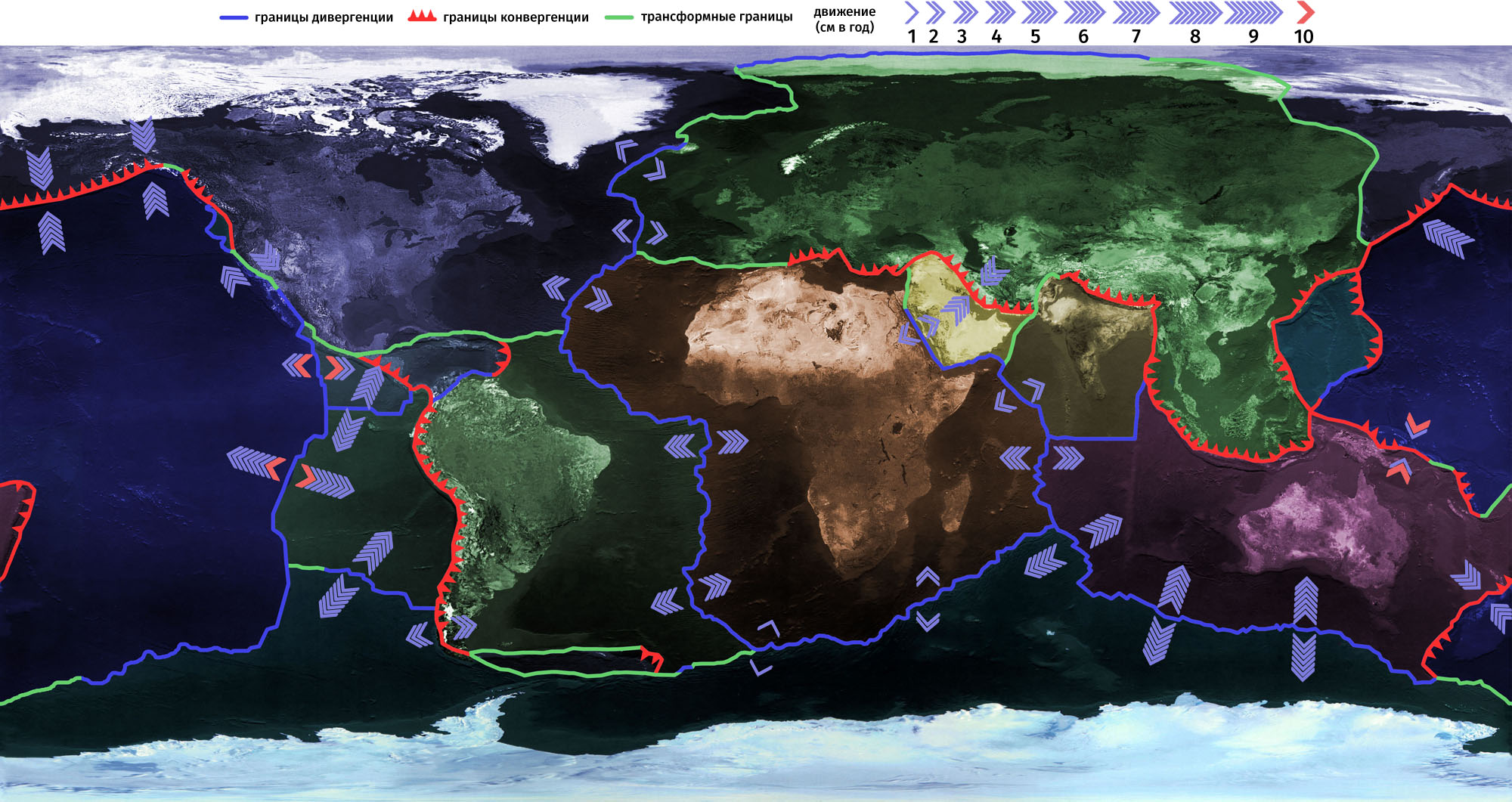
The speed of movement of the Earth's tectonic plates, and the types of movement of these plates at their boundaries.
It is also worth mentioning the thickness of the slabs, or their power. The earth's crust is continental and oceanic; oceanic Earth's crust reaches 5–15 km, while the continental crust reaches 15–80 km. This suggests that, compared to the mantle, the earth's crust is extremely thin. Therefore, the movement of plates and their stable state, even on a scale of seconds, is extremely difficult to imagine (if at all possible). And therefore, the movement of tectonic plates in itself can cause extreme surprise with its impossibility of structure, complexity of implementation and seeming unreliability. One way or another, we have not been given anything better.
The result of plate movement, in addition to existing life (although this has not been proven), can be called earthquakes and volcanism. If volcanoes are common not only at plate boundaries, then the map of earthquakes over the past decades clearly outlines the boundaries of tectonic plates, and the relationship here is apparently direct. The ring of volcanoes around the Pacific Plate is called the "Pacific Ring of Fire."

Map of recent earthquakes and active volcanoes
What will the movement of tectonic plates on Earth lead to in the future, and what will come of it, we will tell in subsequent materials.
The Earth's crust is divided by faults into lithospheric plates, which are huge solid blocks reaching upper layers mantle. They are large, stable parts of the earth's crust and are in continuous motion, sliding along the surface of the Earth. Lithospheric plates consist of either continental or oceanic crust, and some combine a continental massif with an oceanic one. There are 7 largest lithospheric plates, which occupy 90% of the surface of our planet: Antarctic, Eurasian, African, Pacific, Indo-Australian, South American, North American. In addition to them, there are dozens of medium-sized slabs and many small ones. Between the medium and large slabs there are belts in the form of mosaics of small slabs of bark.
Theory of plate tectonics
The theory of lithospheric plates studies their movement and the processes associated with this movement. This theory states that the cause of global tectonic changes is the horizontal movement of lithosphere blocks - plates. Plate tectonics examines the interaction and movement of blocks of the earth's crust. 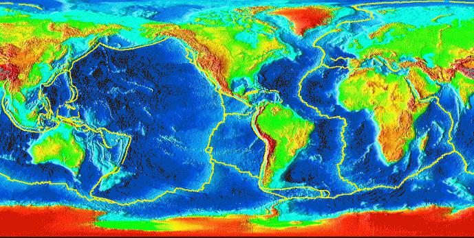
Wagner's theory
The idea that lithospheric plates move horizontally was first suggested in the 1920s by Alfred Wagner. He put forward a hypothesis about “continental drift”, but it was not recognized as reliable at that time. Later, in the 1960s, studies of the ocean floor were carried out, as a result of which Wagner’s guesses about the horizontal movement of plates were confirmed, and the presence of processes of ocean expansion, caused by the formation of oceanic crust (spreading), was revealed. The main provisions of the theory were formulated in 1967-68 by American geophysicists J. Isaacs, C. Le Pichon, L. Sykes, J. Oliver, W. J. Morgan. According to this theory, plate boundaries are located in zones of tectonic, seismic and volcanic activity. Boundaries are divergent, transformative and convergent. 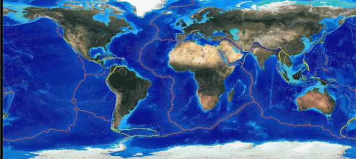
Movement of lithospheric plates
Lithospheric plates begin to move due to the movement of matter located in the upper mantle. In rift zones, this substance breaks through the crust, pushing plates apart. Most of rifts are located on the ocean floor, since the earth’s crust there is much thinner. The largest rifts that exist on land are located near Lake Baikal and the African Great Lakes. The movement of lithospheric plates occurs at a speed of 1-6 cm per year. When they collide with each other, mountain systems arise at their boundaries in the presence of continental crust, and in the case when one of the plates has a crust of oceanic origin, deep-sea trenches are formed.
The basic principles of plate tectonics come down to several points.
- In the upper rocky part of the Earth, there are two shells that differ significantly in geological characteristics. These shells are the hard and brittle lithosphere and the mobile asthenosphere underneath. The base of the lithosphere is a hot isotherm with a temperature of 1300°C.
- The lithosphere consists of plates of the earth's crust continuously moving along the surface of the asthenosphere.
Most people have at least a vague and most general idea that the earth’s surface is not at all monolithic, not “solid earth,” to use the old expression, but a system of plates interacting with each other. Most often in conversations at the everyday level, the phrase “tectonic plates” is used, which should reflect the moving nature of this system (tectonics is, among other things, the history of the movement of the plates that make up the earth’s surface). The Earth's surface is indeed made of plates, but there are no tectonic plates.
Lithospheric plates - yes, tectonic plates - no
300 million years ago, plate movement created a single terrestrial continent, Panagea, which was surrounded by a single ocean, Panthalassa. About 100 million years ago, Panagea began to break apart to form the modern continents
In fact, there was confusion with the concepts. There is a concept of lithosphere, that is, the solid shell of the earth. There is a concept of lithospheric plates - the largest and most stable sections of the lithosphere, earth's surface. And there is the concept of “plate tectonics,” which means modern scientific discipline, which studies the movement of lithospheric plates relative to each other.
According to the theory based on plate tectonics data, new crust, the solid shell of the Earth, appears in expansion zones on the ocean floor, and old crust is absorbed in subduction zones. The philistine consciousness mixed the idea of lithospheric plates and the scientific theory of their constant movement (plate tectonics): as a result, “tectonic plates” appeared, which are more correctly called “moving lithospheric plates.”
Currently, plate tectonics presents the following picture. The modern lithosphere is divided into many lithospheric plates, but 90% of the earth's surface is divided into eight main plates. The earth's surface is of two types: oceanic crust (younger, as it is constantly renewed) and continental crust (more ancient).
The plates on which the continents stand continue to move to this day - several centimeters per year
Lithospheric plates can carry out Various types movements relative to each other, there are three main types of movement: first, divergence, that is, the discrepancy between the plates; secondly, convergence, that is, convergence, rapprochement between plates; thirdly, shear movements along transform geological faults. Scientists currently believe that plate tectonics does not play a decisive role in global climate change.  , however, may have an auxiliary effect on these processes.
The plates on which humanity lives
The main, largest and most stable areas of the earth's surface are eight lithospheric plates:
- Indo-Australian plate - it contains Australia and the surrounding part of the ocean, reaching the Hindustan Peninsula. Currently, the movement of this lithospheric plate to the east from the north is noted at a speed of 67 millimeters per year;
- Antarctic plate - occupies southern part planet, it contains Antarctica and adjacent areas of the oceanic crust. This plate is relatively stable because it is surrounded by mid-ocean ridges, and other lithospheric plates are moving away from it;
- African plate - it contains the African continent, as well as a section of oceanic crust that occupies part of the floor of the Indian and Atlantic oceans. At the same time, in its northeastern part, this plate actually splits - the territory of the Arabian Peninsula already constitutes almost a separate plate. The lithospheric plates adjacent to the African plate are moving away from it, while in the northern part it itself is sinking into the mantle at a speed of 27 millimeters per year (the process of sinking plates into the mantle is subduction);
- Eurasian plate - the main territory of the Eurasian continent is located on it; this plate does not include the Hindustan Peninsula, the Arabian Peninsula and the northeastern “corner” of the continent. The largest lithospheric plate on Earth in terms of continental crust content;
- Indian plate - the Hindustan Peninsula is located on it, this medium-sized plate about 90 million years ago began to move from Madagascar to the north at a speed of 200 millimeters per year (such a high speed is due to the smaller thickness of the plate), and about 50 million years ago the process of its collision began with the Eurasian plate. As a result of the collision, the Tibetan Plateau and the Himalayas appeared. The Indian plate continues to move northeast at a speed of 50 millimeters per year, while the Eurasian plate “runs away” from it to the north at a speed of only 20 millimeters per year. In addition, the Indian plate has three subduction zones: in one it sinks into the mantle at a rate of 55 millimeters per year, in another at a rate of 67 millimeters per year, in the third at a speed of 87 millimeters per year;
- Pacific plate - it contains a section of oceanic crust that makes up the bottom Pacific Ocean. In the California region, the plate is moving north at a speed of 55 millimeters per year. At the same time, the size of the Pacific Plate is constantly decreasing due to the fact that it has several subduction zones at once: under the Eurasian Plate it is sinking into the mantle at a speed of 75 millimeters per year; under Indian - at a speed of 82 millimeters per year; under the North American - at a speed of 35 millimeters per year; under the medium-sized Philippine lithospheric plate - at a speed of 12 millimeters per year;
- North American plate - the North American continent is located on it, the northwestern part Atlantic Ocean, approximately half of the Arctic Ocean and the northeastern “corner” of Eurasia;
- South American plate - it contains South America and part of the floor of the Atlantic Ocean, formed about 70 million years ago as a result of the breakup of the ancient supercontinent Gondwana. It has a subduction zone in which the crust sinks into the mantle at a rate of 19 millimeters per year and 5 millimeters per year.
Alexander Babitsky