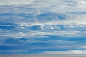
Clouds are stratified, cirrus and curly. What is a cloud
Without a doubt, a unique phenomenon that can be observed in the lower Earth is, of course, clouds. The various shapes and types of clouds simply cannot help but amaze. It would seem, how can these different clouds be classified? It turns out it is possible! And it's very simple. You yourself have probably noticed more than once that some clouds form very high in the sky, while others against their background are much lower. It turns out that different clouds form in the sky at different altitudes. Those types of clouds that are almost invisible, have a translucent color and the shape of the threads, moving along the Sun or Moon, practically do not weaken their light. And those that are lower have a denser structure and almost completely hide the Moon and the Sun.
How do clouds form? As we have already said, clouds are air, more precisely warm air, which rises from the earth's surface from a certain height, the air cools, and steam is converted into water. This is what clouds are made of.
But what determines the shape and types of clouds? And this depends on the height at which the cloud formed and the temperature that is there. Let's take a closer look at the different types of clouds.
Silvery - formed at an altitude of 70-90 km from the surface of the earth. They are a fairly thin layer that is barely noticeable against the sky at night.
Mother-of-pearl clouds are located at an altitude of 20-30 km. Such clouds form relatively rarely. They can be seen before the Sun rises, or when it sets below the horizon.
Cirrus - located at an altitude of 7-10 km. Thin clouds of white color that look like tangled or parallel threads.
Cirrostratus clouds are located at a distance of 6-8 km from the earth. They are a veil of white or blue color.
Cirrocumulus - also found at an altitude of 6-8 km. Thin clouds of white color that look like a cluster of flakes.
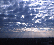
Altocumulus clouds - 2-6 km. A faintly translucent layer of clouds in the form of waves of white, gray or blue. Light precipitation may fall from this type of cloud.
Highly layered - 3-5 ka above the ground. They are a veil, sometimes fibrous in appearance. There may be some light rain or snow.
Stratocumulus clouds - 0.3-1.5 km. This is a layer with a clearly visible structure, similar to a plate or wave. These clouds produce light precipitation in the form of snow or rain.
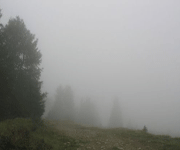
Stratus clouds are located at an altitude of 0.5-0.7 km. A homogeneous, opaque layer of gray color.
Nimbostratus - are located at an altitude of 0.-1.0 km from the ground. A continuous, opaque veil of dark gray color. From such clouds it snows or rains.
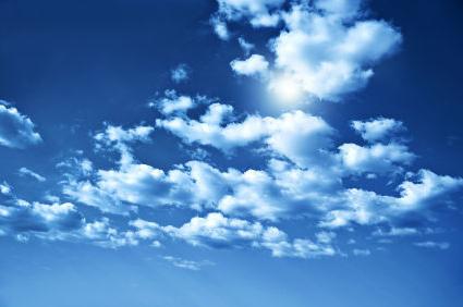
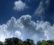
Cumulus clouds - 0.8-1.5 km. They have a gray, flat-looking base and dense, dome-shaped tops that are white. As a rule, there is no precipitation from this type of cloud.
Cumulonimbus clouds - 0.4-1.0 km. It is a whole mass of clouds, which has a dark blue base and a white top. Such clouds bring precipitation - showers, thunderstorms, hail or snow pellets.
Whenever possible, peer into the sky, and you will very soon learn to distinguish not only the shapes, but also the types of clouds.
The concept of “cloudiness” refers to the number of clouds observed in one place. Clouds, in turn, are atmospheric phenomena formed by a suspension of water vapor. The classification of clouds includes many types, divided by size, shape, nature of formation and height of location.
In everyday life, special terms are used to measure cloudiness. Expanded scales for measuring this indicator are used in meteorology, maritime affairs and aviation.
Meteorologists use a cloudiness scale of ten, which is sometimes expressed as a percentage of the visible sky (1 point = 10% coverage). In addition, the height of cloud formation is divided into upper and lower tiers. The same system is used in maritime affairs. Aviation meteorologists use a system of eight octants (parts of the visible sky) with a more detailed indication of the height of the clouds.
A special device is used to determine the lower boundary of the clouds. But only aviation weather stations have an urgent need for it. In other cases, a visual assessment of the height is made.
Cloud types
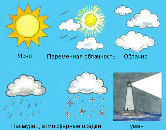
Cloudiness plays an important role in shaping weather conditions. Cloud cover prevents heating of the Earth's surface and prolongs its cooling process. Cloud cover significantly reduces daily temperature fluctuations. Depending on the amount of clouds at a certain time, several types of cloudiness are distinguished:
- “Clear or partly cloudy” corresponds to cloudiness of 3 points in the lower (up to 2 km) and middle tier (2 - 6 km) or any amount of clouds in the upper (above 6 km).
- “Variable or variable” - 1-3/4-7 points in the lower or middle tier.
- “With clearing” - up to 7 points of total cloudiness of the lower and middle tier.
- “Cloudy, cloudy” - 8-10 points in the lower tier or non-transparent clouds in the middle, as well as with precipitation in the form of rain or snow.
Types of clouds
The World Classification of Clouds identifies many types, each of which has its own Latin name. It takes into account the shape, origin, height of formation and a number of other factors. The classification is based on several types of clouds:
- Cirrus clouds are thin filaments of white color. They are located at an altitude of 3 to 18 km depending on latitude. They consist of falling ice crystals, which give them their appearance. Among cirrus clouds at an altitude of over 7 km, clouds are divided into cirrocumulus, altostratus, which have a low density. Below, at an altitude of about 5 km, there are altocumulus clouds.
- Cumulus clouds are dense formations of white color and considerable height (sometimes reaching more than 5 km). They are most often located in the lower tier with vertical development into the middle. Cumulus clouds at the top of the middle layer are called altocumulus.
- Cumulonimbus, shower and thunderclouds, as a rule, are located low above the Earth's surface, 500-2000 meters, and are characterized by precipitation in the form of rain and snow.
- Stratus clouds are a layer of low-density suspension. They transmit light from the sun and moon and are located at an altitude of between 30 and 400 meters.
Cirrus, cumulus and stratus types mix to form other types: cirrocumulus, stratocumulus, cirrostratus. In addition to the main types of clouds, there are other, less common ones: silvery and pearlescent, lenticular and moth-like. And clouds formed by fires or volcanoes are called pyrocumulative.
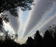
![]() Deformed cirrocumulus clouds.
Deformed cirrocumulus clouds.
Sometimes round shaped breaks can be observed in cirrocumulus clouds. Such a gap forms when the temperature in the cloud is below zero, but the water has not yet frozen. When water in one place begins to freeze, nearby water vapor quickly evaporates and condenses on ice crystals. Ice crystals become heavy and can settle to the ground under their own weight. This is how deformed cirrocumulus clouds are created.
Cirrostratus clouds (Cirrostratus, Cs) are a type of upper level cloud.
Color:
whitish, translucent.
Description and shape of the cloud
.
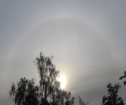
Cirrostratus clouds appear as a continuous veil high in the sky. In the presence of these clouds, the sun and moon float as if in a haze. The transparency of clouds can vary depending on the density of the cloud. At low densities, a halo effect is also observed. The thickness of cirrostratus clouds can reach 2-6 kilometers.
Visibility inside the cloud
: 50-200 meters.
Composition and education.
The source of material for the formation of cirrostratus clouds is entire layers of air rising upward as a result of multi-level convergence. Cloud element – ice crystals.
They do not produce precipitation, but thickening cirrostratus clouds can be a harbinger of bad weather.
What are the different shapes of middle-tier clouds?
altocumulus clouds,
altostratus clouds,
Altostratus translucent clouds.
 Altocumulus clouds (Altocumulus, Ac
Color
: white, gray or bluish white.
Description and shape of the cloud
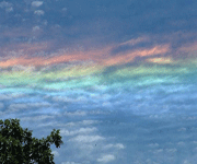
. Altocumulus clouds usually occur in the summer. They are located in waves or in ridges in the form of flakes or plates. There are gaps between individual elements. Sometimes there is a beautiful phenomenon around these clouds called "iridization"
. This is the rainbow coloring of the edge of the cloud.
Visibility inside the cloud
: 50-80 meters.
Composition and education.
Formed when warm air masses rise upward. The rise can be triggered by the onset of a cold front, which displaces air heated at the surface of the earth upward.
Weather forecasting from clouds.
Appear after a thunderstorm or storm. They foretell clear weather.
Altostratus clouds (Altostratus, As) are a type of middle-tier cloud.
Color
: gray or bluish.
Description and shape of the cloud
. Altostratus clouds appear in the form of a uniform or slightly wavy veil, through which the sun and moon faintly shine through. The height of the cloud varies from one to four kilometers.
Visibility inside the cloud
: 25-40 meters.
Composition and education.
The main cloud elements are ice crystals, snowflakes, and supercooled water.
Weather forecasting from clouds.
Precipitation falls from altostratus clouds. This is continuous rain or snow.
 Altostratus translucent clouds (Altostratus translucidus, As trans) - a type of middle-tier cloud
.
Altostratus translucent clouds (Altostratus translucidus, As trans) - a type of middle-tier cloud
.
Color
: white-bluish.
Description and shape of the cloud
. Clearly visible translucent wavy stripes. The solar and lunar disks are quite distinguishable. Despite this, they cast a faint shadow on the ground. The lower boundary of these clouds is at an altitude of 3-5 km. The height of the cloud mass is 1-2 km. Gradually the entire sky is covered with a continuous veil.
Weather forecasting from clouds.
Precipitation also falls from altostratus translucent clouds, but in summer they rarely reach the earth's surface.
What are the different shapes of lower level clouds?
Stratus clouds,
Stratocumulus clouds,
Cumulus clouds.
Stratus clouds (Stratus, St) - a type of lower tier clouds.
Color
: dark gray or light gray.
Description and shape of the cloud
. Stratus clouds appear in the form of a uniform whitish veil that covers the entire sky and looks like fog. The height of the cloud is small - from several tens to hundreds of meters. The lower part can fall very low, and then the cloud merges with fog. Formed in the lower tier of the troposphere.
: 100-400 meters, sometimes drops to 30-90.
Weather forecasting from clouds.
Precipitation sometimes falls from stratus clouds. This is drizzle or snow grains, depending on the season.
 Stratocumulus (Stratocumulus, Sc) - a type of lower level cloud.
Color
: grey.
Description and shape of the cloud
. Stratocumulus clouds come in the form of massive ridges, waves, and plates. They can either have gaps or cover the sky with a continuous wavy veil. The height of the cloud layer is from 200 to 800 meters. Quite dense, the sun shines through only along the edges of the clouds.
Height above ground level
: from 500 to 1800 meters.
Compound
. The main cloud element is water drops.
Weather forecasting from clouds.
Precipitation is possible only occasionally, and even then short-lived.
Stratocumulus clouds.
Color
: grey.
Description and shape of the cloud
. A type of stratocumulus cloud. They are notable for the fact that they are located in the sky in the form of regular rows or waves, separated by gaps.
Height above ground level
: from 500 to 1800 meters.
Compound
. Cloud element - water drops.
Weather forecasting from clouds.
Most often they foretell good weather.
 Cumulus clouds (Cumulus, Cu) - type of lower clouds.
Color
: bright white.
Description and shape of the cloud
. Dense, elongated clouds. The upper part of cumulus clouds is round or in the form of round towers.
Height above ground level
: from 800 to 1500 meters, occasionally more than two kilometers.
Weather forecasting from clouds.
If they are located scattered, far from each other, then the weather is good. But if the cumulus clouds are large and multi-story, then there may be heavy rain.
What are the different shapes of vertical development clouds:
nimbostratus clouds,
Cumulonimbus clouds.
Nimbostratus clouds (Nimbostratus, Ns) - a type of cloud with vertical development.
Color
: dark gray, with a bluish tint.
Description and shape of the cloud
. Clouds cover the earth with a continuous veil. Nimbostratus clouds have a heterogeneous structure, sometimes wavy. The layer thickness is up to several kilometers. They differ from stratus clouds by their heterogeneous structure, which becomes blurred during rain or snow. But in the intervals between precipitation, the heterogeneity becomes visible again.
Height above ground level
: from 100 to 1900 meters.
Weather forecasting from clouds.
Prolonged precipitation occurs.
 Cumulonimbus (Cb) - type of clouds of vertical development
.
Cumulonimbus (Cb) - type of clouds of vertical development
.
Color
: thick dark grey.
Description and shape of the cloud
. Powerful dense clouds reaching a height of more than 10 km. The clouds are preceded by a squally wind, a hurricane. They are distinguished by a flat top - an “anvil”, consisting of ice crystals.
Height above ground level
: up to 2000 meters.
Compound
. At the base there are water drops, and at the top, where the temperature is much lower, there are ice crystals.
Weather forecasting from clouds.
Cumulonimbus clouds are a harbinger of bad weather. They bring heavy rain, thunderstorms, and possible hail.
This completes the listing of the main types and the shape of clouds, but there are other, rarer types. They cannot be classified into any of the categories described above, so they are considered separately. In the next article we will answer the question: What other clouds are there?
It was an article "Types and forms of clouds. What types of clouds are there?" Read further:
Cloud as a natural phenomenon(Abstract written by a 10th grade student)
V. Dahl's explanatory dictionary gives a short and at the same time quite accurate definition of a cloud: “Cloud is fog in the air.” Like fog, a cloud is a suspension of small and minute droplets of water in the air. Along with water droplets, the cloud may also contain small ice crystals. The cloud may consist entirely of such crystals.
Clouds also differ from each other in their apparent thickness, height above the ground, area of distribution and color. In a word, their diversity is great.
Cloud classification
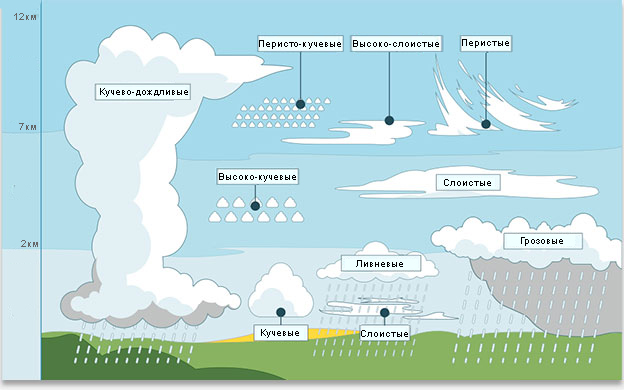
According to the international classification, clouds are divided into 10 main forms by appearance, and into 4 classes by height.
1. Upper clouds– located at an altitude of 6 km and above, they are thin white clouds, consist of ice crystals, have little water content, so they do not produce precipitation. The thickness is small - 200 - 600 m. These include:
feathery clouds that look like white threads, hooks. They are harbingers of worsening weather and the approach of a warm front (Fig. 2d);
cirrocumulus clouds - small white flakes, small white flakes, ripples;
cirrostratus have the appearance of a bluish uniform veil that covers the entire sky, a blurry disk of the sun is visible, and at night a circle of halo appears around the moon.
2. Mid-level clouds– located at an altitude of 2 to 6 km, consisting of supercooled drops of water mixed with snowflakes and ice crystals. These include:
altocumulus, having the appearance of flakes, plates, waves, ridges, separated by gaps. The vertical length is 200 - 700 m, no precipitation falls (Fig. 2 c);
high-stratified They represent a continuous gray veil, thin high-layered ones have a thickness of 300 - 600 m, and dense ones - 1 - 2 km. In winter, they receive heavy precipitation.
3. Low clouds They range from 50 to 2000 m and have a dense structure. These include:
nimbostratus, having a dark gray color, high water content, produce abundant continuous precipitation. Below them, low, broken-rain clouds form in the precipitation. The height of the lower boundary of nimbostratus clouds depends on the proximity of the front line and ranges from 200 to 1000 m, the vertical extent is 2 - 3 km, often merging with altostratus and cirrostratus clouds;
stratocumulus consist of large ridges, waves, plates separated by gaps. The lower limit is 200 - 600 m, and the thickness of the clouds is 200 - 800 m, sometimes 1 - 2 km. These are intramass clouds; the upper part of stratocumulus clouds has the highest water content. As a rule, precipitation does not fall from these clouds (Fig. 2 b);
layered the clouds are a continuous, homogeneous cover, hanging low above the ground with jagged, blurry edges. The height is 100-150 m and below 100 m, and the upper limit is 300-800 m. They can descend to the ground and turn into fog (Figure 2 a);
broken-laminated clouds have a lower limit of 100 m and below 100 m, they are formed as a result of the dispersion of fog. Precipitation does not fall from them.
4. Clouds of vertical development. Their lower boundary lies in the lower tier, the upper reaches the tropopause. These include:
cumulus clouds are dense cloud masses developed vertically with white dome-shaped tops and a flat base. Their lower limit is about 400 - 600 m and higher, their upper limit is 2 - 3 km, they do not give precipitation (Fig. 2e);
powerful-cumulus the clouds are white dome-shaped peaks with a vertical development of up to 4 - 6 km; they do not produce precipitation;
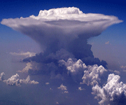
cumulonimbus (thunderstorms) are the most dangerous clouds, they are powerful masses of swirling clouds with a vertical development of up to 9 - 12 km. They are associated with thunderstorms, showers, and hail (Figure 2 f, g).
Clouds are carried by winds over vast distances, resulting in constant moisture exchange between different areas of our planet. An extremely simplified scheme of moisture exchange is as follows: water from the sea enters the clouds that form above the surface of the sea, then the winds carry these clouds to the mainland, where they rain, and finally, through the rivers, the water returns back to the sea. 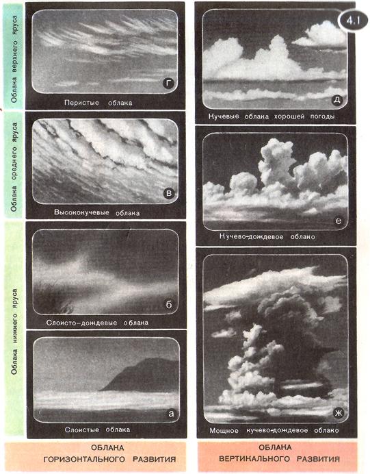
The cloud cover of our planet is quite large. Clouds cover on average about half of the entire sky. They contain 10-12 kg of water (ice) in suspension.
Depending on the causes of occurrence, the following types of cloud forms are distinguished:
Cumuliformes . The reason for their occurrence is thermal, dynamic convection and forced vertical movements. These include: a) cumulus b) cumulonimbus c) altocumulus d) altocumulus e) cirrocumulus
Layered arise as a result of upward sliding of warm moist air along the inclined surface of cold air along flat frontal sections. This type of cloud includes: a) nimbostratus b) altostratus c) cirrostratus d) cirrus
Wavy occur during wave oscillations on inversion layers and in layers with a small vertical temperature gradient. These include: a) stratocumulus b) altocumulus, undulate c) stratus d) stratus fractus.
There is another important characteristic - cloudy, i.e. number of clouds - the number of conventional parts of the sky covered by clouds. Previously, this number was expressed in points (from 0 to 10), but now it is customary to express it in octants (from 0 to 8).
In Figure 1, the listed types of clouds are schematically depicted together, which allows us to imagine the structure of cloud cover as a whole. All of these clouds form within the lower layer of the atmosphere called the troposphere. In the higher layers of the atmosphere there are almost no clouds; only at altitudes of about 30 km can one detect pearly clouds yes at altitudes of about 80 km - noctilucent clouds. Mother-of-pearl clouds are very thin, they are translucent; at dusk near the sun they turn red, golden and greenish. Noctilucent clouds are also very thin. They glow silver at night, shortly after sunset or shortly before sunrise. This is sunlight scattered by clouds.
The structure of the earth's atmosphere. In a certain sense, the earth's atmosphere can be likened to a layer cake; it consists of a number of layers or, more precisely, a number of spheres nested one within the other. The division into layers (spheres) is carried out taking into account the nature of the change in atmospheric air temperature with height. Figure 3 highlights four layers of the atmosphere troposphere, stratosphere, mesosphere, hermosphere- and shows a curve reflecting the change in air temperature with height. 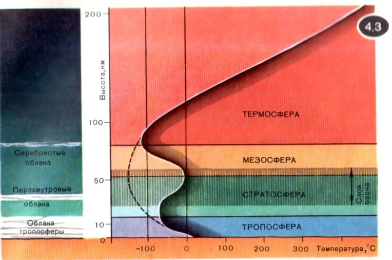
As you rise from the surface of the earth, the air temperature first decreases. Everyone knows this - after all, the tops of high mountains are covered with snow and ice all year round. Anyone who has flown on airliners has repeatedly heard flight attendants report that the air temperature outside the plane is 60-70 degrees below zero. Let us remind you that modern airliners fly at altitudes of 8-10 km.
It turns out that a decrease in air temperature with height occurs only up to certain altitudes of up to 17 km above the tropics and 10 km above the polar regions. These numbers precisely determine the height of the upper boundary of the troposphere (it depends on the geographic latitude). The air temperature at the boundary of the troposphere is about -75°C over the tropics, and about -60°C over the poles.
The stratosphere is adjacent to the troposphere. In the stratosphere, the air temperature during ascent initially remains constant (up to altitudes of 25 - 30 km), and then begins to increase - up to a height of 55 km, corresponding to the upper boundary of the stratosphere; in this case, the temperature reaches values close to 0°C. In the next atmospheric layer, the mesosphere, the temperature again begins to decrease as it rises; it drops to -100°C and even to -150°C at the level of the upper boundary of the mesosphere, which has a height of about 80 km. The thermosphere begins even higher; here the temperature increases as it rises.
So, in the troposphere the air temperature decreases with height, in the stratosphere the temperature first does not change and then increases, in the mesosphere it decreases again and, finally, in the thermosphere it begins to increase again. Note that the word "troposphere" comes from the Greek "tropos", meaning "turn"; The first temperature change occurs above the troposphere. The atmosphere really resembles a layer cake: layers where the temperature drops alternate with layers where it rises.
The origin of this “layer cake” is not difficult to explain. After all, the atmosphere is heated from below by the earth's surface, and from above by solar radiation; therefore, its temperature should increase as it approaches both the surface of the earth and the upper boundary of the atmosphere. As a result, the temperature curve should seem to have the form shown in Figure 3 by the dotted line. In reality, the temperature changes with height not along a dotted line, but along a continuous line and shows a slight increase in the stratosphere. This increase in temperature is caused by the absorption of the ultraviolet component of solar radiation in the ozone layer (O 3), which occupies an altitude range of approximately 20 to 60 km.
For clouds to form, the air must be moist (or at least not too dry) and there must be a sufficiently strong drop in air temperature. The most humid air is near the earth's surface, in the troposphere. In addition, in the troposphere, the air temperature decreases with height. Therefore, it is not surprising that almost all of the Earth's cloud cover is concentrated within the troposphere. Noctilucent clouds form significantly above the troposphere - near the upper boundary of the mesosphere. It is significant that at these altitudes the temperature curve passes through another and, moreover, relatively strong minimum. Note that at altitudes near the maximum of the temperature curve (at the boundary of the stratosphere and mesosphere), clouds are never observed.
Adiabatic expansion of gas
One of the main processes leading to the formation of a cloud is the process adiabatic expansion of air as it rises above the surface land.
Suppose that a certain mass of gas (in particular, air) expands. In this case, the gas does work A against external pressure forces. Let Q be the heat that the gas receives from outside during the expansion process. Work done by gas A and the heat Q received by it determine the change in the internal energy of the gas ∆ U:
∆U = Q - A. (1)
This is the first law of thermodynamics; it represents nothing more than the law of conservation of energy for the mass of gas in question.
A change in the internal energy of a gas is associated with a change in its temperature. Let T 1 And T 2 - the initial and final gas temperatures, respectively. We will assume that the gas consists of diatomic molecules and that its molar mass is M(for air you can take M=0.029 kg/mol). For such a gas
Where m - gas mass, kg; R - universal gas constant, R=8,3 · J/(mol K); M– molar mass, kg/mol.
If Q > A, That ∆ U > 0. In this case T 2 > T 1 Therefore, the gas heats up as it expands. If Q = A, That ∆ U = 0. In this case T 2 = T 1 - the temperature of the expanding gas remains unchanged (isothermal expansion).
We are interested in the case when we can accept Q = 0, i.e. when the heat exchange between the gas and its environment can be neglected. In this case, relation (1) takes the form
∆U= - A.(3)
It is clear that now ∆ U < 0 и, следовательно, T 2 < T 1 -gas cools as it expands.
The process in question is called adiabatic expansion gas With such expansion, the gas does not receive heat from the outside and therefore does work only due to its own internal energy (as a result of which it cools). Substituting (2) into (3), we obtain a formula relating the decrease in temperature of an adiabatically expanding diatomic gas and the work done by the gas:
Let us present without derivation the formula for the work of an adiabatically expanding diatomic gas:
Here p 1 And T 1 - initial pressure and initial temperature of the gas, and p 2 - its final pressure.
Using the last two formulas, we find that with adiabatic expansion, the air cools by 6 degrees when rising 1 km. Adiabatic air temperature gradient
γ a = 0.6 o C/100 m.
ABOUTeducationclouds
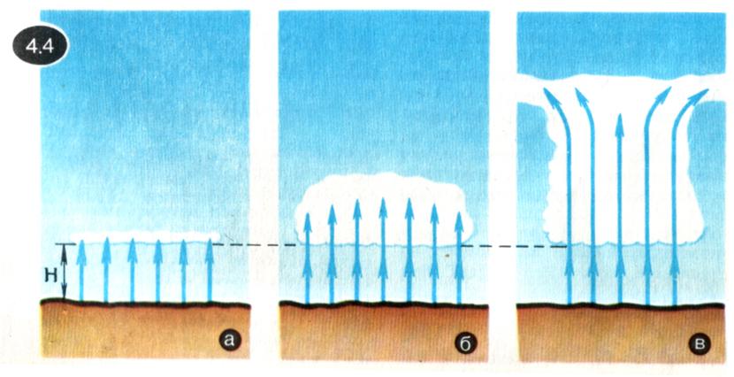
The process of cloud formation begins with the fact that a certain mass of sufficiently moist air rises upward. As we rise there will be expansion of air. This expansion can be considered adiabatic, since the air rises relatively quickly, and if its volume is sufficiently large (and a really large volume of air takes part in the formation of the cloud), the heat exchange between the air in question and the environment during the rise simply does not have time to occur.
As we already know, during adiabatic expansion of a gas its temperature decreases. Means, the rising moist air will cool. When the temperature of the cooling air drops to the dew point, the process of condensation of the steam contained in the air becomes possible. If there is a sufficient number of condensation nuclei (dust grains, ions) in the atmosphere, this process actually begins. If there are few condensation nuclei in the atmosphere, condensation begins not at a temperature equal to the dew point, but at lower temperatures.
So, having reached a certain height N, the rising moist air will cool (as a result of adiabatic expansion) so much that water vapor will begin to condense. Height N there is a lower one border of the forming cloud (Fig. 4a). The air that continues to flow from below passes through this boundary, and the process of vapor condensation will occur above this boundary - the cloud will begin to develop in height (Fig. 4b). The vertical development of the cloud will stop when the air stops rising; this will form upper limit clouds (Fig. 4c).
Now let's consider what makes air rise up.
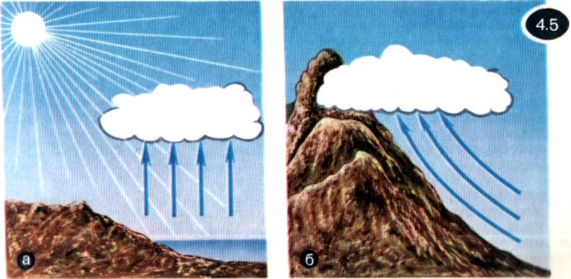
Firstly, the rise of air masses can occur due to convection - when on a hot day the sun's rays strongly warm the earth's surface, and it transfers heat to the ground layers of air (Fig. 5, a). In this case, they talk about clouds of convection origin. Cumulus clouds most often have this exact origin.
Secondly, blowing in a horizontal direction along the surface of the earth, the wind can encounter mountains or other natural elevations on its path. Flowing around them, the wind will move air masses upward (Fig. 5, b). These are also intramass clouds. Stratus and nimbostratus clouds may have this origin.
Third, clouds form on warm and cold fronts. If masses of warm air, moving horizontally, crowd out cold air, the so-called warm front. If cold air sets in, then they talk about cold
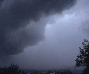
front. The warm front is depicted schematically in Figure 6, a, where red arrows show the movement of warm air, and black arrows show the movement of cold air. Near the boundary between warm and cold air masses, rising air currents (both warm and cold) arise. As a result, clouds of horizontal development of all tiers can form - nimbostratus, altocumulus, cirrus. Figure 6b shows a cold front. Here, rising currents of only warm air are formed. In this case, as on a warm front, clouds of all levels are formed. So, on a warm front, the advancing warm air, as it were, “falls” on the cold air creeping below and rises up along it. On a cold front, the advancing cold air penetrates under the warm air and, as it were, lifts it. 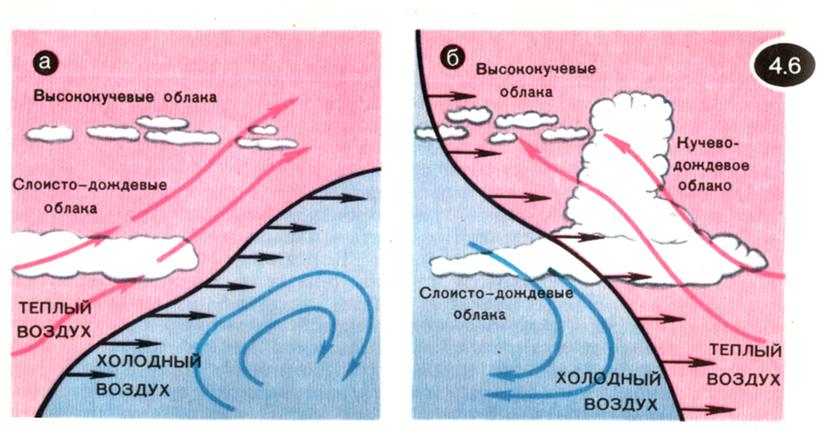
Fourth, vertical movements of air masses can be associated with cyclonic activity, which, in turn, is associated with the interaction of warm and cold fronts.
Cyclones and anticyclones They are powerful atmospheric vortices with a diameter of up to several thousand kilometers and a height of 10...20 km.
Cyclones. Near the surface of the earth, winds are directed from the periphery to the center of the cyclone, since the air pressure at the center of the cyclone is less than at its periphery. In the Northern Hemisphere, winds “spin” towards the center of the cyclone counterclock-wise, and in South - clockwise arrow. In Figure 7a, the cyclone isobars at the earth's surface are shown in red; blue arrows show the direction of the winds (for the Northern Hemisphere). The air masses flowing towards the center of the cyclone then rush vertically upward (Fig. 76). This leads to the formation of powerful stratus and nimbostratus clouds, and precipitation occurs. In the upper troposphere, horizontal winds arise, directed in a spiral from the center of the cyclone; they carry air masses captured by the cyclone to its periphery. The origin or arrival of an already formed cyclone always leads to a significant deterioration in the weather, accompanied by prolonged rains.
We feel the approach of the central region of the cyclone by the decrease in atmospheric pressure. We say: “The pressure has dropped - it will rain, it will be cloudy.” 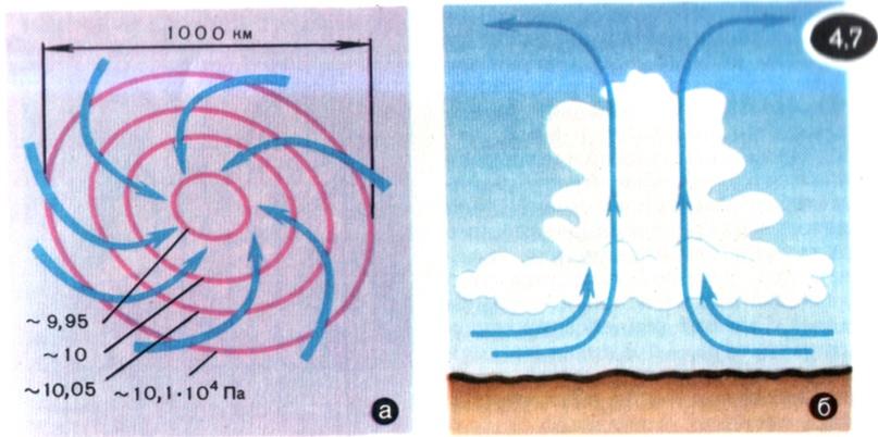
Anticyclones. Anticyclones are characterized by the opposite picture of processes. At the center of the anticyclone, the pressure is higher than at the periphery. In the upper troposphere, the winds “spin” towards the center of the anticyclone, and near the earth’s surface - from the center; powerful downward air currents arise in the center. The descending air heats up, relative humidity decreases, cloudiness disappears - clear weather sets in. It is not without reason that we rightly associate an increase in atmospheric pressure with improved weather.
The physical nature of a cumulus cloud.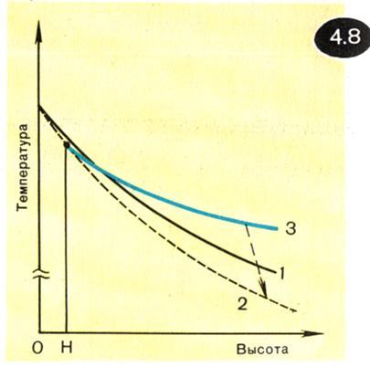
Let us dwell in a little more detail on the physics of the processes leading to the formation of an ordinary cumulus cloud of convection origin. Such a cloud has significant vertical dimensions, indicating that convection currents can rise to a great height - significantly above the lower boundary of the cloud. For an explanation, let us turn to Figure 8. It shows (qualitatively) three dependences of air temperature on altitude. Dependence 1 refers to air that does not participate in cloud formation. This air surrounds the cloud from the sides; we will assume that there are no vertical flows in it. The drop in temperature with height reflects in this case the natural course of the temperature curve within the troposphere. Relationship 2 refers to rising (and therefore adiabatically expanding) dry air. During adiabatic expansion, the air cools, so temperature curve 2 drops more steeply than curve 1. It should, however, be borne in mind that in reality it is not dry air that rises, but moist air; As a result of air cooling, the steam contained in it will condense (starting from a certain height N, fixing the lower boundary of the cloud). When steam condenses latent heat of vaporization is released. The amount of heat released turns out to be quite noticeable. This leads to the fact that the temperature of rising moist air will decrease with height more slowly than even the temperature of still air (temperature curve 3). This circumstance is very important. In fact, taking into account the condensation of steam, the temperature of the rising air decreases, while remaining at the same time higher than the temperature of the surrounding still air. The fact that the cooling air remains hotter than its surroundings, provides the ability to continue to rise higher and higher. As a result, a significant development of the cloud occurs in the vertical direction.
Of course, such development cannot be unlimited. As water vapor condenses, the air becomes less and less humid; it is getting more and more dry. Therefore, temperature dependence 3 is no longer realized; a transition occurs to dependence 2, corresponding to dry air (this transition is conventionally shown in Figure 8 by a dashed arrow). As a result of this transition, the temperature of the rising air at some height will be equal to the temperature of the surrounding air and even be slightly lower than it. As a result, the vertical development of the cloud will stop; cold masses of air that have given up their moisture to the cloud will begin to spread out to the sides and fall down around the cumulus cloud, forming the winglets characteristic of such clouds.
Macrophysics and microphysics of clouds
There are macrophysics and microphysics of clouds. Macrophysics studies the movements of air masses leading to the formation, growth and evaporation of the cloud as a whole. Microphysics examines the microstructure of the cloud, studies the processes of formation, merger, and evaporation of water droplets. In particular, microphysics studies the conditions for the formation of certain sediments.
Clouds can consist of water droplets (water or drip clouds), ice crystals (ice or crystalline clouds), and also both droplets and crystals (mixed clouds). Water clouds exist not only at above-zero temperatures, but also at temperatures below zero (down to about -20 o C) these are supercooled water clouds. For example, at -10°C the clouds are water in 50% of cases, mixed in 30% and ice in only 20%.
Water droplets in the cloud have different diameters - from fractions of a micrometer to several millimeters. Ice crystals of the cloud most often have the form of hexagonal prism-columns about 0.1 mm long and hexagonal plates measuring 0.1...0.5 mm.
No matter how small an ice drop is, it is still significantly heavier than air. Therefore, the question arises: how do water drops (and at the same time the cloud as a whole) kept in the air? At the same time, another question arises: under what conditions do water drops stop holding on in the air and fall to the ground as rain?
Let's start with the smallest droplets, the radius of which is a fraction of a micrometer. Such droplets are prevented from falling down by random impacts from air molecules in chaotic thermal motion. These impacts cause the droplet to bounce in a variety of directions; as a result, it moves along a bizarrely broken trajectory (Brownian motion).
The more massive the drop, the more difficult it is for air molecules to throw it away and, therefore, the less the role of Brownian motion, but the greater the influence of gravity. When the radius of a drop becomes larger than a micrometer, its motion ceases to be Brownian; the drop begins to fall under the influence of gravity. And then a new factor “comes into play” that prevents the drop from falling down - air resistance. environment.
Let at some point in space a water drop with a radius R (let, for example, R=10 µm). At this moment in time, only the force of gravity P acts on the drop
where ρ 0 is the density of water, g - gravitational acceleration (– droplet volume). Under the influence of gravity, the drop begins to fall down and its speed begins to increase. At the same time, the air resistance force acting on the drop arises and begins to grow F. It is directed opposite to gravity and proportional to the speed of the drop u:
F = 6π η Ru, (7)
Where η - air viscosity coefficient. ( Viscosity, or, otherwise, internal friction - the property of gases and liquids to resist the movement of one part relative to another; for this reason, for example, the speed of gas or liquid flow in a pipe decreases when moving from the axis of the pipe to its walls.) As the resistance force increases F the difference decreases R- F, therefore, the speed of the falling drop increases more and more slowly. When the force of air resistance is equal in magnitude to the force of gravity, further increase in drop speed will stop and then the drop will fall uniformly (after all, now the resultant force applied to the drop is zero: R -F = 0) . Speed of uniform drop movement u determined from the condition R -F= 0 s taking into account (6) and (7):
A uniformly falling drop can be stopped and even thrown upward by an ascending air flow if the vertical velocity of the flow is greater than the speed of the drop's fall.
It is not at all easy to answer the question of why the cloud does not fall to the ground. There is a lot to consider here: thermal movement molecules air, air resistance, evaporation of droplets. A number of other factors must also be taken into account. Thus, it should be borne in mind that as the radius of the drop increases, the force of air resistance begins to play an increasingly significant role due to the fact that relatively large drops (with a radius of more than 100 μm) when falling cause turbulent movements in the air. It should also be taken into account that during the fall, the radius of the drop does not remain unchanged at all: along with evaporation, additional condensation of steam occurs on the surface of the drop, increasing its radius. It is also possible for a given drop to merge with other drops or, conversely, to break it up into several smaller drops. In short, cloud microphysics turns out to be quite complex.
As children, we often watch clouds, marveling at how soft, fluffy they are, like a down pillow. We want to understand what kind of magical substance forms this light and at the same time dense structure, so changeable that in a few minutes it turns from a giraffe to a fox or from a ship to an airplane.
Clouds are formed from microscopic water droplets and ice crystals. As you know, most of the earth's surface consists of water; this water constantly evaporates under the influence of heat. When water vapor reaches the upper atmosphere, it cools, forming cold water droplets and tiny pieces of ice. The accumulation of these droplets and pieces of ice is clouds.
They can vary in color, the color of the clouds determines their density and how the sun illuminates them. They also constantly move and change their shape under the influence of the wind - it’s not for nothing that clouds are called heavenly wanderers. Scientists divide clouds into several types:
Cirrus clouds live at an altitude of 6-10 kilometers from the earth's surface. They consist of ice crystals and are snow-white in color. These clouds are not too dense, as if torn, they are harbingers of the appearance of clouds.
Cirrostratus clouds also consist of ice crystals, but unlike cirrus clouds, they form a continuous white veil.
Altostratus clouds are lower than cirrus clouds; they are located at an altitude of 3-5 km from the ground. They contain not only crystal ice, but also drops of water, and even snowflakes, so rain or snow can fall from such clouds.
Nimbostratus are gray, low clouds that carry not only precipitation, but also strong winds and cold weather.
Gray stratus clouds cover the entire sky on a cloudy day. They hang at an altitude of 50 m to 2 km above the earth's surface. Most often they produce light, drizzling rain.
Cirrocumulus clouds are often called “lamb clouds.” They swim at an altitude of 6-8 km and, as a rule, foretell the approach of a thunderstorm.
Altocumulus clouds are typical for the warm season. They can be gray, white and even bluish; they foam in waves and ridges, separated by gaps.
Stratocumulus gray clouds are made of water droplets. Although they look like dense blocks, they do not foretell precipitation.
Cumulus clouds resemble a snow cap. In summer they bring with them showers, and in winter they bring snowfall.
Cumulonimbus clouds are powerful and dense, foreshadowing thunderstorms, rain and hail.
The lightness and beauty of clouds often inspire poets to use their image as a symbol of something incredibly tender, airy and sometimes unattainable. Thus, Vladimir Mayakovsky, wanting to convey how rough simplicity can be combined with tender lyrics, and, essentially revealing his true nature to the reader, calls himself not a man, but a cloud in his pants in the poem of the same name.
Image source: userapi.com