A short story about the earthquake. Geosciences
Full text search:
Home > Abstract >Life safety
Ryazan State University named after S. A. Yesenin
Abstract on the topic: “Earthquakes”
1st year students
GMU groups 12
Alina Khammatova
2.1 Types of seismic waves
2.2 Measuring the strength and impacts of earthquakes
2.2.1 Magnitude scale
2.2.2 Intensity scales
2.2.2.1 Medvedev-Spohnheuer-Karnik scale (MSK-64)
4.1 Seismograph
4.2 Earthquake forecasting station ATROPATENA
4.3 Tectometer
5.1 Volcanic earthquakes
5.2 Man-made earthquakes
5.3 Landslide earthquakes
5.4 Earthquakes
1. Introduction
2 Seismic waves and their measurement
2.3 What happens during strong earthquakes
3 Causes of earthquakes
4 Measuring instruments
5 Other types of earthquakes
6 Most destructive earthquakes
7 Literature
Introduction
The cause of an earthquake is the rapid displacement of a section of the earth's crust as a whole at the moment of plastic (brittle) deformation of elastically stressed rocks at the source of the earthquake. Most earthquakes occur near the Earth's surface
Earthquakes- tremors and vibrations of the Earth's surface caused by natural causes (mainly tectonic processes) or artificial processes (explosions, filling of reservoirs, collapse of underground cavities in mine workings). Small tremors can also cause lava to rise during volcanic eruptions.
About a million earthquakes occur throughout the Earth each year, but most are so small that they go unnoticed. Really strong earthquakes, capable of causing widespread destruction, occur on the planet about once every two weeks. Fortunately, most of them occur on the bottom of the oceans, and therefore are not accompanied by catastrophic consequences (if an earthquake under the ocean does not occur without a tsunami).
Earthquakes are best known for the devastation they can cause. Destructions of buildings and structures are caused by soil vibrations or giant tidal waves (tsunamis) that occur during seismic displacements on the seabed.
The International Earthquake Observation Network records even the most distant and low-magnitude ones.
Seismic waves and their measurement
The sliding of rocks along a fault is initially prevented by friction. As a result, the energy causing movement accumulates in the form of elastic stresses in the rocks. When the stress reaches a critical point exceeding the friction force, a sharp rupture of the rocks occurs with their mutual displacement; the accumulated energy, when released, causes wave vibrations of the earth's surface - earthquakes. Earthquakes can also occur when rocks are compressed into folds, when the magnitude of the elastic stress exceeds the tensile strength of the rocks, and they split, forming a fault.
Seismic waves generated by earthquakes propagate in all directions from the source like sound waves. The point at which rock movement begins is called focus, hearth or hypocenter, and a point on the earth’s surface above the source is epicenter earthquakes. Shock waves propagate in all directions from the source; as they move away from it, their intensity decreases.
Seismic wave velocities can reach 8 km/s.
Types of seismic waves
Seismic waves are divided into compression waves And shear waves.
Compression waves, or longitudinal seismic waves, cause vibrations of the rock particles through which they pass along the direction of wave propagation, causing alternating areas of compression and rarefaction in the rocks. The speed of propagation of compression waves is 1.7 times greater than the speed of shear waves, so seismic stations are the first to record them. Compression waves are also called primary(P-waves). The speed of the P-wave is equal to the speed of sound in the corresponding rock. At frequencies of P-waves greater than 15 Hz, these waves can be perceived by ear as an underground hum and rumble.
Shear waves, or seismic transverse waves, cause rock particles to vibrate perpendicular to the direction of propagation of the wave. Shear waves are also called secondary(S-waves).
There is a third type of elastic waves - long or superficial waves (L-waves). They are the ones who cause the most destruction.
Measuring the strength and impacts of earthquakes
A magnitude scale and an intensity scale are used to evaluate and compare earthquakes.
Magnitude scale
The magnitude scale distinguishes earthquakes by magnitude, which is the relative energy characteristic of the earthquake. There are several magnitudes and, accordingly, magnitude scales: local magnitude (ML); magnitude determined from surface waves (Ms); body wave magnitude (mb); moment magnitude (Mw).
The most popular scale for estimating earthquake energy is the local Richter magnitude scale. On this scale, an increase in magnitude by one corresponds to a 32-fold increase in the released seismic energy. An earthquake with a magnitude of 2 is barely noticeable, while a magnitude of 7 corresponds to the lower limit of destructive earthquakes covering large areas. The intensity of earthquakes (cannot be assessed by magnitude) is assessed by the damage they cause in populated areas.
Intensity scales
Intensity is a qualitative characteristic of an earthquake and indicates the nature and scale of the impact of earthquakes on the surface of the earth, on people, animals, as well as on natural and artificial structures in the earthquake area. Several intensity scales are used in the world: in the USA - the Modified Mercalli scale (MM), in Europe - the European Macroseismic Scale (EMS), in Japan - the Shindo scale.
Medvedev-Sponheuer-Karnik scale (MSK-64)
The 12-point Medvedev-Sponheuer-Karnik scale was developed in 1964 and became widespread in Europe and the USSR. Since 1996, the European Union has used the more modern European Macroseismic Scale (EMS). MSK-64 is the basis of SNiP II-7-81 “Construction in seismic areas” and continues to be used in Russia and the CIS countries. In Kazakhstan, SNiP RK 2.03-30-2006 “Construction in seismic areas” is currently used.
|
Point |
Earthquake strength |
a brief description of |
|
Not felt |
Marked only by seismic instruments. |
|
|
Very weak tremors |
Marked by seismic instruments. It is felt only by certain people who are in a state of complete peace in the upper floors of buildings, and by very sensitive pets. |
|
|
It is felt only inside some buildings, like a shock from a truck. |
||
|
Moderate |
Recognized by slight rattling and vibration of objects, dishes and window glass, creaking of doors and walls. Inside the building, most people feel the shaking. |
|
|
Quite strong |
In the open air it is felt by many, inside houses - by everyone. General shaking of the building, vibration of furniture. The clock pendulums stop. Cracks in window glass and plaster. Awakening the Sleepers. It can be felt by people outside buildings; thin tree branches are swaying. Doors slam. |
|
|
It is felt by everyone. Many people run out into the street in fear. Pictures fall from the walls. Individual pieces of plaster are breaking off. |
||
|
Very strong |
Damage (cracks) in the walls of stone houses. Anti-seismic, as well as wooden and wicker buildings remain unharmed. |
|
|
Destructive |
Cracks on steep slopes and wet soil. Monuments move out of place or topple over. Houses are heavily damaged. |
|
|
Devastating |
Severe damage and destruction of stone houses. Old wooden houses are crooked. |
|
|
Destructive |
Cracks in the soil are sometimes up to a meter wide. Landslides and collapses from slopes. Destruction of stone buildings. Curvature of railway rails. |
|
|
Catastrophe |
Wide cracks in the surface layers of the earth. Numerous landslides and collapses. Stone houses are almost completely destroyed. Severe bending and bulging of railway rails. |
|
|
Major disaster |
Changes in the soil reach enormous proportions. Numerous cracks, collapses, landslides. The appearance of waterfalls, dams on lakes, deviation of river flows. Not a single structure can withstand. |
Causes of earthquakes
The earth's interior is in constant motion. Low-frequency waves (periods of seconds or more) propagate in the earth's crust. You can call fluctuations minute, hourly, daily, annual. The waves propagating across the earth's crust are enormous. Wavelength over 1000 km. The vibration amplitudes are hundreds of meters. These waves contain enormous energy. Due to inhomogeneities in the earth's crust, oscillations of similar frequencies arise, which begin to interfere with each other, which leads to the formation of resonant oscillations at some points of the earth's crust and suppression of oscillations at others - “beating”. There is a redistribution of vibration energy over the Earth's surface.
Earthquakes occur at those points where the earth's surface cannot respond plastically to a multiple increase in the amplitude of vibrations.
The theory of “stress accumulation” cannot explain the mechanism of conservation and retention of energy before an earthquake.
An obvious way to predict is to monitor long-period oscillations in different parts of the planet (including using gravimeters) and respond to a multiple increase in the amplitude of oscillations in problem areas.
The presence of radial (as well as tangential) displacements of the earth’s crust, not catastrophic, “plastic” (without destruction of the earth’s crust) can cause a failure of the navigation system in air transport or a sudden departure into the oncoming lane of a car moving at high speed
Measuring instruments
Seismograph
Seismograph
Main article: seismograph
To detect and record all types of seismic waves, special instruments are used - seismographs. In most cases, the seismograph has a weight with a spring attachment, which during an earthquake remains motionless, while the rest of the device (body, support) begins to move and shifts relative to the load. Some seismographs are sensitive to horizontal movements, others to vertical ones. The waves are recorded by a vibrating pen on a moving paper tape. There are also electronic seismographs (without paper tape).
Earthquake forecasting station ATROPATENA]

Station Atropatena Crystal (KH20) - Technology Brand (Azerbaijan)
The ATROPATENA forecasting station automatically and autonomously records three-dimensional changes in the gravitational field and transmits this information to the Central Database located in the USA (La Habra). Since 2007, after the start of operation of the first ATROPATENA-AZ station, short-term earthquake forecasts were regularly received by the Presidium of the MAN (International Academy of Sciences (Health and Ecology)), Austria, Innsbruck), the Pakistan Academy of Sciences (Islamabad, Pakistan) and the Gadjah Mada University (Yogyakarta, Indonesia). In 2009, the Global Network for Earthquake Forecasting (GNFE) began to fully operate in the mode of short-term earthquake forecasting and prompt transmission of this information to countries participating in the Global Network. This fact was widely covered in the Russian and international press. One of the fundamental differences of the new earthquake forecasting technology is that during the forecast, not only the location, strength and time are indicated, but also the number of predicted strong earthquakes. Based on the analysis and interpretation of “gravitogram” records using a special technique, the Research Institute for Forecasting and Studying Earthquakes issues a short-term forecast of strong earthquakes (3-7 days before the shock), which is posted on the website of the Central Database (GNFE)
Tectometer
The tectometer is a device developed in Russia and patented by the State Patent Bureau of Japan (registration number N 07PO369). According to the patent, the device allows you to register an earthquake 40 hours before it starts. The device is compact (fits in a briefcase) and lightweight (about 1 kg).
Other types of earthquakes
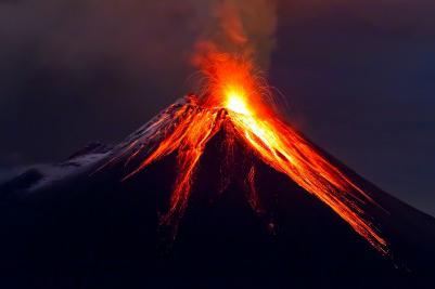
Volcanic earthquakes
Volcanic earthquakes are a type of earthquake in which an earthquake occurs as a result of high tension in the depths of a volcano. The cause of such earthquakes is lava, volcanic gas. Earthquakes of this type are weak, but continue for a long time, many times - weeks and months. However, an earthquake does not pose a danger to people of this type.
Man-made earthquakes
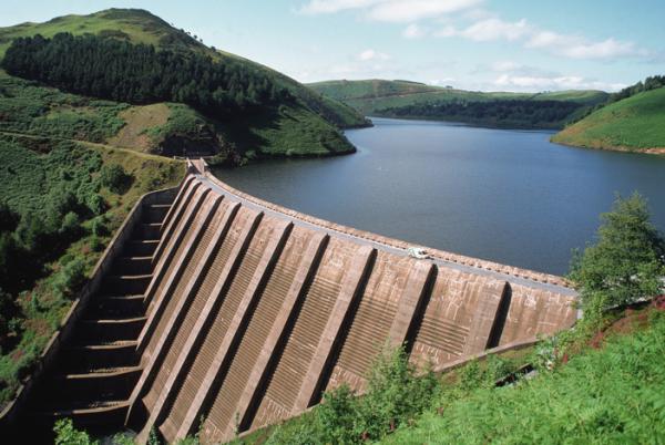
Recently, information has emerged that earthquakes can be caused by human activity. For example, in areas of flooding during the construction of large reservoirs, tectonic activity increases - the frequency of earthquakes and their magnitude increases. This is due to the fact that the mass of water accumulated in reservoirs increases the pressure in rocks with its weight, and seeping water reduces the tensile strength of rocks. Similar phenomena occur when large quantities of rock are removed from mines, quarries, and during the construction of large cities from imported materials.
Landslide earthquakes
Earthquakes can also be caused by landslides and large landslides. Such earthquakes are called landslides; they are local in nature and of low strength.
Earthquakes of artificial nature
Main article: Geophysical weapons
An earthquake can also be caused artificially: for example, by the explosion of a large amount of explosives or by an underground nuclear explosion (tectonic weapon). Such earthquakes depend on the amount of material exploded. For example, when the DPRK tested a nuclear bomb in 2006, a moderate earthquake occurred, which was recorded in many countries.
The most destructive earthquakes

Earthquake in Lisbon in 1755
January 23, 1556 - Gansu and Shaanxi, China - 830,000 people died, more than any other earthquake in human history
1692 - Earthquake in Jamaica - Port Royal turned into ruins
1693 - Sicilian earthquake, killed 60-100 thousand inhabitants, gave rise to the Sicilian Baroque style
1737 - Calcutta, India - 300,000 people died
1755 - Lisbon - 60,000 to 100,000 people died, the city was completely destroyed
1783 - Calabria, Italy - 30,000 to 60,000 people died
1811 - New Madrid, Missouri, USA - the city is reduced to ruins, flooding an area of 500 km²
1887 - Verny (now Alma-Ata), Senior Zhuz, Russian Empire - material losses amounted to about 2.5 million rubles; 1,799 stone and 839 wooden buildings were destroyed
1896 - Sanriku, Japan - the earthquake was centered under the sea. A giant wave washed away 27,000 people and 10,600 buildings into the sea
1897 - Assam earthquake, India - over an area of 23,000 km², the relief was changed beyond recognition, probably the largest earthquake in the history of mankind
December 28, 1908 - Sicily, Italy 83,000 people died, Messina was reduced to ruins (Messina earthquake)
January 4, 1911 (December 22, 1910 old style) - Verny, southern slope of the Trans-Ili Alatau ridge (before 1921 - the name of Alma-Ata), Kazakhstan, Russian Empire - the force was 9 points (magnitude on the Richter scale 8), almost the entire city was destroyed, only isolated buildings, landslides and dams on mountain rivers survived
September 1, 1923 - Great Kanto Earthquake - Tokyo and Yokohama, Japan (8.3 Richter) - 143,000 people died, about a million were left homeless as a result of the resulting fires
1948 - Ashgabat, Turkmen SSR, USSR Ashgabat earthquake - 110,000 people died
July 10, 1949 - Tajik SSR, USSR - as a result of a series of powerful earthquakes, breakaway mountain slopes buried the ancient city of Khait along with the entire population and many other villages, more than 20,000 people died
1950 - The Himalayas devastated an area of 20,000 km² in the mountains
May 21, 1960 - Great Chilean Earthquake, Chile, about 10,000 killed, cities of Concepción, Valdivia, Puerto Montt destroyed
July 26, 1963 - Skopje, Yugoslavia about 2,000 killed, most of the city reduced to ruins
March 28, 1964 - Great Alaska Earthquake, Anchorage, Alaska, USA, most of the city is turned into ruins, large landslides, 300 km of railway destroyed
April 26, 1966 - Tashkent, Uzbek SSR, USSR, Tashkent earthquake - (5.3 Richter) the city was severely destroyed, 8 people died.
February 4, 1976 - Guatemala more than 20,000 people died, more than 1 million people were left homeless
July 28, 1976 - Tangshan, Northeast China, Tangshan earthquake (8.2 Richter) - more than 655,000 people killed
1981 - Sicily is destroyed in many settlements, Mount Etna begins to erupt
September 18, 1985 - Mexico City, Mexico magnitude 8.2 Richter - more than 7,500 people killed
December 7, 1988 - Spitak earthquake: Armenian SSR, USSR - the cities of Spitak, Leninakan and many villages were destroyed, 40,000-45,000 people died. The same number were injured
August 17, 1999 - Izmit earthquake: Turkey, (magnitude - 7.6) killed 17,217 people, 43,959 were injured, about 500,000 were left homeless.
December 26, 2004 - an earthquake in the Indian Ocean, the ensuing tsunami killed 225-250 thousand people.
May 12, 2008 - Sichuan earthquake - earthquake in central China, killing about 70,000 people.
January 12, 2010 - earthquake in Haiti, magnitude 7.0 - occurred 21:53:10 UTC - 220 thousand people died, 300 thousand were injured, 1.1 million lost their homes
February 27, 2010 - Santiago, Chile magnitude 8.8 - occurred at 06:34:14 UTC - at least 799 people killed, more than 1.5 million homes damaged by earthquake and tsunami.
Literature
Zavyalov A.D. Medium-term forecast of earthquakes: fundamentals, methods, implementation. // M.: Nauka, 2006, 254 p.
Sobolev G. A. Fundamentals of earthquake forecasting. M.: Nauka, 1993. 312 p.
Bolt B. A. Earthquakes. M.: Mir, 1981. 256 p.
Yunga S. L. Methods and results of studying seismotectonic deformations. M.: Nauka, 1990. 191 p.
Myachkin V.I. Earthquake preparation processes. M.: Nauka, 1978. 232 p.
Earthquakes in the USSR. M.: Nauka, 1990. 323 p.
Mogi K. Prediction of earthquakes. M.: Mir, 1988. 382 p.
Zubkov S.I. Precursors of earthquakes. // M.: OIPZ RAS. 2002, 140 p.
Richter G.F. Elementary seismology. M., 1963
Rikitake T. Earthquake prediction. M., 1975
Earthquakes
Earthquakes
vibrations of the Earth caused by sudden changes in the condition of the planet's interior. These vibrations are elastic waves propagating at high speed through the rock mass. The most powerful earthquakes are sometimes felt at distances of more than 1,500 km from the source and can be recorded by seismographs (special highly sensitive instruments) even in the opposite hemisphere. The area where vibrations originate is called the earthquake source, and its projection onto the Earth's surface is called the earthquake epicenter. The sources of most earthquakes lie in the earth's crust at depths of no more than 16 km, but in some areas the depths of the sources reach 700 km. Thousands of earthquakes occur every day, but only a few of them are felt by humans.
Mentions of earthquakes are found in the Bible, in the treatises of ancient scientists - Herodotus, Pliny and Livy, as well as in ancient Chinese and Japanese written sources. Until the 19th century Most reports of earthquakes contained descriptions heavily flavored with superstition and theories based on scanty and unreliable observations. A. Perry (France) began a series of systematic descriptions (catalogs) of earthquakes in 1840. In the 1850s, R. Malle (Ireland) compiled a large catalog of earthquakes, and his detailed report on the Naples earthquake in 1857 became one of the first strictly scientific descriptions of large earthquakes.
Causes of earthquakes. Although numerous studies have been carried out since ancient times, it cannot be said that the causes of earthquakes have been fully studied. Based on the nature of the processes at their sources, several types of earthquakes are distinguished, the main ones being tectonic, volcanic and man-made.
Tectonic earthquakes arise as a result of a sudden release of stress, for example, during movement along a fault in the earth’s crust (research in recent years shows that deep earthquakes can also be caused by phase transitions in the Earth’s mantle, occurring at certain temperatures and pressures). Sometimes deep faults come to the surface. During the catastrophic earthquake in San Francisco on April 18, 1906, the total length of surface ruptures in the San Andreas fault zone was more than 430 km, the maximum horizontal displacement was 6 m. The maximum recorded value of seismogenic displacements along the fault was 15 m.
Volcanic earthquakes occur as a result of sudden movements of magmatic melt in the bowels of the Earth or as a result of the occurrence of ruptures under the influence of these movements.
Man-made earthquakes can be caused by underground nuclear tests, filling reservoirs, oil and gas production by injection of liquid into wells, blasting during mining, etc. Less strong earthquakes occur when cave vaults or mine workings collapse.
Seismic waves. Oscillations propagating from the source of an earthquake are elastic waves, the nature and speed of propagation of which depend on the elastic properties and density of rocks. Elastic properties include the bulk modulus, which characterizes the resistance to compression without changing shape, and the shear modulus, which determines the resistance to shear forces. The speed of propagation of elastic waves increases in direct proportion to the square root of the values of the parameters of elasticity and density of the medium.
Longitudinal and transverse waves. These waves appear first on seismograms. The first to be recorded are longitudinal waves, during the passage of which each particle of the medium is first compressed and then expanded again, experiencing reciprocating motion in the longitudinal direction (i.e. in the direction of wave propagation). These waves are also called R- waves, or primary waves. Their speed depends on the elastic modulus and rigidity of the rock. Near the earth's surface speed R-wave is 6 km/s, and at very great depths - approx. 13 km/s. The next to be recorded are transverse seismic waves, also called S-waves, or secondary waves. As they pass, each rock particle oscillates perpendicular to the direction of wave propagation. Their speed depends on the shear resistance of the rock and is approximately 7/12 of the speed of propagation R- waves
Surface waves spread along the earth's surface or parallel to it and do not penetrate deeper than 80-160 km. This group includes Rayleigh waves and Love waves (named after the scientists who developed the mathematical theory of the propagation of such waves). When Rayleigh waves pass through, rock particles describe vertical ellipses lying in the focal plane. In Love waves, rock particles oscillate perpendicular to the direction of wave propagation. Surface waves are often abbreviated as L-waves. Their propagation speed is 3.2-4.4 km/s. During deep-focus earthquakes, surface waves are very weak.
Amplitude and period characterize the oscillatory movements of seismic waves. Amplitude is the amount by which the position of a soil particle changes during the passage of a wave compared to the previous state of rest. The period of oscillation is the period of time during which one complete oscillation of a particle occurs. Near the source of the earthquake, vibrations with different periods are observed - from fractions of a second to several seconds. However, at large distances from the center (hundreds of kilometers), short-period oscillations are less pronounced: for R-waves are characterized by periods from 1 to 10 s, and for S-waves – a little more. The periods of surface waves range from a few seconds to several hundred seconds. The amplitudes of oscillations can be significant near the source, but at distances of 1500 km or more they are very small - less than a few microns for waves R And S and less than 1 cm – for surface waves.
Reflection and refraction. Encountering layers of rocks with different properties along their path, seismic waves are reflected or refracted, just as a ray of light is reflected from a mirror surface or refracted when passing from air to water. Any changes in the elastic characteristics or density of the material along the path of propagation of seismic waves cause them to be refracted, and with sudden changes in the properties of the medium, part of the wave energy is reflected ( Cm. rice.).
Paths of seismic waves. Longitudinal and transverse waves propagate throughout the Earth, while the volume of the medium involved in the oscillatory process continuously increases. The surface corresponding to the maximum movement of waves of a certain type at a given moment is called the front of these waves. Since the elastic modulus of a medium increases with depth faster than its density (up to a depth of 2900 km), the speed of wave propagation at depth is higher than near the surface, and the wave front appears to be more advanced inland than in the lateral (lateral) direction. The path of a wave is a line connecting a point at the wave front to the source of the wave. Directions of wave propagation R And S are curves convex downwards (due to the fact that the speed of waves is greater at depth). Wave trajectories R And S coincide, although the former spread faster.
Seismic stations located far from the epicenter of an earthquake record not only direct waves R And S, but also waves of these types, already reflected once from the Earth’s surface - RR And SS(or PR 1
And S.R. 1), and sometimes – reflected twice – RRR And SSS(or PR 2 and S.R. 2). There are also reflected waves that travel one section of the path as R-wave, and the second, after reflection, - like S-wave. The resulting converted waves are designated as PS or SP. In seismograms of deep-focus earthquakes, other types of reflected waves are also observed, for example, waves that were reflected from the Earth's surface before reaching the recording station. They are usually denoted by a small letter followed by a capital letter (for example, pR). These waves are very convenient to use to determine the depth of the earthquake source.
At a depth of 2900 km the speed P-waves decrease sharply from >13 km/s to earthquake 8 km/s; A S-waves do not propagate below this level, corresponding to the boundary of the earth's core and mantle .
Both types of waves are partially reflected from this surface, and some of their energy returns to the surface in the form of waves, denoted as R with R And S with S. R-waves pass through the core, but their trajectory is sharply deviated and a shadow zone appears on the Earth’s surface, within which only very weak waves are recorded R-waves. This zone starts at a distance of approx. 11 thousand km from the seismic source, and already at a distance of 16 thousand km R-waves appear again, and their amplitude increases significantly due to the focusing influence of the core, where wave velocities are low. R-waves passing through the earth's core are designated RKR or Rў
. The seismograms also clearly distinguish waves that travel like waves along the path from the source to the core S, then pass through the core as waves R, and upon output the waves are again converted to the type S. In the very center of the Earth, at a depth of more than 5,100 km, there is an inner core that is presumably in a solid state, but its nature is not yet entirely clear. Waves penetrating through this inner core are denoted as PKIKP or SKIKS(Cm. rice. 1).
Registration of earthquakes. The device that records seismic vibrations is called a seismograph, and the recording itself is called a seismogram. A seismograph consists of a pendulum suspended inside a housing by a spring and a recording device.
One of the first recording devices was a rotating drum with paper tape. As the drum rotates, it gradually moves to one side, so that the zero line of the recording on the paper looks like a spiral. Every minute, vertical lines are drawn on the graph - time stamps; For this purpose, very precise watches are used, which are periodically checked against the exact time standard. To study nearby earthquakes, marking accuracy is required - down to a second or less.
In many seismographs, induction devices are used to convert a mechanical signal into an electrical one, in which, when the inert mass of the pendulum moves relative to the body, the magnitude of the magnetic flux passing through the turns of the induction coil changes. The resulting weak electric current drives a galvanometer connected to a mirror, which casts a beam of light onto the photosensitive paper of the recording device. In modern seismographs, vibrations are recorded digitally using computers.
Earthquake Magnitude usually determined on a scale based on seismograph recordings. This scale is known as the magnitude scale, or Richter scale (named after the American seismologist C. F. Richter, who proposed it in 1935). The magnitude of an earthquake is a dimensionless quantity proportional to the logarithm of the ratio of the maximum amplitudes of a certain type of waves of a given earthquake and some standard earthquake. There are differences in methods for determining the magnitudes of nearby, distant, shallow (shallow) and deep earthquakes. Magnitudes determined from different types of waves differ in magnitude. Earthquakes of different magnitudes (on the Richter scale) manifest themselves as follows:
2 – the weakest felt shocks;
4 1/2 – the weakest shocks, leading to minor damage;
6 – moderate destruction;
8 1/2 - the strongest known earthquakes.
Earthquake intensity are assessed in points during a survey of the area based on the magnitude of the destruction of ground structures or deformations of the earth's surface caused by them. To retrospectively assess the intensity of historical or more ancient earthquakes, some empirically obtained relationships are used. In the United States, intensity ratings are usually made using a modified 12-point Mercalli scale.
1 point. It is felt by a few particularly sensitive people in especially favorable circumstances.
3 points. People feel it like vibration from a passing truck.
4 points. Dishes and window glass rattle, doors and walls creak.
5 points. Felt by almost everyone; many sleepers wake up. Loose objects fall.
6 points. It is felt by everyone. Minor damage.
8 points. Chimneys and monuments fall, walls collapse. The water level in wells changes. Capital buildings are severely damaged.
10 points. Brick buildings and frame structures are destroyed. Rails become deformed and landslides occur.
12 points. Complete destruction. Waves are visible on the earth's surface.
In Russia and some neighboring countries, it is customary to evaluate the intensity of fluctuations in MSK points (12-point Medvedev-Sponheuer-Karnik scale), in Japan - in JMA points (9-point scale of the Japan Meteorological Agency).
Intensity in points (expressed in whole numbers without fractions) is determined by examining the area in which the earthquake occurred, or by interviewing residents about their feelings in the absence of destruction, or by calculations using empirically obtained and accepted formulas for a given area. Among the first information about an earthquake that has occurred, it is its magnitude that becomes known, not its intensity. Magnitude is determined from seismograms even at large distances from the epicenter.
Consequences of earthquakes. Strong earthquakes leave many traces, especially in the area of the epicenter: the most common are landslides and slides of loose soil and cracks on the earth's surface. The nature of such disturbances is largely determined by the geological structure of the area. In loose and water-saturated soil on steep slopes, landslides and collapses often occur, and the thick layer of water-saturated alluvium in valleys is more easily deformed than hard rocks. On the surface of alluvium, subsidence basins are formed and filled with water. And even not very strong earthquakes are reflected in the terrain.
Displacements along faults or the occurrence of surface ruptures can change the plan and altitude position of individual points of the earth's surface along a fault line, as happened during the 1906 San Francisco earthquake. During the October 1915 earthquake in the Pleasant Valley in Nevada, a ledge 35 km long and up to 4.5 m high formed on the fault. During the May 1940 earthquake in the Imperial Valley in California, movements occurred along a 55-kilometer section of the fault, and horizontal displacements of up to 4 were observed .5 m. As a result of the Assam earthquake (India) in June 1897 in the epicentral region, the height of the area changed by no less than 3 m.
Significant surface deformations can be traced not only near faults and lead to a change in the direction of river flow, damming or rupture of watercourses, disruption of the regime of water sources, and some of them temporarily or permanently cease to function, but at the same time new ones may appear. Wells and boreholes are filled with mud, and the water level in them changes noticeably. During strong earthquakes, water, liquid mud or sand can be ejected from the ground in fountains.
When moving along faults, damage occurs to roads and railways, buildings, bridges and other engineering structures. However, well-built buildings rarely collapse completely. Typically, the degree of destruction is directly dependent on the type of structure and the geological structure of the area. During earthquakes of moderate strength, partial damage to buildings can occur, and if they are poorly designed or poorly constructed, then their complete destruction is possible.
During very strong shocks, structures built without taking into account seismic hazards can collapse and suffer severe damage. Typically, one- and two-story buildings do not collapse unless they have very heavy roofs. However, it happens that they move from the foundations and often their plaster cracks and falls off.
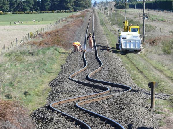
Differential movements can cause bridges to move from their supports and cause utilities and water pipes to break. During intense vibrations, pipes laid in the ground can “fold”, sticking into one another, or bend, coming to the surface, and railway rails become deformed. In earthquake-prone areas, structures must be designed and built in compliance with the building codes adopted for the given area in accordance with the seismic zoning map.
In densely populated areas, almost more damage than the earthquakes themselves are caused by fires that occur as a result of ruptures of gas pipelines and power lines, overturning of stoves, stoves and various heating devices. Fighting fires is complicated by the fact that the water supply is damaged and the streets are impassable due to the resulting rubble.
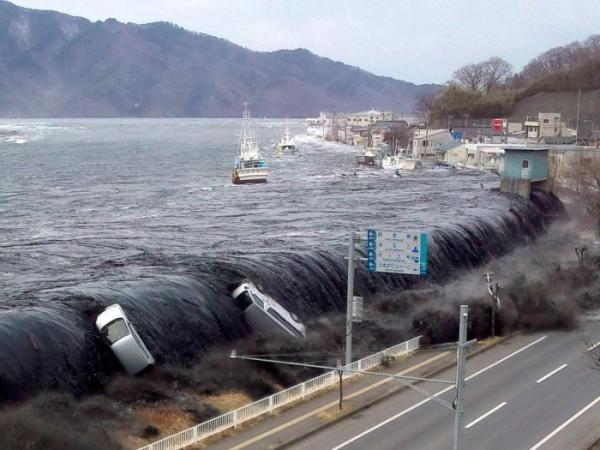
Related phenomena. Sometimes tremors are accompanied by a clearly audible low hum when the frequency of seismic vibrations lies in the range perceived by the human ear; sometimes such sounds are heard in the absence of tremors. They are quite common in some areas, although significant earthquakes are very rare. There are also numerous reports of the appearance of a glow during strong earthquakes. There is no generally accepted explanation for such phenomena yet. Tsunamis (large sea waves) occur when rapid vertical deformations of the seabed occur during underwater earthquakes. Tsunamis propagate in the deep oceans at speeds of 400–800 km/h and can cause destruction on coastlines thousands of kilometers from the epicenter. On the shores close to the epicenter, these waves sometimes reach a height of 30 m.
During many strong earthquakes, in addition to the main shocks, foreshocks (preceding earthquakes) and numerous aftershocks (earthquakes following the main shock) are recorded. Aftershocks are usually weaker than the mainshock and can recur over weeks or even years, becoming less and less frequent.
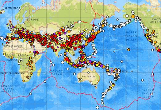
Geographical distribution of earthquakes. Most earthquakes are concentrated in two long, narrow zones. One of them frames the Pacific Ocean, and the second stretches from the Azores east to Southeast Asia.
The Pacific seismic zone runs along the west coast of South America. In Central America it splits into two branches, one following the island arc of the West Indies, and the other continuing north, expanding within the United States, to the western ranges of the Rocky Mountains. Further, this zone passes through the Aleutian Islands to Kamchatka and then through the Japanese Islands, the Philippines, New Guinea and the islands of the southwestern Pacific Ocean to New Zealand and Antarctica.
The second zone from the Azores extends east through the Alps and Turkey. In southern Asia, it expands and then narrows and changes direction to the meridional, passes through the territory of Myanmar, the islands of Sumatra and Java and connects with the circum-Pacific zone in the region of New Guinea.
There is also a smaller zone in the central part of the Atlantic Ocean, following along the Mid-Atlantic Ridge.
There are a number of areas where earthquakes occur quite frequently. These include East Africa, the Indian Ocean and in North America the valley of the St. River. Lawrence and northeastern USA.
Sometimes strong earthquakes occur in areas that are considered inactive, such as in Charleston, South Carolina in 1886.
Compared to shallow-focus earthquakes, deep-focus earthquakes have a more limited distribution. They have not been recorded within the Pacific zone from southern Mexico to the Aleutian Islands, and in the Mediterranean zone - west of the Carpathians. Deep-focus earthquakes are characteristic of the western edge of the Pacific Ocean, Southeast Asia and the western coast of South America. The zone with deep-focus sources is usually located along the zone of shallow-focus earthquakes on the continental side.
Earthquake forecast. To improve the accuracy of earthquake forecasts, it is necessary to better understand the mechanisms of stress accumulation in the earth's crust, creep and deformations on faults, to identify the relationships between heat flow from the Earth's interior and the spatial distribution of earthquakes, and also to establish patterns of earthquake recurrence depending on their magnitude.
In many areas of the globe where there is a possibility of strong earthquakes, geodynamic observations are carried out in order to detect earthquake precursors, among which changes in seismic activity, deformation of the earth's crust, anomalies in geomagnetic fields and heat flow, sharp changes in the properties of rocks (electrical, seismic, etc.), geochemical anomalies, water regime disturbances, atmospheric phenomena, as well as abnormal behavior of insects and other animals (biological precursors). This kind of research is carried out at special geodynamic testing sites (for example, Parkfield in California, Garm in Tajikistan, etc.). Since 1960, many seismic stations have been operating, equipped with highly sensitive recording equipment and powerful computers that allow them to quickly process data and determine the location of earthquake sources.
LITERATURE
Richter G.F. Elementary seismology. M., 1963
Rikitake T. Prediction of earthquakes. M., 1975
Seismic scale and methods for measuring seismic activity. M., 1975
Encyclopedia Around the World. 2008 .
The earth's firmament has always been a symbol of security. And today a person who is afraid of flying on an airplane feels protected only when he feels a flat surface under his feet. Therefore, the worst thing is when the ground literally disappears from under your feet. Earthquakes, even the weakest ones, undermine the sense of security so much that many of the consequences are associated not with destruction, but with panic and are of a psychological rather than physical nature. In addition, this is one of those disasters that humanity cannot prevent, and therefore many scientists are researching the causes of earthquakes, developing methods for recording tremors, forecasting and warning. The amount of knowledge already accumulated by humanity on this issue allows us to minimize losses in some cases. At the same time, examples of earthquakes in recent years clearly indicate that there is still much to be learned and done.
The essence of the phenomenon
At the heart of every earthquake is a seismic wave that leads to it. It arises as a result of powerful processes of varying depth. Quite minor earthquakes occur due to surface drift, often along faults. The causes of earthquakes that are deeper in location often have devastating consequences. They flow in zones along the edges of shifting plates that are plunging into the mantle. The processes occurring here lead to the most noticeable consequences.
Earthquakes happen every day, but most of them go unnoticed by people. They are only recorded with special devices. In this case, the greatest force of tremors and maximum destruction occur in the zone of the epicenter, the place above the source that generated the seismic waves.
Scales
Today there are several ways to determine the strength of a phenomenon. They are based on concepts such as the intensity of the earthquake, its energy class and magnitude. The last of these is a quantity that characterizes the amount of energy released in the form of seismic waves. This method of measuring the strength of a phenomenon was proposed in 1935 by Richter and is therefore popularly called the Richter scale. It is still used today, but, contrary to popular belief, each earthquake is assigned not points, but a certain magnitude value.
Earthquake scores, which are always given in the description of the consequences, are related to a different scale. It is based on a change in the amplitude of the wave, or the magnitude of the oscillations at the epicenter. The values on this scale also describe the intensity of earthquakes:
- 1-2 points: fairly weak tremors, recorded only by instruments;
- 3-4 points: noticeable in high-rise buildings, often noticeable by the swinging of a chandelier and the displacement of small objects, a person may feel dizzy;
- 5-7 points: tremors can be felt already on the ground, cracks may appear on the walls of buildings, plaster may fall off;
- 8 points: powerful tremors lead to deep cracks in the ground and noticeable damage to buildings;
- 9 points: walls of houses, often underground structures, are destroyed;
- 10-11 points: such an earthquake leads to collapses and landslides, collapse of buildings and bridges;
- 12 points: leads to the most catastrophic consequences, including severe changes in the landscape and even the direction of water movement in rivers.
Earthquake scores, which are given in various sources, are determined precisely on this scale.
Classification
The ability to predict any disaster comes from a clear understanding of what causes it. The main causes of earthquakes can be divided into two large groups: natural and artificial. The former are associated with changes in the subsoil, as well as with the influence of certain cosmic processes, the latter are caused by human activity. The classification of earthquakes is based on the cause that caused it. Among natural ones, tectonic, landslide, volcanic and others are distinguished. Let's look at them in more detail.
Tectonic earthquakes
The crust of our planet is constantly in motion. This is what underlies most earthquakes. The tectonic plates that make up the crust move relative to each other, collide, diverge and converge. In places of faults, where plate boundaries pass and a compression or tension force occurs, tectonic stress accumulates. As it grows, sooner or later it leads to the destruction and displacement of rocks, as a result of which seismic waves are born.
Vertical movements lead to the formation of failures or uplifting of rocks. Moreover, the displacement of the plates can be insignificant and amount to only a few centimeters, but the amount of energy released in this case is enough to cause serious destruction on the surface. Traces of such processes on earth are very noticeable. These could be, for example, displacements of one part of the field relative to another, deep cracks and failures.
Under the water column
The causes of earthquakes on the ocean floor are the same as on land - movements of lithospheric plates. Their consequences for people are somewhat different. Very often, the displacement of oceanic plates causes a tsunami. Having originated above the epicenter, the wave gradually gains height and often reaches ten meters, and sometimes fifty, near the shore.
According to statistics, over 80% of tsunamis hit the shores of the Pacific Ocean. Today, there are many services in seismic zones working to predict the occurrence and spread of destructive waves and notifying the population of the danger. However, people still have little protection from such natural disasters. Examples of earthquakes and tsunamis at the beginning of our century are further confirmation of this.
Volcanoes
When it comes to earthquakes, images of an eruption of hot magma that you once saw inevitably appear in your head. And this is not surprising: the two natural phenomena are interconnected. The cause of the earthquake may be volcanic activity. The contents of the fire mountains exert pressure on the surface of the earth. During the sometimes quite long period of preparation for an eruption, periodic and steam events occur that generate seismic waves. The pressure on the surface creates a so-called volcanic tremor (shaking). It consists of a series of small ground tremors.
Earthquakes are caused by processes occurring in the depths of both active and extinct volcanoes. In the latter case, they are a sign that the frozen mountain of fire may still wake up. Volcanic researchers often use microearthquakes to predict eruptions.
In many cases, it can be difficult to unambiguously classify an earthquake as tectonic or volcanic. Signs of the latter are the location of the epicenter in close proximity to the volcano and a relatively small magnitude.
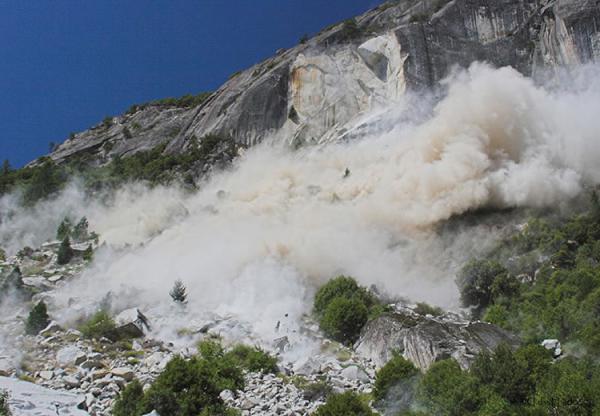
Collapses
An earthquake can also be caused by rock collapse. Landslides and landslides in the mountains arise as a result of various processes in the subsoil and natural phenomena, as well as human activity. Voids and caves in the ground can collapse and generate seismic waves. Rock falls are caused by insufficient drainage of water, which destroys seemingly solid structures. The collapse could also be caused by a tectonic earthquake. The collapse of an impressive mass causes minor seismic activity.
Such earthquakes are characterized by low strength. Typically, the volume of collapsed rock is not sufficient to cause significant fluctuations. However, sometimes earthquakes of this type lead to noticeable damage.
Classification by depth of occurrence
The main causes of earthquakes are associated, as already mentioned, with various processes in the bowels of the planet. One of the options for classifying such phenomena is based on the depth of their origin. Earthquakes are divided into three types:
- Surface - the source is located at a depth of no more than 100 km; approximately 51% of earthquakes belong to this type.
- Intermediate - depth varies in the range from 100 to 300 km; the sources of 36% of earthquakes are located in this segment.
- Deep-focus - below 300 km, this type accounts for about 13% of such disasters.
The most significant offshore earthquake of the third type occurred in Indonesia in 1996. Its source was located at a depth of over 600 km. This event allowed scientists to “enlighten” the planet’s interior to a considerable depth. In order to study the structure of the subsoil, almost all deep-focus earthquakes that are not dangerous to humans are used. Much of the data on the structure of the Earth was obtained from the study of the so-called Wadati-Benioff zone, which can be represented as a curved inclined line indicating the place where one tectonic plate sets under another.
Anthropogenic factor
The nature of earthquakes has changed somewhat since the beginning of the development of human technical knowledge. In addition to natural causes that cause tremors and seismic waves, artificial ones also appeared. Man, mastering nature and its resources, as well as increasing technical power, through his activities can provoke a natural disaster. The causes of earthquakes are underground explosions, the creation of large reservoirs, and the production of large volumes of oil and gas, which result in voids underground.
One of the rather serious problems in this regard is earthquakes that occur due to the creation and filling of reservoirs. Huge volumes and masses of water exert pressure on the subsoil and lead to changes in the hydrostatic equilibrium in the rocks. Moreover, the higher the dam created, the greater the likelihood of the occurrence of so-called induced seismic activity.
In places where earthquakes occur due to natural causes, human activity often overlaps with tectonic processes and provokes natural disasters. Such data imposes a certain responsibility on companies involved in the development of oil and gas fields.

Consequences
Strong earthquakes cause great destruction over large areas. The catastrophic nature of the consequences decreases with distance from the epicenter. The most dangerous results of destruction are various Collapse or deformation of production facilities associated with hazardous chemicals, leading to their release into the environment. The same can be said about burial grounds and nuclear waste disposal sites. Seismic activity can cause contamination of vast areas.
In addition to numerous destructions in cities, earthquakes have consequences of a different nature. Seismic waves, as already noted, can cause landslides, mudflows, floods and tsunamis. After a natural disaster, earthquake zones often change beyond recognition. Deep cracks and failures, soil washout - these and other “transformations” of the landscape lead to significant environmental changes. They can lead to the death of the flora and fauna of the area. This is facilitated by various gases and metal compounds coming from deep faults, and simply by the destruction of entire sections of the habitat.
Strong and weak
The most impressive destruction remains after megaearthquakes. They are characterized by a magnitude greater than 8.5. Such disasters are fortunately extremely rare. As a result of similar earthquakes in the distant past, some lakes and river beds were formed. A picturesque example of the “activity” of a natural disaster is Lake Gek-Gol in Azerbaijan.
Weak earthquakes are a hidden threat. As a rule, it is very difficult to find out about the likelihood of their occurrence on the ground, while phenomena of more impressive magnitude always leave identification marks. Therefore, all industrial and residential facilities near seismically active zones are under threat. Such buildings include, for example, many nuclear power plants and power plants in the United States, as well as disposal sites for radioactive and toxic waste.
Earthquake areas
The uneven distribution of seismically dangerous zones on the world map is also associated with the peculiarities of the causes of natural disasters. In the Pacific Ocean there is a seismic belt, with which, one way or another, an impressive part of earthquakes is associated. It includes Indonesia, the west coast of Central and South America, Japan, Iceland, Kamchatka, Hawaii, the Philippines, the Kuril Islands and Alaska. The second most active belt is the Eurasian one: the Pyrenees, the Caucasus, Tibet, the Apennines, the Himalayas, Altai, the Pamirs and the Balkans.
The earthquake map is full of other potential danger zones. All of them are associated with places of tectonic activity, where there is a high probability of collision of lithospheric plates, or with volcanoes.
The Russian earthquake map is also full of a sufficient number of potential and active sources. The most dangerous zones in this sense are Kamchatka, Eastern Siberia, the Caucasus, Altai, Sakhalin and the Kuril Islands. The most destructive earthquake in recent years in our country occurred on Sakhalin Island in 1995. Then the intensity of the natural disaster was almost eight points. The disaster led to the destruction of a large part of Neftegorsk.
The enormous danger of a natural disaster and the impossibility of preventing it forces scientists around the world to study earthquakes in detail: the causes and consequences, “identifying” signs and forecasting possibilities. It is interesting that technical progress, on the one hand, helps to more accurately predict threatening events, to detect the slightest changes in the internal processes of the Earth, and on the other hand, it also becomes a source of additional danger: accidents at hydroelectric and nuclear power plants, in mining sites, are added to surface faults. fires at work that are terrible in scale. The earthquake itself is a phenomenon as controversial as scientific and technological progress: it is destructive and dangerous, but it indicates that the planet is alive. According to scientists, a complete cessation of volcanic activity and earthquakes will mean the death of the planet in geological terms. The differentiation of the interior will be completed, the fuel that has been warming the interior of the Earth for several million years will run out. And it is still unclear whether there will be a place for people on the planet without earthquakes.
vibrations of the Earth caused by sudden changes in the condition of the planet's interior. These vibrations are elastic waves propagating at high speed through the rock mass. The most powerful earthquakes are sometimes felt at distances of more than 1,500 km from the source and can be recorded by seismographs (special highly sensitive instruments) even in the opposite hemisphere. The area where vibrations originate is called the earthquake source, and its projection onto the Earth's surface is called the earthquake epicenter. The sources of most earthquakes lie in the earth's crust at depths of no more than 16 km, but in some areas the depths of the sources reach 700 km. Thousands of earthquakes occur every day, but only a few of them are felt by humans.
Mentions of earthquakes are found in the Bible, in the treatises of ancient scientists Herodotus, Pliny and Livy, as well as in ancient Chinese and Japanese written sources. Until the 19th century Most reports of earthquakes contained descriptions heavily flavored with superstition and theories based on scanty and unreliable observations. A. Perry (France) began a series of systematic descriptions (catalogs) of earthquakes in 1840. In the 1850s, R. Malle (Ireland) compiled a large catalog of earthquakes, and his detailed report on the Naples earthquake in 1857 became one of the first strictly scientific descriptions of large earthquakes.
Richter G.F. Elementary seismology. M., 1963
Rikitake T. Prediction of earthquakes. M., 1975
Seismic scale and methods for measuring seismic activity. M., 1975
Find "EARTHQUAKES" on
Earthquakes are tremors and vibrations of the Earth's surface caused by natural causes (mainly tectonic processes) or artificial processes (explosions, filling of reservoirs, collapse of underground cavities in mine workings). Earthquakes are mainly caused by seismic processes. The cause of the earthquake is the displacement of rocks along a fault. The larger the “revived” fault, the greater the strength of the earthquake. The maximum faults are confined to the largest folded belts on Earth - the Pacific and Mediterranean. The longest belt of destructive earthquakes is located along the periphery of the Pacific Ocean. Earthquakes with a magnitude greater than 7.5 most often occur within its boundaries. The vast majority of the most powerful tsunamis are confined to this zone, since very often the epicenters are located on the ocean floor.
The second highly seismic zone - the Mediterranean belt - crosses the Eurasian continent in the sublatitudinal direction. It starts off the coast of the Atlantic Ocean (Portugal, Spain), covers the entire Mediterranean and Southern Europe, and continues through the highlands of Central Asia all the way to the Pacific Ocean.
The third largest seismic belt arose only 5-10 million years ago. This belt stretches along East Africa to the Red Sea and further to the Pamirs, Tien Shan, Lake Baikal and the Stanovoy Range. Most of it passes along ancient platforms (African, Siberian). Seismic activity is very high within this newly formed belt.
About a million earthquakes occur throughout the Earth each year, but most are so small that they go unnoticed. But about one earthquake per year is greater than magnitude 8.0; 10 - magnitude 7.0-7.9; 100 - magnitude 6.0-6.9; 1000 - magnitude 5.0-5.9. Such earthquakes can cause destruction on the Earth's surface and lead to loss of life, especially if the source of the earthquake is in a densely populated area. Destruction of buildings and structures is caused by vibrations of the earth's crust or giant tsunami waves that occur during seismic displacements on the ocean floor.
Seismic waves generated by earthquakes propagate in all directions from the source like sound waves. The point at which rock movement begins is called the focus, source or hypocenter, and the point on the earth's surface above the source is the epicenter of the earthquake. Shock waves propagate in all directions from the source; as they move away from it, their intensity decreases. To measure the strength of an earthquake, two scales are used: one to measure intensity and the other to measure magnitude